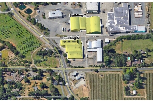
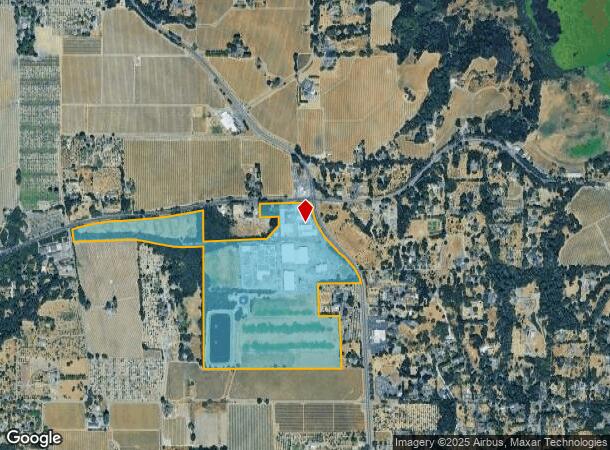
Property Record
2064 Hwy 116 Hwy N, Sebastopol, CA 95472
NEARBY LISTINGS FOR SALE OR LEASE
Property Detail
2064 Hwy 116 Hwy N
061-050-062
2007 FM 061-050-14,28-30,38,40,47,57 PER VM06-0011
Foodprocessing
Sonoma
X
California
06097C0715E
76.04 AC
2024
Sebastopol/Bodega
2025
North Bay/Santa Rosa
153405
Santa Rosa, CA
276,623 SF
DEMOGRAPHICS near 2064 Hwy 116 Hwy N
1 Mile
3 Mile
5 Mile
2024 Total Population
992
15,216
39,039
2029 Population
952
14,631
37,551
Pop Growth 2024-2029
(4.03%)
(3.84%)
(3.81%)
Average Age
47
48
46
2024 Total Households
383
6,375
15,073
HH Growth 2024-2029
(3.92%)
(3.84%)
(3.94%)
Median Household Inc
$114,903
$112,485
$111,488
Avg Household Size
2.50
2.30
2.50
2024 Avg HH Vehicles
2.00
2.00
2.00
Median Home Value
$885,620
$884,684
$832,372
Median Year Built
1967
1971
1974
Nearby Places
Map Layers
Map Styles
 Street
 Aerial
- Restaurants
- Banks
- Shops
- Fitness
- Groceries
PUBLIC TRANSPORTATION
AIRPORT
Charles M Schulz - Sonoma County
DRIVE
WALK
Distance
Charles M Schulz - Sonoma County
24 min
13.1 mi
Freight Ports
Port of Richmond
DRIVE
WALK
Distance
Port of Richmond
69 min
51.3 mi
Nearby Properties
Address
Land Use
TOTAL SIZE
Lot Size
Zoning
Address
Land Use
TOTAL SIZE
Lot Size
Zoning
90,449 SF
12.51 AC
DA20
Address
Land Use
TOTAL SIZE
Lot Size
Zoning
11,827 SF
19.16 AC
DA20
Address
Land Use
TOTAL SIZE
Lot Size
Zoning
89,970 SF
7.32 AC
Address
Land Use
TOTAL SIZE
Lot Size
Zoning
14,962 SF
20.02 AC
Address
Land Use
TOTAL SIZE
Lot Size
Zoning
26,734 SF
9.55 AC
Address
Land Use
TOTAL SIZE
Lot Size
Zoning
9.97 AC
Address
Land Use
TOTAL SIZE
Lot Size
Zoning
53,766 SF
20 AC
Address
Land Use
TOTAL SIZE
Lot Size
Zoning
1,040 SF
2.32 AC
CITYSE
Address
Land Use
TOTAL SIZE
Lot Size
Zoning
9,127 SF
262.94 AC
LEAB7FRZN
Address
Land Use
TOTAL SIZE
Lot Size
Zoning
41,874 SF
2.46 AC
Address
Land Use
TOTAL SIZE
Lot Size
Zoning
5,988 SF
20.11 AC
Address
Land Use
TOTAL SIZE
Lot Size
Zoning
46,649 SF
9.09 AC
AR5
Address
Land Use
TOTAL SIZE
Lot Size
Zoning
29,861 SF
4 AC
Address
Land Use
TOTAL SIZE
Lot Size
Zoning
48,349 SF
0.40 AC
C3
Address
Land Use
TOTAL SIZE
Lot Size
Zoning
18,403 SF
0.68 AC
Address
Land Use
TOTAL SIZE
Lot Size
Zoning
41,643 SF
1.77 AC
Address
Land Use
TOTAL SIZE
Lot Size
Zoning
18.05 AC
DA40
Address
Land Use
TOTAL SIZE
Lot Size
Zoning
23,572 SF
1.74 AC
CITYSE
Address
Land Use
TOTAL SIZE
Lot Size
Zoning
84,504 SF
8.55 AC
LCF2
Address
Land Use
TOTAL SIZE
Lot Size
Zoning
21,096 SF
1.74 AC
CD
Address
Land Use
TOTAL SIZE
Lot Size
Zoning
7,720 SF
56.30 AC
DA20
Address
Land Use
TOTAL SIZE
Lot Size
Zoning
33,150 SF
1 AC
MLPD
Address
Land Use
TOTAL SIZE
Lot Size
Zoning
43,968 SF
9.67 AC
Address
Land Use
TOTAL SIZE
Lot Size
Zoning
11,337 SF
55.57 AC
DA20
Address
Land Use
TOTAL SIZE
Lot Size
Zoning
4,100 SF
65.01 AC
LEA60
Address
Land Use
TOTAL SIZE
Lot Size
Zoning
47.64 AC
DA20
Address
Land Use
TOTAL SIZE
Lot Size
Zoning
46,285 SF
125.47 AC
Address
Land Use
TOTAL SIZE
Lot Size
Zoning
50,726 SF
32.32 AC
P2P
Address
Land Use
TOTAL SIZE
Lot Size
Zoning
47,724 SF
3.33 AC
CITYSE
The World's #1 Commercial Real Estate Marketplace
Connect with us
© 2025 CoStar Group
The information above has been obtained from sources believed reliable. While we do not doubt its accuracy we have not verified it and make no guarantee, warranty or representation about it. It is your responsibility to independently confirm its accuracy and completeness. Any projections, opinions, assumptions, or estimates used are for example only and do not represent the current or future performance of the property. The value of this transaction to you depends on tax and other factors which should be evaluated by your tax, financial, and legal advisors. You and your advisors should conduct a careful, independent investigation of the property to determine to your satisfaction the suitability of the property for your needs.