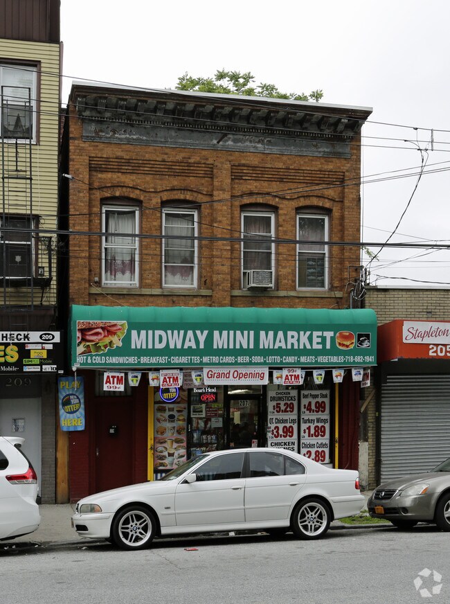
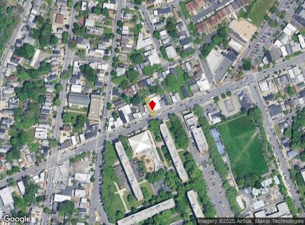
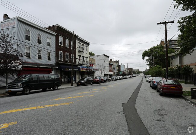
Property Record
207 Broad St, Staten Island, NY 10304
NEARBY LISTINGS FOR SALE OR LEASE
Property Detail
207 Broad St
New York-Jersey City-White Plains, NY-NJ
Property Of M Tompkins Stapleton
00541-0017
SECOND WARD
Commercialofficeresidentialmixeduse
Staten Island
X
New York
3604970327F
17
2024
0.06 AC
2025
Staten Island
002100
Long Island (New York)
2,600 SF
DEMOGRAPHICS near 207 Broad St
1 Mile
3 Mile
5 Mile
2024 Total Population
44,719
255,706
786,725
2029 Population
44,242
250,259
746,106
Pop Growth 2024-2029
(1.07%)
(2.13%)
(5.16%)
Average Age
38
41
40
2024 Total Households
15,043
94,393
267,264
HH Growth 2024-2029
(1.00%)
(2.42%)
(5.29%)
Median Household Inc
$56,500
$77,910
$70,461
Avg Household Size
2.80
2.60
2.80
2024 Avg HH Vehicles
1.00
1.00
1.00
Median Home Value
$521,979
$665,030
$678,125
Median Year Built
1961
1956
1952
Nearby Places
Map Layers
Map Styles
 Street
 Aerial
- Restaurants
- Banks
- Shops
- Fitness
- Groceries
PUBLIC TRANSPORTATION
TRANSIT/SUBWAY
Stapleton (Staten Island Railway - New York MTA Subway (The Subway))
DRIVE
WALK
Distance
Stapleton (Staten Island Railway - New York MTA Subway (The Subway))
3 min
10 min
0.5 mi
Clifton (Staten Island Railway - New York MTA Subway (The Subway))
DRIVE
WALK
Distance
Clifton (Staten Island Railway - New York MTA Subway (The Subway))
2 min
15 min
0.7 mi
COMMUTER RAIL
Stapleton (Staten Island Railway - New York MTA Subway (The Subway))
DRIVE
WALK
Distance
Stapleton (Staten Island Railway - New York MTA Subway (The Subway))
3 min
10 min
0.5 mi
Clifton (Staten Island Railway - New York MTA Subway (The Subway))
DRIVE
WALK
Distance
Clifton (Staten Island Railway - New York MTA Subway (The Subway))
2 min
15 min
0.7 mi
AIRPORT
Newark Liberty International
DRIVE
WALK
Distance
Newark Liberty International
28 min
16.4 mi
LaGuardia
DRIVE
WALK
Distance
LaGuardia
38 min
21.6 mi
John F Kennedy International
DRIVE
WALK
Distance
John F Kennedy International
41 min
24.1 mi
Freight Ports
New York Container Terminal
DRIVE
WALK
Distance
New York Container Terminal
14 min
7.2 mi
Nearby Properties
Address
Land Use
TOTAL SIZE
Lot Size
Zoning
Address
Land Use
TOTAL SIZE
Lot Size
Zoning
22.49 AC
HC
Address
Land Use
TOTAL SIZE
Lot Size
Zoning
686,130 SF
189.62 AC
R3-2
Address
Land Use
TOTAL SIZE
Lot Size
Zoning
640,077 SF
19.34 AC
R3-1
Address
Land Use
TOTAL SIZE
Lot Size
Zoning
30.92 AC
Address
Land Use
TOTAL SIZE
Lot Size
Zoning
17.60 AC
Address
Land Use
TOTAL SIZE
Lot Size
Zoning
115.33 AC
IH
Address
Land Use
TOTAL SIZE
Lot Size
Zoning
135,000 SF
117.71 AC
PARK
Address
Land Use
TOTAL SIZE
Lot Size
Zoning
236,591 SF
207.66 AC
R3-2
Address
Land Use
TOTAL SIZE
Lot Size
Zoning
73.86 AC
IH
Address
Land Use
TOTAL SIZE
Lot Size
Zoning
538,240 SF
12.08 AC
R2
Address
Land Use
TOTAL SIZE
Lot Size
Zoning
25.67 AC
Address
Land Use
TOTAL SIZE
Lot Size
Zoning
286,000 SF
12.63 AC
PARK
Address
Land Use
TOTAL SIZE
Lot Size
Zoning
521,405 SF
52.79 AC
R3-1
Address
Land Use
TOTAL SIZE
Lot Size
Zoning
111,000 SF
186.03 AC
PARK
Address
Land Use
TOTAL SIZE
Lot Size
Zoning
48.68 AC
IH
Address
Land Use
TOTAL SIZE
Lot Size
Zoning
Address
Land Use
TOTAL SIZE
Lot Size
Zoning
492,962 SF
8.12 AC
M1-1
Address
Land Use
TOTAL SIZE
Lot Size
Zoning
11 AC
WR
Address
Land Use
TOTAL SIZE
Lot Size
Zoning
19.26 AC
IH
Address
Land Use
TOTAL SIZE
Lot Size
Zoning
183,839 SF
9.74 AC
PARK
Address
Land Use
TOTAL SIZE
Lot Size
Zoning
23.72 AC
IH
Address
Land Use
TOTAL SIZE
Lot Size
Zoning
26,826 SF
9 AC
IH
Address
Land Use
TOTAL SIZE
Lot Size
Zoning
41.25 AC
IH
Address
Land Use
TOTAL SIZE
Lot Size
Zoning
183,215 SF
3.47 AC
C4-2
Address
Land Use
TOTAL SIZE
Lot Size
Zoning
119.28 AC
Address
Land Use
TOTAL SIZE
Lot Size
Zoning
240 SF
47.41 AC
R3-2
Address
Land Use
TOTAL SIZE
Lot Size
Zoning
476,145 SF
50.97 AC
R3-1
Address
Land Use
TOTAL SIZE
Lot Size
Zoning
43,068 SF
216.83 AC
PARK
Address
Land Use
TOTAL SIZE
Lot Size
Zoning
14.15 AC
Address
Land Use
TOTAL SIZE
Lot Size
Zoning
296,631 SF
6.70 AC
R4
The World's #1 Commercial Real Estate Marketplace
Connect with us
© 2025 CoStar Group
The information above has been obtained from sources believed reliable. While we do not doubt its accuracy we have not verified it and make no guarantee, warranty or representation about it. It is your responsibility to independently confirm its accuracy and completeness. Any projections, opinions, assumptions, or estimates used are for example only and do not represent the current or future performance of the property. The value of this transaction to you depends on tax and other factors which should be evaluated by your tax, financial, and legal advisors. You and your advisors should conduct a careful, independent investigation of the property to determine to your satisfaction the suitability of the property for your needs.