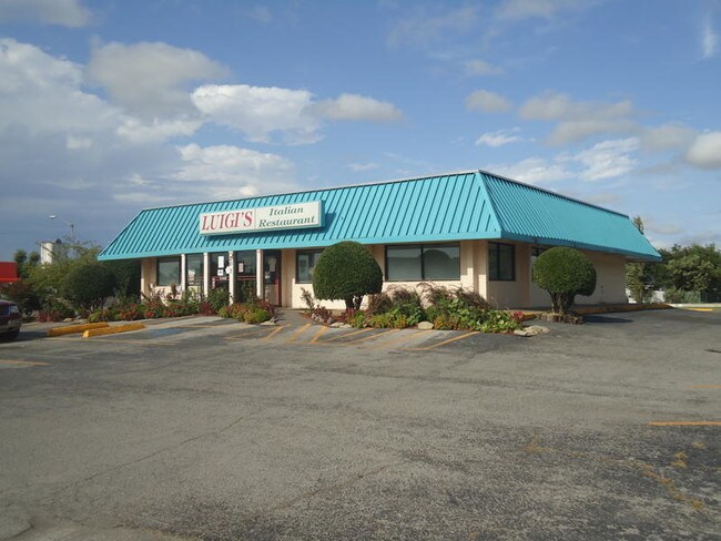
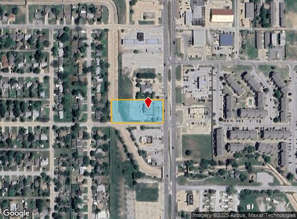
Property Record
207 Sw Sheridan Rd, Lawton, OK 73505
NEARBY LISTINGS FOR SALE OR LEASE
Property Detail
207 Sw Sheridan Rd
Lawton, OK
Highland Park
0024993
HIGHLAND PARK BLK 14 LOT 4 LESS 17' TO CITY LESS: BEG SE/C OF LOT 4 THN (N0*04'E) 10.0' THN (S45*04'W) 14.14' THN (S89*56'E)
Restaurantbuilding
Comanche
AE
Oklahoma
40031C0431E
4
2024
1.18 AC
2025
Oklahoma West Area
001400
Other Market Areas
3,038 SF
DEMOGRAPHICS near 207 Sw Sheridan Rd
1 Mile
3 Mile
5 Mile
2024 Total Population
10,531
58,136
89,415
2029 Population
11,004
60,538
92,553
Pop Growth 2024-2029
+ 4.49%
+ 4.13%
+ 3.51%
Average Age
38
36
36
2024 Total Households
4,658
23,408
33,674
HH Growth 2024-2029
+ 4.57%
+ 4.26%
+ 3.76%
Median Household Inc
$33,170
$39,224
$44,934
Avg Household Size
2.10
2.30
2.40
2024 Avg HH Vehicles
1.00
1.00
2.00
Median Home Value
$70,811
$100,306
$134,313
Median Year Built
1964
1967
1974
Nearby Places
Map Layers
Map Styles
 Street
 Aerial
- Restaurants
- Banks
- Shops
- Fitness
- Groceries
PUBLIC TRANSPORTATION
AIRPORT
Lawton-Fort Sill Regional
DRIVE
WALK
Distance
Lawton-Fort Sill Regional
8 min
3.0 mi
Freight Ports
Tulsa Port Of Catoosa
DRIVE
WALK
Distance
Tulsa Port Of Catoosa
226 min
211.0 mi
SALE & LEASE HISTORY
LISTING DATE
SALE/LEASE

Jan 22, 2018
For Sale
Aug 20, 2021
For Lease
Nearby Properties
Address
Land Use
TOTAL SIZE
Lot Size
Zoning
Address
Land Use
TOTAL SIZE
Lot Size
Zoning
74,800 SF
1.41 AC
Address
Land Use
TOTAL SIZE
Lot Size
Zoning
2,288 SF
2.94 AC
Address
Land Use
TOTAL SIZE
Lot Size
Zoning
30,000 SF
17.22 AC
Address
Land Use
TOTAL SIZE
Lot Size
Zoning
32,000 SF
5.32 AC
Address
Land Use
TOTAL SIZE
Lot Size
Zoning
22,987 SF
3.40 AC
Address
Land Use
TOTAL SIZE
Lot Size
Zoning
14,000 SF
17.19 AC
Address
Land Use
TOTAL SIZE
Lot Size
Zoning
13,326 SF
8.47 AC
Address
Land Use
TOTAL SIZE
Lot Size
Zoning
114,352 SF
14.84 AC
Address
Land Use
TOTAL SIZE
Lot Size
Zoning
800 SF
15.64 AC
Address
Land Use
TOTAL SIZE
Lot Size
Zoning
195,881 SF
15.39 AC
Address
Land Use
TOTAL SIZE
Lot Size
Zoning
12,068 SF
5.31 AC
Address
Land Use
TOTAL SIZE
Lot Size
Zoning
16,996 SF
12.16 AC
Address
Land Use
TOTAL SIZE
Lot Size
Zoning
2,376 SF
8.64 AC
Address
Land Use
TOTAL SIZE
Lot Size
Zoning
123,414 SF
17.50 AC
Address
Land Use
TOTAL SIZE
Lot Size
Zoning
117,301 SF
13.83 AC
Address
Land Use
TOTAL SIZE
Lot Size
Zoning
13,800 SF
13.79 AC
Address
Land Use
TOTAL SIZE
Lot Size
Zoning
36,063 SF
6.35 AC
Address
Land Use
TOTAL SIZE
Lot Size
Zoning
63,224 SF
2.66 AC
Address
Land Use
TOTAL SIZE
Lot Size
Zoning
82,509 SF
6.29 AC
Address
Land Use
TOTAL SIZE
Lot Size
Zoning
2,688 SF
4.50 AC
Address
Land Use
TOTAL SIZE
Lot Size
Zoning
41,192 SF
6.60 AC
Address
Land Use
TOTAL SIZE
Lot Size
Zoning
57,096 SF
16.03 AC
Address
Land Use
TOTAL SIZE
Lot Size
Zoning
6,251 SF
3.70 AC
Address
Land Use
TOTAL SIZE
Lot Size
Zoning
7,960 SF
0.58 AC
Address
Land Use
TOTAL SIZE
Lot Size
Zoning
3,292 SF
1.13 AC
Address
Land Use
TOTAL SIZE
Lot Size
Zoning
14,620 SF
1.13 AC
Address
Land Use
TOTAL SIZE
Lot Size
Zoning
52,568 SF
1.50 AC
Address
Land Use
TOTAL SIZE
Lot Size
Zoning
18,312 SF
3.08 AC
Address
Land Use
TOTAL SIZE
Lot Size
Zoning
61,984 SF
1.58 AC
Address
Land Use
TOTAL SIZE
Lot Size
Zoning
23,800 SF
4.34 AC
The World's #1 Commercial Real Estate Marketplace
Connect with us
© 2025 CoStar Group
The information above has been obtained from sources believed reliable. While we do not doubt its accuracy we have not verified it and make no guarantee, warranty or representation about it. It is your responsibility to independently confirm its accuracy and completeness. Any projections, opinions, assumptions, or estimates used are for example only and do not represent the current or future performance of the property. The value of this transaction to you depends on tax and other factors which should be evaluated by your tax, financial, and legal advisors. You and your advisors should conduct a careful, independent investigation of the property to determine to your satisfaction the suitability of the property for your needs.