Property Record
2073 Refugee Rd, Columbus, OH 43207

Save to a Folder
{{folder.Name}}
{{folder.ListingIds.length}} Properties
{{folder.ListingIds.length}} Property
Create a New Folder
Property Detail
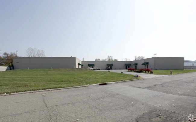
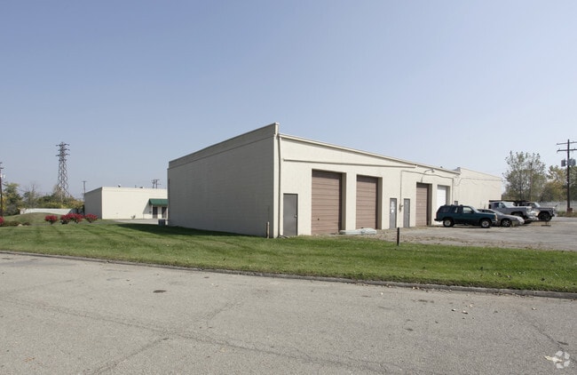
2073 Refugee Rd
Columbus, OH
REFUGEE PK 2.161AC SPARROW & DUNKIRK VOOS EST LOT 1-4
010-113471
Franklin
Industrialgeneral
Ohio
B and X Area of moderate flood hazard, usually the area between the limits of the 100-year and 500-year floods.
1-4
2024
2.40 AC
2025
Downtown South
008812
Columbus
22,400 SF
NEARBY LISTINGS FOR SALE OR LEASE
DEMOGRAPHICS near 2073 Refugee Rd
1 mile
3 mile
5 mile
2025 Total Population
6,105
101,431
242,884
2030 Population
6,429
106,003
253,117
Pop Growth 2025-2030
+ 5.31%
+ 4.51%
+ 4.21%
Average Age
41
38
38
2025 Total Households
2,477
42,395
105,087
HH Growth 2025-2030
+ 5.65%
+ 4.71%
+ 4.53%
Median Household Inc
$45,288
$58,316
$57,301
Avg Household Size
2.30
2.30
2.20
2025 Avg HH Vehicles
1.00
2.00
2.00
Median Home Value
$201,818
$235,000
$235,700
Median Year Built
1963
1959
1963
Nearby Places
Map Layers
Map Styles
 Street
 Aerial
Layers
 Traffic
 Biking
Places
Listings with unknown addresses are not visible on the map
- Restaurants
- Banks
- Shops
- Fitness
- Groceries
PUBLIC TRANSPORTATION
AIRPORT
Rickenbacker International
Drive
Walk
Distance
Rickenbacker International
16 min
8.5 mi
John Glenn Columbus International
Drive
Walk
Distance
John Glenn Columbus International
17 min
9.4 mi
Freight Ports
Port of Toledo
Drive
Walk
Distance
Port of Toledo
193 min
155.3 mi
SALE & LEASE HISTORY
LISTING DATE
SALE/LEASE

Sep 08, 2017
For Lease
Nearby Properties
Address
Land Use
TOTAL SIZE
Lot Size
Zoning
Address
Land Use
TOTAL SIZE
Lot Size
Zoning
1,467,891 SF
10.49 AC
Address
Land Use
TOTAL SIZE
Lot Size
Zoning
477,854 SF
0.72 AC
Address
Land Use
TOTAL SIZE
Lot Size
Zoning
339,231 SF
0.73 AC
Address
Land Use
TOTAL SIZE
Lot Size
Zoning
597,600 SF
68.91 AC
Address
Land Use
TOTAL SIZE
Lot Size
Zoning
573,031 SF
5.88 AC
Address
Land Use
TOTAL SIZE
Lot Size
Zoning
360,962 SF
33.91 AC
Address
Land Use
TOTAL SIZE
Lot Size
Zoning
157,856 SF
0.74 AC
Address
Land Use
TOTAL SIZE
Lot Size
Zoning
705,600 SF
43.41 AC
Address
Land Use
TOTAL SIZE
Lot Size
Zoning
192,038 SF
2.84 AC
Address
Land Use
TOTAL SIZE
Lot Size
Zoning
503,279 SF
1.99 AC
Address
Land Use
TOTAL SIZE
Lot Size
Zoning
143,397 SF
25.50 AC
Address
Land Use
TOTAL SIZE
Lot Size
Zoning
245,142 SF
11.56 AC
Address
Land Use
TOTAL SIZE
Lot Size
Zoning
462,840 SF
27.07 AC
Address
Land Use
TOTAL SIZE
Lot Size
Zoning
386,669 SF
32.15 AC
Address
Land Use
TOTAL SIZE
Lot Size
Zoning
209,884 SF
3.04 AC
Address
Land Use
TOTAL SIZE
Lot Size
Zoning
406,364 SF
22.03 AC
Address
Land Use
TOTAL SIZE
Lot Size
Zoning
125,219 SF
3.49 AC
Address
Land Use
TOTAL SIZE
Lot Size
Zoning
604,078 SF
50.18 AC
Address
Land Use
TOTAL SIZE
Lot Size
Zoning
79,472 SF
8.45 AC
Address
Land Use
TOTAL SIZE
Lot Size
Zoning
169,066 SF
11.72 AC
Address
Land Use
TOTAL SIZE
Lot Size
Zoning
761,098 SF
35.07 AC
Address
Land Use
TOTAL SIZE
Lot Size
Zoning
132,772 SF
0.62 AC
Address
Land Use
TOTAL SIZE
Lot Size
Zoning
113,547 SF
5.71 AC
Address
Land Use
TOTAL SIZE
Lot Size
Zoning
146,172 SF
26.42 AC
Address
Land Use
TOTAL SIZE
Lot Size
Zoning
600,255 SF
40.27 AC
Address
Land Use
TOTAL SIZE
Lot Size
Zoning
398,594 SF
25.50 AC
Address
Land Use
TOTAL SIZE
Lot Size
Zoning
204,782 SF
20.82 AC
Address
Land Use
TOTAL SIZE
Lot Size
Zoning
73,908 SF
9 AC
Address
Land Use
TOTAL SIZE
Lot Size
Zoning
253,674 SF
0.13 AC
Address
Land Use
TOTAL SIZE
Lot Size
Zoning
736,660 SF
34.40 AC
The World's #1 Commercial Real Estate Marketplace
Connect with us
© 2026 CoStar Group
The information above has been obtained from sources believed reliable. While we do not doubt its accuracy we have not verified it and make no guarantee, warranty or representation about it. It is your responsibility to independently confirm its accuracy and completeness. Any projections, opinions, assumptions, or estimates used are for example only and do not represent the current or future performance of the property. The value of this transaction to you depends on tax and other factors which should be evaluated by your tax, financial, and legal advisors. You and your advisors should conduct a careful, independent investigation of the property to determine to your satisfaction the suitability of the property for your needs.