Property Record
2080 Wilcox Rd, Stockton, CA 95215
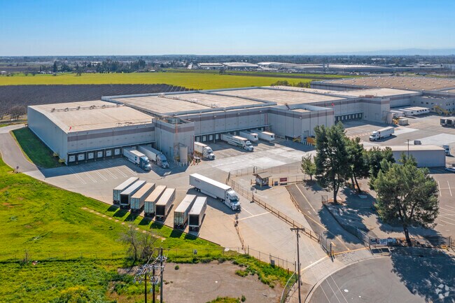

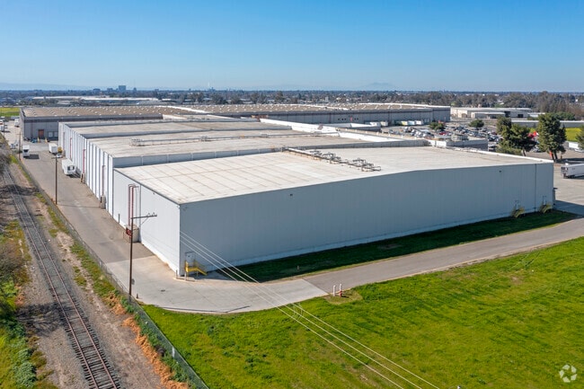

Property Detail
2080 Wilcox Rd
101-210-17
89-FM 02 & PT TO 16 & ST PM 16-21 88097342
Shipyard
SAN JOAQUIN
IL
California
AH Areas with a 1% annual chance of shallow flooding, usually in the form of a pond, withan average depth ranging from 1 to 3 feet. These areas have a 26% chance of flooding over the life of a 30-year mortgage.
16.53 AC
2025
NE Stockton
2025
Stockton/Modesto
003601
Stockton-Lodi, CA
219,572 SF
NEARBY LISTINGS FOR SALE OR LEASE
DEMOGRAPHICS near 2080 Wilcox Rd
1 mile
3 mile
5 mile
2025 Total Population
3,264
82,950
254,465
2030 Population
3,385
86,305
264,913
Pop Growth 2025-2030
+ 3.71%
+ 4.04%
+ 4.11%
Average Age
37
36
36
2025 Total Households
1,008
24,107
77,549
HH Growth 2025-2030
+ 3.57%
+ 4.18%
+ 4.32%
Median Household Inc
$66,170
$63,209
$65,759
Avg Household Size
3.20
3.30
3.10
2025 Avg HH Vehicles
2.00
2.00
2.00
Median Home Value
$379,937
$367,086
$386,161
Median Year Built
1968
1968
1972
Nearby Places
Map Layers
Map Styles
 Street
 Aerial
Layers
 Traffic
 Biking
Places
Listings with unknown addresses are not visible on the map
- Restaurants
- Banks
- Shops
- Fitness
- Groceries
PUBLIC TRANSPORTATION
COMMUTER RAIL
Stockton- Robert J Cabral Station (ACE Train - Altamont Corridor Express)
Drive
Walk
Distance
Stockton- Robert J Cabral Station (ACE Train - Altamont Corridor Express)
7 min
3.5 mi
Stockton (San Joaquins - Amtrak)
Drive
Walk
Distance
Stockton (San Joaquins - Amtrak)
9 min
4.6 mi
AIRPORT
Stockton Metro
Drive
Walk
Distance
Stockton Metro
15 min
9.4 mi
Freight Ports
Port of Stockton
Drive
Walk
Distance
Port of Stockton
13 min
7.9 mi
Nearby Properties
Address
Land Use
TOTAL SIZE
Lot Size
Zoning
Address
Land Use
TOTAL SIZE
Lot Size
Zoning
530,700 SF
8.35 AC
Address
Land Use
TOTAL SIZE
Lot Size
Zoning
152,000 SF
1.31 AC
Address
Land Use
TOTAL SIZE
Lot Size
Zoning
9,750 SF
136.94 AC
AU20
Address
Land Use
TOTAL SIZE
Lot Size
Zoning
502,000 SF
19.76 AC
Address
Land Use
TOTAL SIZE
Lot Size
Zoning
652,548 SF
35.24 AC
IL
Address
Land Use
TOTAL SIZE
Lot Size
Zoning
121,574 SF
5.49 AC
RHD
Address
Land Use
TOTAL SIZE
Lot Size
Zoning
192,389 SF
47.61 AC
Address
Land Use
TOTAL SIZE
Lot Size
Zoning
1,312 SF
7.44 AC
Address
Land Use
TOTAL SIZE
Lot Size
Zoning
62,588 SF
43.56 AC
IW
Address
Land Use
TOTAL SIZE
Lot Size
Zoning
37,846 SF
2.94 AC
Address
Land Use
TOTAL SIZE
Lot Size
Zoning
2.42 AC
Address
Land Use
TOTAL SIZE
Lot Size
Zoning
2,876 SF
10.54 AC
Address
Land Use
TOTAL SIZE
Lot Size
Zoning
5,264 SF
9.82 AC
IL
Address
Land Use
TOTAL SIZE
Lot Size
Zoning
102,190 SF
10.34 AC
Address
Land Use
TOTAL SIZE
Lot Size
Zoning
95,838 SF
10.10 AC
Address
Land Use
TOTAL SIZE
Lot Size
Zoning
126,108 SF
12.43 AC
Address
Land Use
TOTAL SIZE
Lot Size
Zoning
129,750 SF
8.63 AC
Address
Land Use
TOTAL SIZE
Lot Size
Zoning
261,860 SF
7.48 AC
IW
Address
Land Use
TOTAL SIZE
Lot Size
Zoning
8 AC
IL
Address
Land Use
TOTAL SIZE
Lot Size
Zoning
76,500 SF
7.03 AC
Address
Land Use
TOTAL SIZE
Lot Size
Zoning
65,516 SF
10.56 AC
RM
Address
Land Use
TOTAL SIZE
Lot Size
Zoning
83,337 SF
7.17 AC
RM
Address
Land Use
TOTAL SIZE
Lot Size
Zoning
5,684 SF
17 AC
Address
Land Use
TOTAL SIZE
Lot Size
Zoning
8,265 SF
2.87 AC
IL
Address
Land Use
TOTAL SIZE
Lot Size
Zoning
10,556 SF
1.15 AC
Address
Land Use
TOTAL SIZE
Lot Size
Zoning
199,500 SF
8.74 AC
IW
Address
Land Use
TOTAL SIZE
Lot Size
Zoning
202,752 SF
9.40 AC
IL
Address
Land Use
TOTAL SIZE
Lot Size
Zoning
3.55 AC
Address
Land Use
TOTAL SIZE
Lot Size
Zoning
46,336 SF
11.08 AC
The World's #1 Commercial Real Estate Marketplace
Connect with us
© 2026 CoStar Group
The information above has been obtained from sources believed reliable. While we do not doubt its accuracy we have not verified it and make no guarantee, warranty or representation about it. It is your responsibility to independently confirm its accuracy and completeness. Any projections, opinions, assumptions, or estimates used are for example only and do not represent the current or future performance of the property. The value of this transaction to you depends on tax and other factors which should be evaluated by your tax, financial, and legal advisors. You and your advisors should conduct a careful, independent investigation of the property to determine to your satisfaction the suitability of the property for your needs.