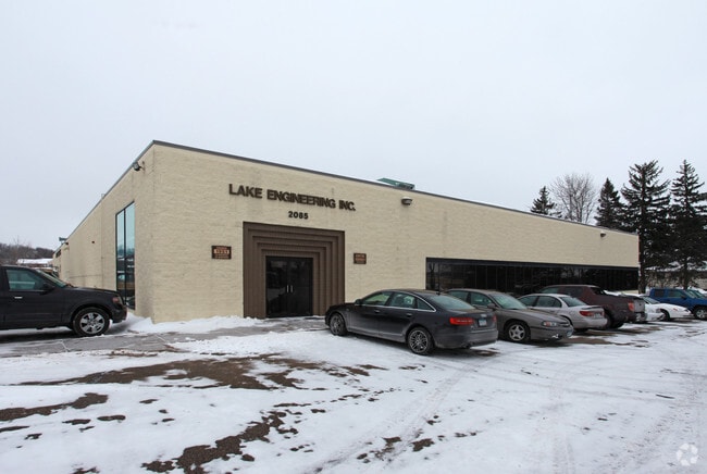
Property Record
2085 Daniels St, Long Lake, MN 55356

NEARBY LISTINGS FOR SALE OR LEASE
Property Detail
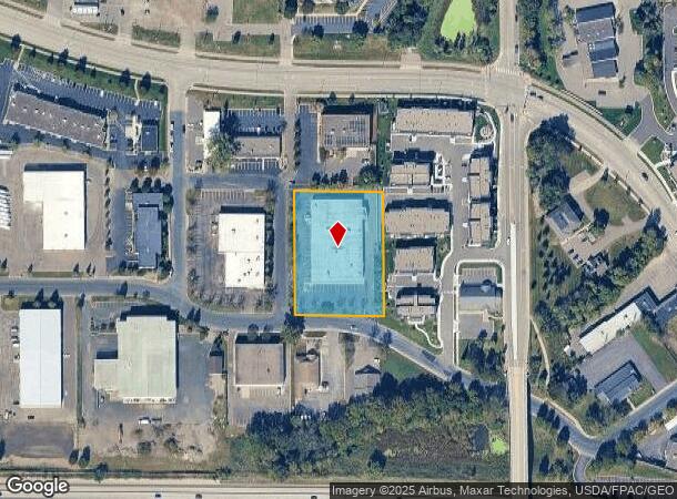
2085 Daniels St
Minneapolis-St. Paul-Bloomington, MN-WI
Shaughnessy Circle
34-118-23-24-0052
LOT 003 BLOCK 001 A SHAUGHNESSY CIRCLE N 310 FT OF LOT 3 SUBJ TO RD 222 X 310
Industrialgeneral
Hennepin
X
Minnesota
27019C0105D
3
2024
1.58 AC
2024
Southwest
027202
Minneapolis/St Paul
DEMOGRAPHICS near 2085 Daniels St
1 Mile
3 Mile
5 Mile
2024 Total Population
3,153
9,999
55,048
2029 Population
3,124
9,927
54,419
Pop Growth 2024-2029
(0.92%)
(0.72%)
(1.14%)
Average Age
42
43
43
2024 Total Households
1,217
3,863
21,814
HH Growth 2024-2029
(1.15%)
(0.83%)
(1.27%)
Median Household Inc
$141,867
$157,443
$130,356
Avg Household Size
2.60
2.60
2.50
2024 Avg HH Vehicles
2.00
2.00
2.00
Median Home Value
$617,977
$718,976
$562,785
Median Year Built
1979
1980
1980
Nearby Places
Map Layers
Map Styles
 Street
 Aerial
- Restaurants
- Banks
- Shops
- Fitness
- Groceries
PUBLIC TRANSPORTATION
AIRPORT
Minneapolis-St Paul International/Wold-Chamberlain
DRIVE
WALK
Distance
Minneapolis-St Paul International/Wold-Chamberlain
37 min
25.6 mi
Nearby Properties
Address
Land Use
TOTAL SIZE
Lot Size
Zoning
Address
Land Use
TOTAL SIZE
Lot Size
Zoning
0.99 AC
Address
Land Use
TOTAL SIZE
Lot Size
Zoning
0.44 AC
Address
Land Use
TOTAL SIZE
Lot Size
Zoning
3.50 AC
Address
Land Use
TOTAL SIZE
Lot Size
Zoning
2.37 AC
Address
Land Use
TOTAL SIZE
Lot Size
Zoning
2.27 AC
Address
Land Use
TOTAL SIZE
Lot Size
Zoning
23.01 AC
Address
Land Use
TOTAL SIZE
Lot Size
Zoning
Address
Land Use
TOTAL SIZE
Lot Size
Zoning
2.94 AC
Address
Land Use
TOTAL SIZE
Lot Size
Zoning
2.73 AC
Address
Land Use
TOTAL SIZE
Lot Size
Zoning
Address
Land Use
TOTAL SIZE
Lot Size
Zoning
1.32 AC
Address
Land Use
TOTAL SIZE
Lot Size
Zoning
20.78 AC
Address
Land Use
TOTAL SIZE
Lot Size
Zoning
1.89 AC
Address
Land Use
TOTAL SIZE
Lot Size
Zoning
10.43 AC
Address
Land Use
TOTAL SIZE
Lot Size
Zoning
9,286 SF
0.72 AC
Address
Land Use
TOTAL SIZE
Lot Size
Zoning
7,304 SF
1.26 AC
Address
Land Use
TOTAL SIZE
Lot Size
Zoning
Address
Land Use
TOTAL SIZE
Lot Size
Zoning
Address
Land Use
TOTAL SIZE
Lot Size
Zoning
Address
Land Use
TOTAL SIZE
Lot Size
Zoning
Address
Land Use
TOTAL SIZE
Lot Size
Zoning
Address
Land Use
TOTAL SIZE
Lot Size
Zoning
Address
Land Use
TOTAL SIZE
Lot Size
Zoning
Address
Land Use
TOTAL SIZE
Lot Size
Zoning
2.75 AC
Address
Land Use
TOTAL SIZE
Lot Size
Zoning
Address
Land Use
TOTAL SIZE
Lot Size
Zoning
Address
Land Use
TOTAL SIZE
Lot Size
Zoning
2.07 AC
Address
Land Use
TOTAL SIZE
Lot Size
Zoning
Address
Land Use
TOTAL SIZE
Lot Size
Zoning
0.79 AC
Address
Land Use
TOTAL SIZE
Lot Size
Zoning
The World's #1 Commercial Real Estate Marketplace
Connect with us
© 2026 CoStar Group
The information above has been obtained from sources believed reliable. While we do not doubt its accuracy we have not verified it and make no guarantee, warranty or representation about it. It is your responsibility to independently confirm its accuracy and completeness. Any projections, opinions, assumptions, or estimates used are for example only and do not represent the current or future performance of the property. The value of this transaction to you depends on tax and other factors which should be evaluated by your tax, financial, and legal advisors. You and your advisors should conduct a careful, independent investigation of the property to determine to your satisfaction the suitability of the property for your needs.