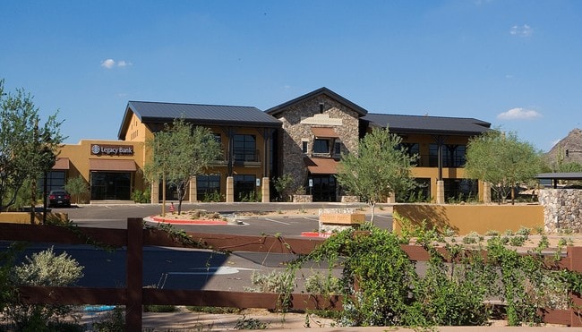
Property Record
20909 N 90Th Pl, Scottsdale, AZ 85255

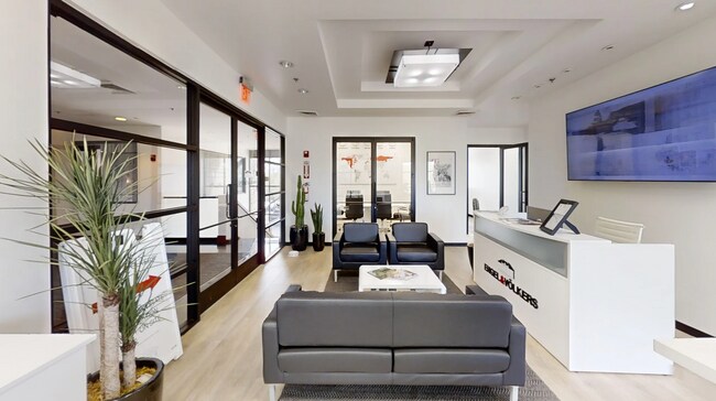
Current Lease Availabilities
Property Detail
20909 N 90Th Pl
217-62-280Z
TH PT N2 SW4 SEC 19 T4N R5E DAF COM INT THOMPSON PEAK PKWY AS SHOWN IN MCR 430-04 AND NWLY COR OF 90TH ST & 90TH PL AS SHOWN IN MCR 499-32 SD PT ALSO POB TH ALG WLY R/W LN OF 90TH ST S 29D 25M W 203.96F TO BEG CUR TH SWLY ALG CUR HAV A RAD OF 25F CON
Officebuilding
Maricopa
PAD
Arizona
AO River or stream flood hazard areas, and areas with a 1% or greater chance of shallow flooding each year. These areas have a 26% chance of flooding over the life of a 30-year mortgage.
2.5
2025
1.84 AC
2025
Scottsdale Airpark
216855
Phoenix
13,970 SF
Phoenix-Mesa-Chandler, AZ
NEARBY LISTINGS FOR SALE OR LEASE
DEMOGRAPHICS near 20909 N 90Th Pl
1 mile
3 mile
5 mile
2025 Total Population
5,158
39,425
114,073
2030 Population
5,539
42,050
121,609
Pop Growth 2025-2030
+ 7.39%
+ 6.66%
+ 6.61%
Average Age
49
47
46
2025 Total Households
2,197
17,417
52,697
HH Growth 2025-2030
+ 7.69%
+ 6.92%
+ 6.97%
Median Household Inc
$194,651
$137,698
$121,968
Avg Household Size
2.30
2.20
2.10
2025 Avg HH Vehicles
2.00
2.00
2.00
Median Home Value
$1,058,567
$1,017,374
$890,810
Median Year Built
2004
2001
1998
Nearby Places
Map Layers
Map Styles
 Street
 Aerial
Layers
 Traffic
 Biking
Places
Listings with unknown addresses are not visible on the map
- Restaurants
- Banks
- Shops
- Fitness
- Groceries
PUBLIC TRANSPORTATION
AIRPORT
Phoenix Sky Harbor International
Drive
Walk
Distance
Phoenix Sky Harbor International
35 min
24.2 mi
Phoenix-Mesa Gateway
Drive
Walk
Distance
Phoenix-Mesa Gateway
55 min
39.6 mi
Nearby Properties
Address
Land Use
TOTAL SIZE
Lot Size
Zoning
Address
Land Use
TOTAL SIZE
Lot Size
Zoning
20.98 AC
Address
Land Use
TOTAL SIZE
Lot Size
Zoning
1,479,005 SF
12.55 AC
PC
Address
Land Use
TOTAL SIZE
Lot Size
Zoning
Address
Land Use
TOTAL SIZE
Lot Size
Zoning
Address
Land Use
TOTAL SIZE
Lot Size
Zoning
694,644 SF
34.41 AC
C-C
Address
Land Use
TOTAL SIZE
Lot Size
Zoning
229,856 SF
7.71 AC
C-T
Address
Land Use
TOTAL SIZE
Lot Size
Zoning
794,304 SF
14.59 AC
WTP
Address
Land Use
TOTAL SIZE
Lot Size
Zoning
762,044 SF
16.66 AC
I1
Address
Land Use
TOTAL SIZE
Lot Size
Zoning
368,657 SF
40.11 AC
Address
Land Use
TOTAL SIZE
Lot Size
Zoning
734,840 SF
33.12 AC
M-H
Address
Land Use
TOTAL SIZE
Lot Size
Zoning
884,258 SF
30.63 AC
PCD
Address
Land Use
TOTAL SIZE
Lot Size
Zoning
90.73 AC
O-S
Address
Land Use
TOTAL SIZE
Lot Size
Zoning
580,604 SF
7.52 AC
C-T
Address
Land Use
TOTAL SIZE
Lot Size
Zoning
255,313 SF
22.54 AC
PNC
Address
Land Use
TOTAL SIZE
Lot Size
Zoning
385,376 SF
13.65 AC
PAD
Address
Land Use
TOTAL SIZE
Lot Size
Zoning
702,652 SF
4.58 AC
Address
Land Use
TOTAL SIZE
Lot Size
Zoning
41.63 AC
I-1
Address
Land Use
TOTAL SIZE
Lot Size
Zoning
498,417 SF
5.12 AC
PRC
Address
Land Use
TOTAL SIZE
Lot Size
Zoning
731,843 SF
29.85 AC
M-H
Address
Land Use
TOTAL SIZE
Lot Size
Zoning
328,616 SF
10.56 AC
PAD
Address
Land Use
TOTAL SIZE
Lot Size
Zoning
397,568 SF
16.71 AC
PAD
Address
Land Use
TOTAL SIZE
Lot Size
Zoning
163,122 SF
8.63 AC
C-C
Address
Land Use
TOTAL SIZE
Lot Size
Zoning
191,639 SF
31.94 AC
O-S
Address
Land Use
TOTAL SIZE
Lot Size
Zoning
397,700 SF
7.68 AC
C-C
Address
Land Use
TOTAL SIZE
Lot Size
Zoning
69.27 AC
I-P
Address
Land Use
TOTAL SIZE
Lot Size
Zoning
161,955 SF
2.65 AC
Address
Land Use
TOTAL SIZE
Lot Size
Zoning
157,340 SF
4.40 AC
PC
The World's #1 Commercial Real Estate Marketplace
Connect with us
© 2026 CoStar Group
The information above has been obtained from sources believed reliable. While we do not doubt its accuracy we have not verified it and make no guarantee, warranty or representation about it. It is your responsibility to independently confirm its accuracy and completeness. Any projections, opinions, assumptions, or estimates used are for example only and do not represent the current or future performance of the property. The value of this transaction to you depends on tax and other factors which should be evaluated by your tax, financial, and legal advisors. You and your advisors should conduct a careful, independent investigation of the property to determine to your satisfaction the suitability of the property for your needs.