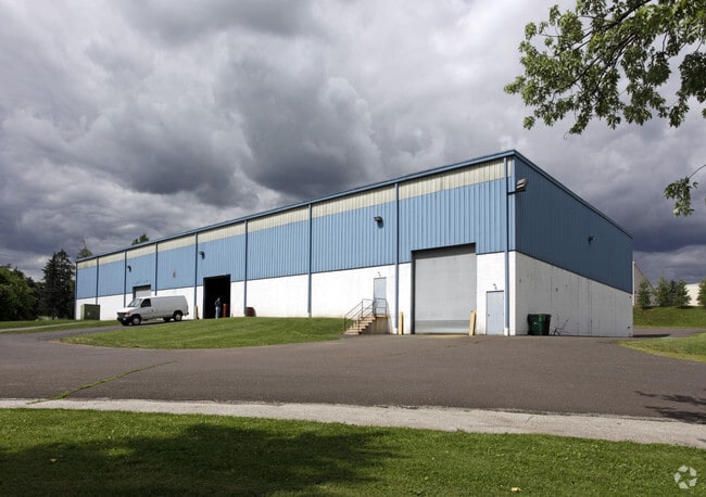
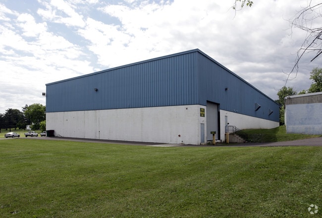
Property Record
2092 W Main St, West Norriton, PA 19403

Current Lease Availabilities
NEARBY LISTINGS FOR SALE OR LEASE
Property Detail
2092 W Main St
63-00-07123-005
INCLUDES UNIT 54
Warehouse
Montgomery
A
Pennsylvania
42091C0245G
1
2024
7.50 AC
2025
East Montgomery Cty
203402
Philadelphia
36,400 SF
Philadelphia-Camden-Wilmington, PA-NJ-DE-MD
DEMOGRAPHICS near 2092 W Main St
1 Mile
3 Mile
5 Mile
2024 Total Population
8,890
91,819
165,653
2029 Population
9,021
93,235
169,105
Pop Growth 2024-2029
+ 1.47%
+ 1.54%
+ 2.08%
Average Age
45
40
41
2024 Total Households
4,001
35,430
65,426
HH Growth 2024-2029
+ 1.45%
+ 1.51%
+ 2.20%
Median Household Inc
$83,984
$85,066
$94,130
Avg Household Size
2.20
2.40
2.40
2024 Avg HH Vehicles
2.00
2.00
2.00
Median Home Value
$270,322
$311,616
$347,862
Median Year Built
1972
1969
1971
Nearby Places
Map Layers
Map Styles
 Street
 Aerial
- Restaurants
- Banks
- Shops
- Fitness
- Groceries
PUBLIC TRANSPORTATION
COMMUTER RAIL
Main Street (Norristown) (R6 - Southeastern Pennsylvania Transportation Authority Regional Rail (SEPTA Regional Rail))
DRIVE
WALK
Distance
Main Street (Norristown) (R6 - Southeastern Pennsylvania Transportation Authority Regional Rail (SEPTA Regional Rail))
6 min
2.3 mi
Elm Street (Norristown) (R6 - Southeastern Pennsylvania Transportation Authority Regional Rail (SEPTA Regional Rail))
DRIVE
WALK
Distance
Elm Street (Norristown) (R6 - Southeastern Pennsylvania Transportation Authority Regional Rail (SEPTA Regional Rail))
7 min
2.7 mi
AIRPORT
Philadelphia International
DRIVE
WALK
Distance
Philadelphia International
50 min
29.4 mi
Freight Ports
Port of Philadelphia
DRIVE
WALK
Distance
Port of Philadelphia
45 min
26.7 mi
Nearby Properties
Address
Land Use
TOTAL SIZE
Lot Size
Zoning
Address
Land Use
TOTAL SIZE
Lot Size
Zoning
1,807,465 SF
120.12 AC
R2
Address
Land Use
TOTAL SIZE
Lot Size
Zoning
365,348 SF
80.44 AC
IN
Address
Land Use
TOTAL SIZE
Lot Size
Zoning
679,715 SF
58.23 AC
R2
Address
Land Use
TOTAL SIZE
Lot Size
Zoning
124,789 SF
155.99 AC
INO
Address
Land Use
TOTAL SIZE
Lot Size
Zoning
972,935 SF
20.51 AC
INO
Address
Land Use
TOTAL SIZE
Lot Size
Zoning
388,042 SF
24.45 AC
SM
Address
Land Use
TOTAL SIZE
Lot Size
Zoning
617,174 SF
25.32 AC
HR
Address
Land Use
TOTAL SIZE
Lot Size
Zoning
454,933 SF
17.85 AC
SM
Address
Land Use
TOTAL SIZE
Lot Size
Zoning
422,975 SF
92.05 AC
RA
Address
Land Use
TOTAL SIZE
Lot Size
Zoning
413,892 SF
21.94 AC
SM
Address
Land Use
TOTAL SIZE
Lot Size
Zoning
502,080 SF
11.36 AC
RA
Address
Land Use
TOTAL SIZE
Lot Size
Zoning
348,190 SF
68 AC
R1
Address
Land Use
TOTAL SIZE
Lot Size
Zoning
503,942 SF
11.26 AC
RA
Address
Land Use
TOTAL SIZE
Lot Size
Zoning
199,873 SF
71.47 AC
INO
Address
Land Use
TOTAL SIZE
Lot Size
Zoning
381,927 SF
5.10 AC
SM
Address
Land Use
TOTAL SIZE
Lot Size
Zoning
396,137 SF
2.26 AC
HR
Address
Land Use
TOTAL SIZE
Lot Size
Zoning
367,115 SF
62.90 AC
AGR
Address
Land Use
TOTAL SIZE
Lot Size
Zoning
273,724 SF
8.05 AC
INO
Address
Land Use
TOTAL SIZE
Lot Size
Zoning
94,055 SF
16.24 AC
LI
Address
Land Use
TOTAL SIZE
Lot Size
Zoning
320,737 SF
0.98 AC
TC
Address
Land Use
TOTAL SIZE
Lot Size
Zoning
639,052 SF
45 AC
SM
Address
Land Use
TOTAL SIZE
Lot Size
Zoning
416,392 SF
26.56 AC
HR
Address
Land Use
TOTAL SIZE
Lot Size
Zoning
208,680 SF
4.54 AC
LCI
Address
Land Use
TOTAL SIZE
Lot Size
Zoning
299,018 SF
9.42 AC
SC
Address
Land Use
TOTAL SIZE
Lot Size
Zoning
311,784 SF
21.82 AC
A
Address
Land Use
TOTAL SIZE
Lot Size
Zoning
211,739 SF
14.14 AC
CR
Address
Land Use
TOTAL SIZE
Lot Size
Zoning
162,230 SF
6.16 AC
SM
Address
Land Use
TOTAL SIZE
Lot Size
Zoning
305,760 SF
22.50 AC
R2
Address
Land Use
TOTAL SIZE
Lot Size
Zoning
189,885 SF
12.91 AC
C1
Address
Land Use
TOTAL SIZE
Lot Size
Zoning
252,272 SF
18.86 AC
A
The World's #1 Commercial Real Estate Marketplace
Connect with us
© 2026 CoStar Group
The information above has been obtained from sources believed reliable. While we do not doubt its accuracy we have not verified it and make no guarantee, warranty or representation about it. It is your responsibility to independently confirm its accuracy and completeness. Any projections, opinions, assumptions, or estimates used are for example only and do not represent the current or future performance of the property. The value of this transaction to you depends on tax and other factors which should be evaluated by your tax, financial, and legal advisors. You and your advisors should conduct a careful, independent investigation of the property to determine to your satisfaction the suitability of the property for your needs.