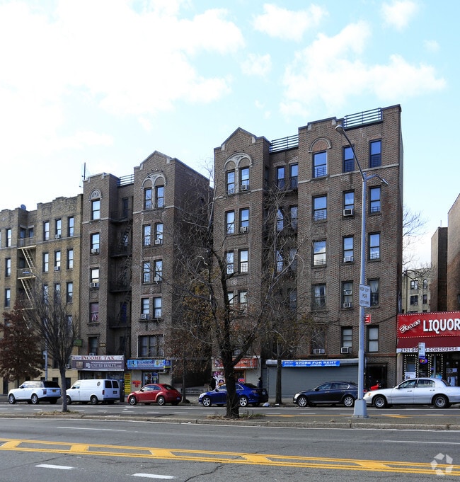
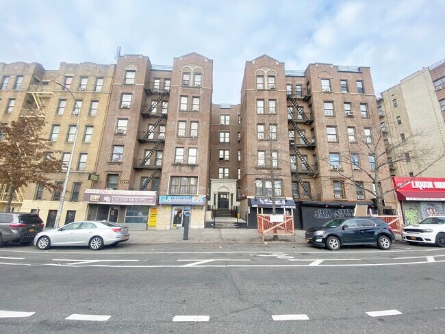
Property Record
2095 Grand Concourse, Bronx, NY 10453


Current Lease Availabilities
NEARBY LISTINGS FOR SALE OR LEASE
Property Detail
2095 Grand Concourse
03161-0026
Estate/Frances T Lord
Apartment
Bronx
X
New York
3604970082F
26
2024
0.24 AC
2025
Fordham Heights
023501
Westchester/So Connecticut
36,633 SF
New York-Jersey City-White Plains, NY-NJ
DEMOGRAPHICS near 2095 Grand Concourse
1 mile
3 mile
5 mile
2024 Total Population
230,842
1,255,102
2,015,782
2029 Population
217,150
1,168,600
1,874,663
Pop Growth 2024-2029
(5.93%)
(6.89%)
(7.00%)
Average Age
36
38
39
2024 Total Households
76,193
449,814
746,320
HH Growth 2024-2029
(6.63%)
(7.51%)
(7.45%)
Median Household Inc
$38,765
$42,836
$47,242
Avg Household Size
2.80
2.60
2.50
2024 Avg HH Vehicles
.00
.00
1.00
Median Home Value
$329,712
$476,654
$545,574
Median Year Built
1948
1949
1952
Nearby Places
Map Layers
Map Styles
 Street
 Aerial
Transit
 Traffic
 Biking
Places
Listings with unknown addresses are not visible on the map
- Restaurants
- Banks
- Shops
- Fitness
- Groceries
PUBLIC TRANSPORTATION
TRANSIT/SUBWAY
182-183 Streets (B - New York MTA Subway (The Subway), D - New York MTA Subway (The Subway))
Drive
Walk
Distance
182-183 Streets (B - New York MTA Subway (The Subway), D - New York MTA Subway (The Subway))
2 min
4 min
0.2 mi
Tremont Avenue (B - New York MTA Subway (The Subway), D - New York MTA Subway (The Subway))
Drive
Walk
Distance
Tremont Avenue (B - New York MTA Subway (The Subway), D - New York MTA Subway (The Subway))
1 min
6 min
0.3 mi
Burnside Avenue (4 - New York MTA Subway (The Subway))
Drive
Walk
Distance
Burnside Avenue (4 - New York MTA Subway (The Subway))
1 min
7 min
0.4 mi
183 Street (4 - New York MTA Subway (The Subway))
Drive
Walk
Distance
183 Street (4 - New York MTA Subway (The Subway))
2 min
9 min
0.5 mi
Tremont Station (Harlem Line - Metro-North Commuter Railroad Company (Metro-North))
Drive
Walk
Distance
Tremont Station (Harlem Line - Metro-North Commuter Railroad Company (Metro-North))
2 min
12 min
0.6 mi
COMMUTER RAIL
Tremont Station (Harlem Line - Metro-North Commuter Railroad Company (Metro-North))
Drive
Walk
Distance
Tremont Station (Harlem Line - Metro-North Commuter Railroad Company (Metro-North))
4 min
13 min
0.6 mi
Fordham Station (Harlem Line - Metro-North Commuter Railroad Company (Metro-North), New Haven Line - Metro-North Commuter Railroad Company (Metro-North))
Drive
Walk
Distance
Fordham Station (Harlem Line - Metro-North Commuter Railroad Company (Metro-North), New Haven Line - Metro-North Commuter Railroad Company (Metro-North))
4 min
19 min
1.0 mi
AIRPORT
LaGuardia
Drive
Walk
Distance
LaGuardia
21 min
10.0 mi
John F Kennedy International
Drive
Walk
Distance
John F Kennedy International
30 min
19.6 mi
Westchester County
Drive
Walk
Distance
Westchester County
38 min
24.0 mi
Freight Ports
NY - Red Hook Container Terminal
Drive
Walk
Distance
NY - Red Hook Container Terminal
33 min
18.2 mi
Nearby Properties
Address
Land Use
TOTAL SIZE
Lot Size
Zoning
Address
Land Use
TOTAL SIZE
Lot Size
Zoning
3,693,539 SF
8.37 AC
R8
Address
Land Use
TOTAL SIZE
Lot Size
Zoning
1,299,700 SF
29.82 AC
R6
Address
Land Use
TOTAL SIZE
Lot Size
Zoning
1,743,584 SF
77.87 AC
R6
Address
Land Use
TOTAL SIZE
Lot Size
Zoning
24.08 AC
B2-A
Address
Land Use
TOTAL SIZE
Lot Size
Zoning
1,427,393 SF
39.94 AC
R4
Address
Land Use
TOTAL SIZE
Lot Size
Zoning
1,651,267 SF
1.23 AC
R8
Address
Land Use
TOTAL SIZE
Lot Size
Zoning
481,172 SF
205.58 AC
PARK
Address
Land Use
TOTAL SIZE
Lot Size
Zoning
895,256 SF
8.32 AC
R7-1
Address
Land Use
TOTAL SIZE
Lot Size
Zoning
0.36 AC
R8
Address
Land Use
TOTAL SIZE
Lot Size
Zoning
891,040 SF
5.63 AC
R8
Address
Land Use
TOTAL SIZE
Lot Size
Zoning
1,311,800 SF
9.89 AC
C4-4
Address
Land Use
TOTAL SIZE
Lot Size
Zoning
23.12 AC
PARK
Address
Land Use
TOTAL SIZE
Lot Size
Zoning
1,237,424 SF
21.25 AC
R6
Address
Land Use
TOTAL SIZE
Lot Size
Zoning
204,200 SF
1.68 AC
R7-1
Address
Land Use
TOTAL SIZE
Lot Size
Zoning
42.68 AC
P1
Address
Land Use
TOTAL SIZE
Lot Size
Zoning
807,327 SF
0.60 AC
R8
Address
Land Use
TOTAL SIZE
Lot Size
Zoning
39 AC
P1
Address
Land Use
TOTAL SIZE
Lot Size
Zoning
2,531,670 SF
17.15 AC
R7-2
Address
Land Use
TOTAL SIZE
Lot Size
Zoning
390,750 SF
265 AC
PARK
Address
Land Use
TOTAL SIZE
Lot Size
Zoning
890,134 SF
8.79 AC
R7-2
Address
Land Use
TOTAL SIZE
Lot Size
Zoning
317,485 SF
1.57 AC
R8
Address
Land Use
TOTAL SIZE
Lot Size
Zoning
380,920 SF
0.72 AC
R10A
Address
Land Use
TOTAL SIZE
Lot Size
Zoning
43.65 AC
PARK
Address
Land Use
TOTAL SIZE
Lot Size
Zoning
890,134 SF
8.79 AC
R7-2
Address
Land Use
TOTAL SIZE
Lot Size
Zoning
890,134 SF
8.79 AC
R7-2
Address
Land Use
TOTAL SIZE
Lot Size
Zoning
890,134 SF
8.79 AC
R7-2
Address
Land Use
TOTAL SIZE
Lot Size
Zoning
890,134 SF
0.54 AC
R7-2
Address
Land Use
TOTAL SIZE
Lot Size
Zoning
890,134 SF
8.79 AC
R7-2
Address
Land Use
TOTAL SIZE
Lot Size
Zoning
890,134 SF
0.54 AC
R7-2
Address
Land Use
TOTAL SIZE
Lot Size
Zoning
890,134 SF
8.79 AC
R7-2
The World's #1 Commercial Real Estate Marketplace
Connect with us
© 2026 CoStar Group
The information above has been obtained from sources believed reliable. While we do not doubt its accuracy we have not verified it and make no guarantee, warranty or representation about it. It is your responsibility to independently confirm its accuracy and completeness. Any projections, opinions, assumptions, or estimates used are for example only and do not represent the current or future performance of the property. The value of this transaction to you depends on tax and other factors which should be evaluated by your tax, financial, and legal advisors. You and your advisors should conduct a careful, independent investigation of the property to determine to your satisfaction the suitability of the property for your needs.