Property Record
210 E Fm 78, Schertz, TX 78154
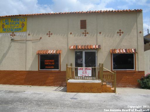
Property Detail
210 E Fm 78
San Antonio-New Braunfels, TX
ABS: 221 SUR: G MALPAZ 0.2350 AC.
2G0210-0000-05100-0-00
GUADALUPE
Residentialacreage
Texas
B and X Area of moderate flood hazard, usually the area between the limits of the 100-year and 500-year floods.
0.98 AC
2024
Guadalupe County
2025
San Antonio
210705
NEARBY LISTINGS FOR SALE OR LEASE
DEMOGRAPHICS near 210 E Fm 78
1 mile
3 mile
5 mile
2025 Total Population
7,297
66,329
162,843
2030 Population
8,048
72,103
175,734
Pop Growth 2025-2030
+ 10.29%
+ 8.71%
+ 7.92%
Average Age
41
39
38
2025 Total Households
2,951
24,437
57,843
HH Growth 2025-2030
+ 10.91%
+ 9.14%
+ 8.13%
Median Household Inc
$69,800
$99,207
$95,340
Avg Household Size
2.50
2.70
2.80
2025 Avg HH Vehicles
2.00
2.00
2.00
Median Home Value
$198,735
$314,310
$297,325
Median Year Built
1976
1999
2002
Nearby Places
Map Layers
Map Styles
 Street
 Aerial
Transit
 Traffic
 Biking
Places
Listings with unknown addresses are not visible on the map
- Restaurants
- Banks
- Shops
- Fitness
- Groceries
PUBLIC TRANSPORTATION
AIRPORT
San Antonio International
Drive
Walk
Distance
San Antonio International
23 min
14.8 mi
Freight Ports
Calhoun Port
Drive
Walk
Distance
Calhoun Port
175 min
145.3 mi
SALE & LEASE HISTORY
LISTING DATE
SALE/LEASE

Sep 25, 2016
For Lease
Sep 23, 2016
For Sale
Nearby Properties
Address
Land Use
TOTAL SIZE
Lot Size
Zoning
Address
Land Use
TOTAL SIZE
Lot Size
Zoning
116.47 AC
Address
Land Use
TOTAL SIZE
Lot Size
Zoning
251,707 SF
20.22 AC
Address
Land Use
TOTAL SIZE
Lot Size
Zoning
412,136 SF
49 AC
Address
Land Use
TOTAL SIZE
Lot Size
Zoning
271,018 SF
13.75 AC
Address
Land Use
TOTAL SIZE
Lot Size
Zoning
90,699 SF
16.47 AC
Address
Land Use
TOTAL SIZE
Lot Size
Zoning
263,617 SF
8.62 AC
Address
Land Use
TOTAL SIZE
Lot Size
Zoning
147,780 SF
15 AC
Address
Land Use
TOTAL SIZE
Lot Size
Zoning
398,442 SF
14.62 AC
Address
Land Use
TOTAL SIZE
Lot Size
Zoning
113,091 SF
12.60 AC
Address
Land Use
TOTAL SIZE
Lot Size
Zoning
190,717 SF
9.99 AC
Address
Land Use
TOTAL SIZE
Lot Size
Zoning
342,612 SF
28.49 AC
Address
Land Use
TOTAL SIZE
Lot Size
Zoning
186,055 SF
17.44 AC
Address
Land Use
TOTAL SIZE
Lot Size
Zoning
102,924 SF
14.23 AC
Address
Land Use
TOTAL SIZE
Lot Size
Zoning
85,117 SF
11 AC
Address
Land Use
TOTAL SIZE
Lot Size
Zoning
102,700 SF
4.68 AC
Address
Land Use
TOTAL SIZE
Lot Size
Zoning
124,690 SF
24.47 AC
Address
Land Use
TOTAL SIZE
Lot Size
Zoning
77,652 SF
15.08 AC
Address
Land Use
TOTAL SIZE
Lot Size
Zoning
187,102 SF
18.40 AC
Address
Land Use
TOTAL SIZE
Lot Size
Zoning
77,010 SF
10 AC
Address
Land Use
TOTAL SIZE
Lot Size
Zoning
99,263 SF
13.69 AC
Address
Land Use
TOTAL SIZE
Lot Size
Zoning
134,157 SF
5.95 AC
Address
Land Use
TOTAL SIZE
Lot Size
Zoning
74,606 SF
8.14 AC
Address
Land Use
TOTAL SIZE
Lot Size
Zoning
77,668 SF
3.53 AC
Address
Land Use
TOTAL SIZE
Lot Size
Zoning
22,841 SF
11 AC
Address
Land Use
TOTAL SIZE
Lot Size
Zoning
50,635 SF
8.17 AC
Address
Land Use
TOTAL SIZE
Lot Size
Zoning
113,910 SF
5.72 AC
Address
Land Use
TOTAL SIZE
Lot Size
Zoning
57,000 SF
4 AC
Address
Land Use
TOTAL SIZE
Lot Size
Zoning
124,618 SF
8.59 AC
Address
Land Use
TOTAL SIZE
Lot Size
Zoning
69,638 SF
7.32 AC
Address
Land Use
TOTAL SIZE
Lot Size
Zoning
76,897 SF
15.57 AC
The World's #1 Commercial Real Estate Marketplace
Connect with us
© 2026 CoStar Group
The information above has been obtained from sources believed reliable. While we do not doubt its accuracy we have not verified it and make no guarantee, warranty or representation about it. It is your responsibility to independently confirm its accuracy and completeness. Any projections, opinions, assumptions, or estimates used are for example only and do not represent the current or future performance of the property. The value of this transaction to you depends on tax and other factors which should be evaluated by your tax, financial, and legal advisors. You and your advisors should conduct a careful, independent investigation of the property to determine to your satisfaction the suitability of the property for your needs.