Property Record
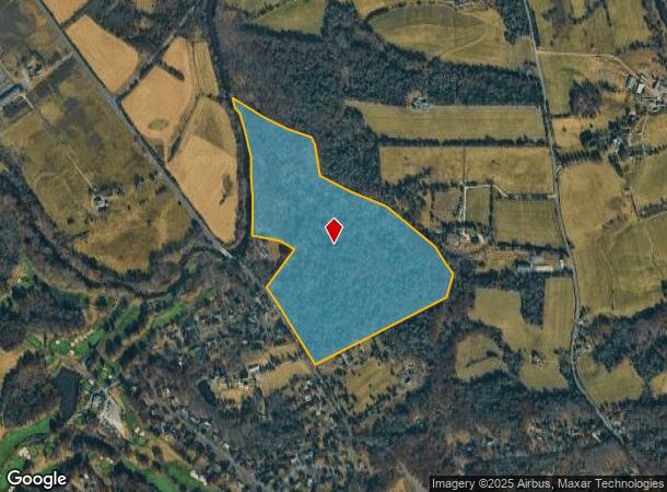
210 Lamington Rd, Branchburg, NJ 08876

NEARBY LISTINGS FOR SALE OR LEASE
Property Detail
210 Lamington Rd
Newark, NJ-PA
FACILITY NAME: VACANT LAND
05-00003-0000-00016
Somerset
Governmentalpublicusegeneral
New Jersey
X
16
34019C0277F
74.76 AC
2023
Route 22 West
2025
Northern New Jersey
053604
DEMOGRAPHICS near 210 Lamington Rd
1 Mile
3 Mile
5 Mile
2024 Total Population
718
16,251
69,008
2029 Population
734
16,314
69,222
Pop Growth 2024-2029
+ 2.23%
+ 0.39%
+ 0.31%
Average Age
44
43
43
2024 Total Households
281
5,824
26,440
HH Growth 2024-2029
+ 2.14%
+ 0.36%
+ 0.27%
Median Household Inc
$162,500
$157,176
$140,879
Avg Household Size
2.50
2.70
2.60
2024 Avg HH Vehicles
2.00
2.00
2.00
Median Home Value
$692,748
$589,243
$499,418
Median Year Built
1968
1984
1985
Nearby Places
Map Layers
Map Styles
 Street
 Aerial
- Restaurants
- Banks
- Shops
- Fitness
- Groceries
PUBLIC TRANSPORTATION
COMMUTER RAIL
North Branch (Raritan Valley Line - NJ Transit Commuter Rail (NJ Transit))
DRIVE
WALK
Distance
North Branch (Raritan Valley Line - NJ Transit Commuter Rail (NJ Transit))
7 min
2.9 mi
White House (Raritan Valley Line - NJ Transit Commuter Rail (NJ Transit))
DRIVE
WALK
Distance
White House (Raritan Valley Line - NJ Transit Commuter Rail (NJ Transit))
11 min
5.7 mi
AIRPORT
Newark Liberty International
DRIVE
WALK
Distance
Newark Liberty International
42 min
34.7 mi
Trenton Mercer
DRIVE
WALK
Distance
Trenton Mercer
58 min
34.8 mi
Freight Ports
New York Container Terminal
DRIVE
WALK
Distance
New York Container Terminal
50 min
38.1 mi
Nearby Properties
Address
Land Use
TOTAL SIZE
Lot Size
Zoning
Address
Land Use
TOTAL SIZE
Lot Size
Zoning
236.88 AC
CF
Address
Land Use
TOTAL SIZE
Lot Size
Zoning
4,397 SF
26.86 AC
I-1
Address
Land Use
TOTAL SIZE
Lot Size
Zoning
18.46 AC
I
Address
Land Use
TOTAL SIZE
Lot Size
Zoning
243.82 AC
R10
Address
Land Use
TOTAL SIZE
Lot Size
Zoning
20 AC
I-1
Address
Land Use
TOTAL SIZE
Lot Size
Zoning
38.79 AC
I-1
Address
Land Use
TOTAL SIZE
Lot Size
Zoning
23.64 AC
I,IP
Address
Land Use
TOTAL SIZE
Lot Size
Zoning
13.48 AC
I2
Address
Land Use
TOTAL SIZE
Lot Size
Zoning
118.92 AC
R10
Address
Land Use
TOTAL SIZE
Lot Size
Zoning
20.18 AC
I-1
Address
Land Use
TOTAL SIZE
Lot Size
Zoning
25.08 AC
I-1
Address
Land Use
TOTAL SIZE
Lot Size
Zoning
10.34 AC
RS-1
Address
Land Use
TOTAL SIZE
Lot Size
Zoning
12.05 AC
I-IP
Address
Land Use
TOTAL SIZE
Lot Size
Zoning
23.11 AC
I-1
Address
Land Use
TOTAL SIZE
Lot Size
Zoning
18.81 AC
O
Address
Land Use
TOTAL SIZE
Lot Size
Zoning
25.75 AC
I-1
Address
Land Use
TOTAL SIZE
Lot Size
Zoning
5.98 AC
I-IP
Address
Land Use
TOTAL SIZE
Lot Size
Zoning
22.84 AC
I-1
Address
Land Use
TOTAL SIZE
Lot Size
Zoning
13.99 AC
I-2
Address
Land Use
TOTAL SIZE
Lot Size
Zoning
12.18 AC
I-IP
Address
Land Use
TOTAL SIZE
Lot Size
Zoning
18,288 SF
3.78 AC
I-IP
Address
Land Use
TOTAL SIZE
Lot Size
Zoning
12.83 AC
I-1
Address
Land Use
TOTAL SIZE
Lot Size
Zoning
7.81 AC
I-Z
Address
Land Use
TOTAL SIZE
Lot Size
Zoning
22.33 AC
R40
Address
Land Use
TOTAL SIZE
Lot Size
Zoning
8.30 AC
I
Address
Land Use
TOTAL SIZE
Lot Size
Zoning
6.32 AC
I-IP
Address
Land Use
TOTAL SIZE
Lot Size
Zoning
6.56 AC
I-1
Address
Land Use
TOTAL SIZE
Lot Size
Zoning
8.40 AC
I&IP
Address
Land Use
TOTAL SIZE
Lot Size
Zoning
34.44 AC
Address
Land Use
TOTAL SIZE
Lot Size
Zoning
20,048 SF
3 AC
AR
The World's #1 Commercial Real Estate Marketplace
Connect with us
© 2025 CoStar Group
The information above has been obtained from sources believed reliable. While we do not doubt its accuracy we have not verified it and make no guarantee, warranty or representation about it. It is your responsibility to independently confirm its accuracy and completeness. Any projections, opinions, assumptions, or estimates used are for example only and do not represent the current or future performance of the property. The value of this transaction to you depends on tax and other factors which should be evaluated by your tax, financial, and legal advisors. You and your advisors should conduct a careful, independent investigation of the property to determine to your satisfaction the suitability of the property for your needs.