Property Record
2100 47Th Ter E, Bradenton, FL 34203
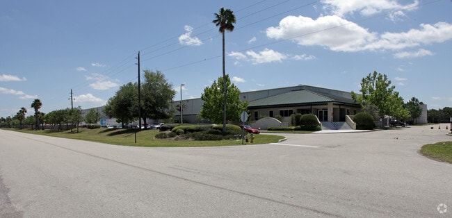

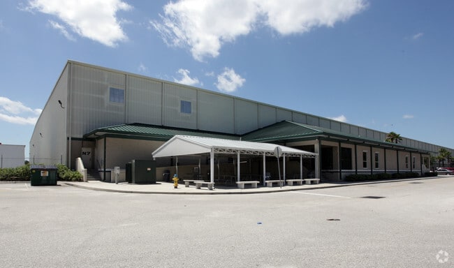
Property Detail
2100 47Th Ter E
16375-0205-9
LOT 1 BEALLS SUBDIVISION PI#16375.0205/9
Warehouse
Manatee
LM LIGHT M
Florida
B and X Area of moderate flood hazard, usually the area between the limits of the 100-year and 500-year floods.
1
2024
48.54 AC
2025
Manatee
000811
Tampa/St Petersburg
901,196 SF
North Port-Bradenton-Sarasota, FL
NEARBY LISTINGS FOR SALE OR LEASE
DEMOGRAPHICS near 2100 47Th Ter E
1 mile
3 mile
5 mile
2025 Total Population
7,756
96,625
213,145
2030 Population
8,591
107,526
237,784
Pop Growth 2025-2030
+ 10.77%
+ 11.28%
+ 11.56%
Average Age
41
43
45
2025 Total Households
2,756
38,308
91,630
HH Growth 2025-2030
+ 10.96%
+ 11.63%
+ 11.94%
Median Household Inc
$64,535
$52,027
$62,868
Avg Household Size
2.60
2.40
2.20
2025 Avg HH Vehicles
2.00
2.00
2.00
Median Home Value
$318,571
$232,140
$316,157
Median Year Built
1992
1982
1985
Nearby Places
Map Layers
Map Styles
 Street
 Aerial
Transit
 Traffic
 Biking
Places
Listings with unknown addresses are not visible on the map
- Restaurants
- Banks
- Shops
- Fitness
- Groceries
PUBLIC TRANSPORTATION
AIRPORT
Sarasota/Bradenton International
Drive
Walk
Distance
Sarasota/Bradenton International
17 min
7.7 mi
Freight Ports
Port Manatee
Drive
Walk
Distance
Port Manatee
27 min
15.1 mi
Nearby Properties
Address
Land Use
TOTAL SIZE
Lot Size
Zoning
Address
Land Use
TOTAL SIZE
Lot Size
Zoning
349,711 SF
49.51 AC
BR_SD1
Address
Land Use
TOTAL SIZE
Lot Size
Zoning
318,507 SF
10.47 AC
BR_T4R,BR_
Address
Land Use
TOTAL SIZE
Lot Size
Zoning
2,401,721 SF
142.14 AC
PD-UI
Address
Land Use
TOTAL SIZE
Lot Size
Zoning
294,609 SF
19.15 AC
RMF9
Address
Land Use
TOTAL SIZE
Lot Size
Zoning
375,171 SF
20 AC
PD-MU
Address
Land Use
TOTAL SIZE
Lot Size
Zoning
397,863 SF
21.60 AC
GC GENERA
Address
Land Use
TOTAL SIZE
Lot Size
Zoning
198,036 SF
8.32 AC
GC GENERA
Address
Land Use
TOTAL SIZE
Lot Size
Zoning
115,400 SF
22.55 AC
LM LIGHT M
Address
Land Use
TOTAL SIZE
Lot Size
Zoning
185,617 SF
13.68 AC
BR_R-2
Address
Land Use
TOTAL SIZE
Lot Size
Zoning
187,000 SF
8.93 AC
Address
Land Use
TOTAL SIZE
Lot Size
Zoning
214,350 SF
16.07 AC
LM LIGHT M
Address
Land Use
TOTAL SIZE
Lot Size
Zoning
296,983 SF
34.84 AC
PD-MU
Address
Land Use
TOTAL SIZE
Lot Size
Zoning
485,150 SF
56.44 AC
HC,GC
Address
Land Use
TOTAL SIZE
Lot Size
Zoning
163,394 SF
15.49 AC
PD-MU
Address
Land Use
TOTAL SIZE
Lot Size
Zoning
145,200 SF
8.66 AC
Address
Land Use
TOTAL SIZE
Lot Size
Zoning
148,992 SF
9.81 AC
RMF-9,GC
Address
Land Use
TOTAL SIZE
Lot Size
Zoning
126,505 SF
20 AC
RSF-2
Address
Land Use
TOTAL SIZE
Lot Size
Zoning
193,682 SF
10.67 AC
PD-C
Address
Land Use
TOTAL SIZE
Lot Size
Zoning
419,956 SF
18.46 AC
LM LIGHT M
Address
Land Use
TOTAL SIZE
Lot Size
Zoning
145,200 SF
8.99 AC
Address
Land Use
TOTAL SIZE
Lot Size
Zoning
157,713 SF
12.84 AC
GC GENERA
Address
Land Use
TOTAL SIZE
Lot Size
Zoning
124,129 SF
23.29 AC
PDC
Address
Land Use
TOTAL SIZE
Lot Size
Zoning
143,582 SF
14.42 AC
LM LIGHT M
Address
Land Use
TOTAL SIZE
Lot Size
Zoning
231,364 SF
27.50 AC
PD-PI
Address
Land Use
TOTAL SIZE
Lot Size
Zoning
220,685 SF
27.21 AC
PD-C
Address
Land Use
TOTAL SIZE
Lot Size
Zoning
322,364 SF
32.93 AC
HM HEAVY M
Address
Land Use
TOTAL SIZE
Lot Size
Zoning
234,818 SF
18.20 AC
BR_R-2
Address
Land Use
TOTAL SIZE
Lot Size
Zoning
193,582 SF
20.58 AC
PD-C,NC-S
Address
Land Use
TOTAL SIZE
Lot Size
Zoning
141,244 SF
18.08 AC
LM,HM
The World's #1 Commercial Real Estate Marketplace
Connect with us
© 2026 CoStar Group
The information above has been obtained from sources believed reliable. While we do not doubt its accuracy we have not verified it and make no guarantee, warranty or representation about it. It is your responsibility to independently confirm its accuracy and completeness. Any projections, opinions, assumptions, or estimates used are for example only and do not represent the current or future performance of the property. The value of this transaction to you depends on tax and other factors which should be evaluated by your tax, financial, and legal advisors. You and your advisors should conduct a careful, independent investigation of the property to determine to your satisfaction the suitability of the property for your needs.