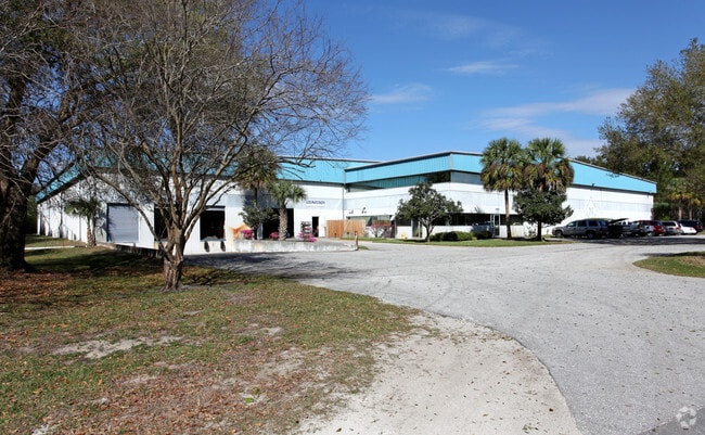
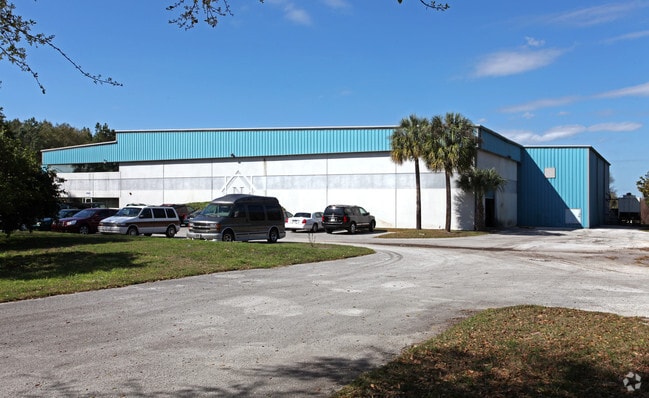
Property Record
21005 Obrien Rd, Groveland, FL 34736

NEARBY LISTINGS FOR SALE OR LEASE
Property Detail
21005 Obrien Rd
Orlando-Kissimmee-Sanford, FL
THE SOUTH 165 FEET OF THE SOUTHEAST 1/4 OF THE SOUTHWEST 1/4 LYING WEST OF OBRIEN ROAD OF SECTION 16 TOWNSHIP 21 SOUTH RANGE 25 EAST ORB 5939 PG 1323
21-21-25-0002-000-01700
Lake
Lightindustrial
Florida
2024
5
2026
25.12 AC
031206
Lake County
59,972 SF
Orlando
DEMOGRAPHICS near 21005 Obrien Rd
1 Mile
3 Mile
5 Mile
2024 Total Population
33
5,609
21,767
2029 Population
39
6,541
25,623
Pop Growth 2024-2029
+ 18.18%
+ 16.62%
+ 17.71%
Average Age
43
53
49
2024 Total Households
13
2,274
8,594
HH Growth 2024-2029
+ 15.38%
+ 16.36%
+ 17.38%
Median Household Inc
$38,499
$75,414
$76,237
Avg Household Size
2.40
2.20
2.40
2024 Avg HH Vehicles
3.00
2.00
2.00
Median Home Value
$250,000
$302,398
$291,792
Median Year Built
1978
2010
2005
Nearby Places
Map Layers
Map Styles
 Street
 Aerial
- Restaurants
- Banks
- Shops
- Fitness
- Groceries
PUBLIC TRANSPORTATION
AIRPORT
Orlando International
DRIVE
WALK
Distance
Orlando International
51 min
40.4 mi
Orlando Sanford International
DRIVE
WALK
Distance
Orlando Sanford International
69 min
48.2 mi
SALE & LEASE HISTORY
LISTING DATE
SALE/LEASE

Jul 13, 2020
For Sale
Nearby Properties
Address
Land Use
TOTAL SIZE
Lot Size
Zoning
Address
Land Use
TOTAL SIZE
Lot Size
Zoning
980,381 SF
89.73 AC
A
Address
Land Use
TOTAL SIZE
Lot Size
Zoning
877,798 SF
71.91 AC
PUD
Address
Land Use
TOTAL SIZE
Lot Size
Zoning
570,180 SF
45.30 AC
PUD
Address
Land Use
TOTAL SIZE
Lot Size
Zoning
425,048 SF
29.99 AC
MP
Address
Land Use
TOTAL SIZE
Lot Size
Zoning
707,178 SF
44.54 AC
PUD
Address
Land Use
TOTAL SIZE
Lot Size
Zoning
362,249 SF
100.59 AC
PUD
Address
Land Use
TOTAL SIZE
Lot Size
Zoning
43,769 SF
287.86 AC
C1
Address
Land Use
TOTAL SIZE
Lot Size
Zoning
202,028 SF
47.71 AC
PUD
Address
Land Use
TOTAL SIZE
Lot Size
Zoning
291,197 SF
17.47 AC
PUD
Address
Land Use
TOTAL SIZE
Lot Size
Zoning
250,800 SF
24.02 AC
PUD
Address
Land Use
TOTAL SIZE
Lot Size
Zoning
192,992 SF
20.66 AC
PUD
Address
Land Use
TOTAL SIZE
Lot Size
Zoning
195,697 SF
11.92 AC
PUD
Address
Land Use
TOTAL SIZE
Lot Size
Zoning
125,732 SF
20.19 AC
PUD
Address
Land Use
TOTAL SIZE
Lot Size
Zoning
65,244 SF
1.22 AC
Address
Land Use
TOTAL SIZE
Lot Size
Zoning
127,200 SF
10.54 AC
PUD
Address
Land Use
TOTAL SIZE
Lot Size
Zoning
116,737 SF
71.77 AC
MP
Address
Land Use
TOTAL SIZE
Lot Size
Zoning
125,956 SF
31.25 AC
PUD
Address
Land Use
TOTAL SIZE
Lot Size
Zoning
66.34 AC
Address
Land Use
TOTAL SIZE
Lot Size
Zoning
56.54 AC
PUD
Address
Land Use
TOTAL SIZE
Lot Size
Zoning
89,916 SF
10.72 AC
PUD
Address
Land Use
TOTAL SIZE
Lot Size
Zoning
41,283 SF
22.83 AC
MP
Address
Land Use
TOTAL SIZE
Lot Size
Zoning
48,772 SF
51.39 AC
LM
Address
Land Use
TOTAL SIZE
Lot Size
Zoning
46,302 SF
24.06 AC
HM
Address
Land Use
TOTAL SIZE
Lot Size
Zoning
67,562 SF
5.01 AC
Address
Land Use
TOTAL SIZE
Lot Size
Zoning
65,330 SF
3.89 AC
Address
Land Use
TOTAL SIZE
Lot Size
Zoning
71.86 AC
Address
Land Use
TOTAL SIZE
Lot Size
Zoning
69,000 SF
5.63 AC
PUD
Address
Land Use
TOTAL SIZE
Lot Size
Zoning
64,000 SF
5.31 AC
Address
Land Use
TOTAL SIZE
Lot Size
Zoning
8,030 SF
46.70 AC
C2
The World's #1 Commercial Real Estate Marketplace
Connect with us
© 2026 CoStar Group
The information above has been obtained from sources believed reliable. While we do not doubt its accuracy we have not verified it and make no guarantee, warranty or representation about it. It is your responsibility to independently confirm its accuracy and completeness. Any projections, opinions, assumptions, or estimates used are for example only and do not represent the current or future performance of the property. The value of this transaction to you depends on tax and other factors which should be evaluated by your tax, financial, and legal advisors. You and your advisors should conduct a careful, independent investigation of the property to determine to your satisfaction the suitability of the property for your needs.