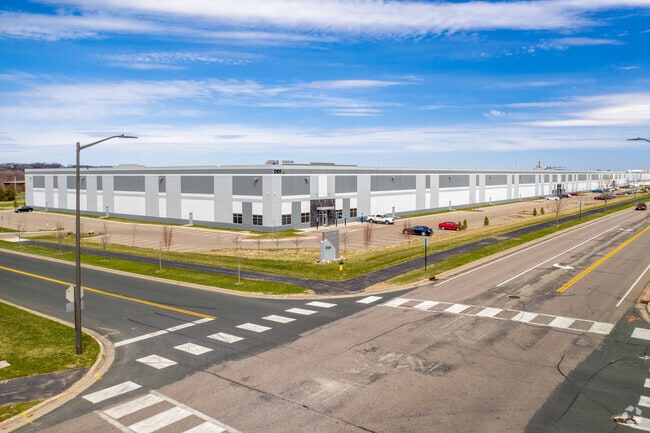
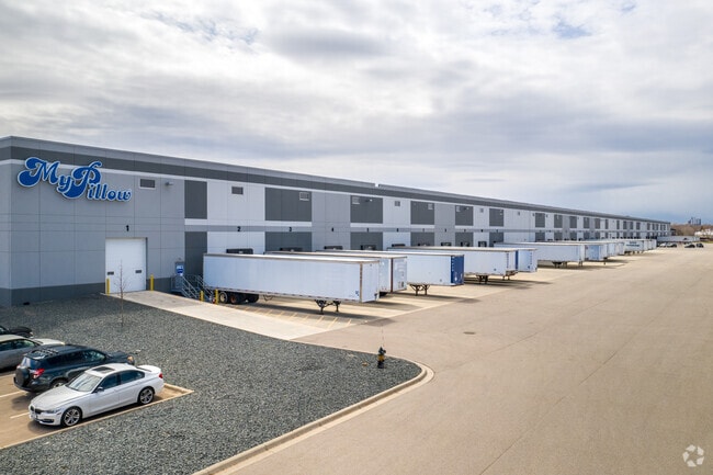
Property Record
2101 4Th Ave E, Shakopee, MN 55379


Current Lease Availabilities
Property Detail
2101 4Th Ave E
Minneapolis-St. Paul-Bloomington, MN-WI
The Land referred to herein below is situated in the County of Scott, State of Minnesota, and is des
27-456-001-0
Scott
Manufacturinglight
Minnesota
B and X Area of moderate flood hazard, usually the area between the limits of the 100-year and 500-year floods.
1
2025
24.09 AC
2025
Southwest
080303
Minneapolis/St Paul
374,700 SF
NEARBY LISTINGS FOR SALE OR LEASE
DEMOGRAPHICS near 2101 4Th Ave E
1 mile
3 mile
5 mile
2025 Total Population
8,101
45,733
110,707
2030 Population
8,423
46,947
113,263
Pop Growth 2025-2030
+ 3.97%
+ 2.65%
+ 2.31%
Average Age
37
38
39
2025 Total Households
3,237
15,734
40,210
HH Growth 2025-2030
+ 4.26%
+ 2.80%
+ 2.38%
Median Household Inc
$79,492
$107,148
$114,815
Avg Household Size
2.40
2.80
2.70
2025 Avg HH Vehicles
2.00
2.00
2.00
Median Home Value
$293,389
$387,932
$441,144
Median Year Built
1991
1998
1994
Nearby Places
Map Layers
Map Styles
 Street
 Aerial
Transit
 Traffic
 Biking
Places
Listings with unknown addresses are not visible on the map
- Restaurants
- Banks
- Shops
- Fitness
- Groceries
PUBLIC TRANSPORTATION
AIRPORT
Minneapolis-St Paul International/Wold-Chamberlain
Drive
Walk
Distance
Minneapolis-St Paul International/Wold-Chamberlain
30 min
20.5 mi
Freight Ports
Port Milwaukee
Drive
Walk
Distance
Port Milwaukee
399 min
357.6 mi
Nearby Properties
Address
Land Use
TOTAL SIZE
Lot Size
Zoning
Address
Land Use
TOTAL SIZE
Lot Size
Zoning
625,426 SF
40.47 AC
Address
Land Use
TOTAL SIZE
Lot Size
Zoning
66.08 AC
Address
Land Use
TOTAL SIZE
Lot Size
Zoning
475,471 SF
12.90 AC
Address
Land Use
TOTAL SIZE
Lot Size
Zoning
10.02 AC
Address
Land Use
TOTAL SIZE
Lot Size
Zoning
151,074 SF
17.27 AC
Address
Land Use
TOTAL SIZE
Lot Size
Zoning
1,008,768 SF
93.90 AC
Address
Land Use
TOTAL SIZE
Lot Size
Zoning
33.02 AC
Address
Land Use
TOTAL SIZE
Lot Size
Zoning
Address
Land Use
TOTAL SIZE
Lot Size
Zoning
600,000 SF
31.21 AC
Address
Land Use
TOTAL SIZE
Lot Size
Zoning
26.13 AC
Address
Land Use
TOTAL SIZE
Lot Size
Zoning
397,347 SF
28.62 AC
Address
Land Use
TOTAL SIZE
Lot Size
Zoning
691,276 SF
28.74 AC
Address
Land Use
TOTAL SIZE
Lot Size
Zoning
16.08 AC
Address
Land Use
TOTAL SIZE
Lot Size
Zoning
Address
Land Use
TOTAL SIZE
Lot Size
Zoning
51,272 SF
2.11 AC
Address
Land Use
TOTAL SIZE
Lot Size
Zoning
1.80 AC
Address
Land Use
TOTAL SIZE
Lot Size
Zoning
164,809 SF
7.28 AC
Address
Land Use
TOTAL SIZE
Lot Size
Zoning
198,754 SF
27.50 AC
Address
Land Use
TOTAL SIZE
Lot Size
Zoning
52,280 SF
12.15 AC
Address
Land Use
TOTAL SIZE
Lot Size
Zoning
497,443 SF
37.88 AC
Address
Land Use
TOTAL SIZE
Lot Size
Zoning
302,500 SF
23.79 AC
Address
Land Use
TOTAL SIZE
Lot Size
Zoning
Address
Land Use
TOTAL SIZE
Lot Size
Zoning
216,960 SF
19.58 AC
Address
Land Use
TOTAL SIZE
Lot Size
Zoning
191,395 SF
5.16 AC
Address
Land Use
TOTAL SIZE
Lot Size
Zoning
369,867 SF
22.19 AC
Address
Land Use
TOTAL SIZE
Lot Size
Zoning
299,600 SF
16.48 AC
Address
Land Use
TOTAL SIZE
Lot Size
Zoning
217,495 SF
22.77 AC
Address
Land Use
TOTAL SIZE
Lot Size
Zoning
109,720 SF
10.65 AC
Address
Land Use
TOTAL SIZE
Lot Size
Zoning
242,004 SF
16.54 AC
The World's #1 Commercial Real Estate Marketplace
Connect with us
© 2026 CoStar Group
The information above has been obtained from sources believed reliable. While we do not doubt its accuracy we have not verified it and make no guarantee, warranty or representation about it. It is your responsibility to independently confirm its accuracy and completeness. Any projections, opinions, assumptions, or estimates used are for example only and do not represent the current or future performance of the property. The value of this transaction to you depends on tax and other factors which should be evaluated by your tax, financial, and legal advisors. You and your advisors should conduct a careful, independent investigation of the property to determine to your satisfaction the suitability of the property for your needs.