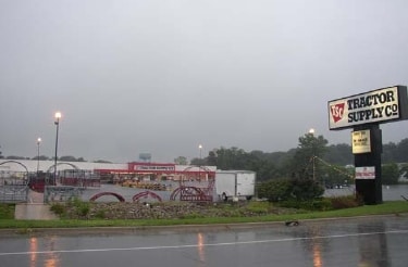
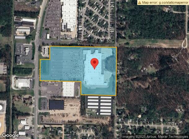
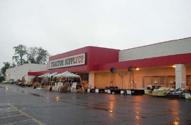
Property Record
2107 S 11Th St, Niles, MI 49120
NEARBY LISTINGS FOR SALE OR LEASE
Property Detail
2107 S 11Th St
11-14-0111-0007-13-6
COM AT E1/4 PST SEC 11 T8S R17W TH S00DEG41'00W 907.68' TH N88DEG43'39"W 666.18' TH N00DEG43'35"E 245.14' TH N88DEG43'03"W 772.62' TO E R/W LN M-51 TH NLY ON R/W LN TO A PT CHD BRGS01DEG44'56"W 165.11' & S00DEG43'06"W OF INT ELY R/W LN M-51 & THE E&W
Wholesaleoutletdiscountstore
Berrien
X
Michigan
18141C0086D
24.57 AC
2024
Michigan Southwest Area
2025
Other Market Areas
021000
Niles-Benton Harbor, MI
164,768 SF
DEMOGRAPHICS near 2107 S 11Th St
1 Mile
3 Mile
5 Mile
2024 Total Population
2,823
20,974
55,419
2029 Population
2,740
20,502
54,410
Pop Growth 2024-2029
(2.94%)
(2.25%)
(1.82%)
Average Age
40
41
42
2024 Total Households
1,084
8,480
22,691
HH Growth 2024-2029
(3.14%)
(2.42%)
(1.91%)
Median Household Inc
$60,302
$57,867
$71,446
Avg Household Size
2.40
2.40
2.40
2024 Avg HH Vehicles
2.00
2.00
2.00
Median Home Value
$139,679
$146,223
$175,844
Median Year Built
1968
1959
1972
Nearby Places
Map Layers
Map Styles
 Street
 Aerial
- Restaurants
- Banks
- Shops
- Fitness
- Groceries
PUBLIC TRANSPORTATION
COMMUTER RAIL
DRIVE
WALK
Distance
8 min
3.9 mi
South Bend Airport Station (South Shore Line - Northern Indiana Commuter Transportation District (South Shore Line))
DRIVE
WALK
Distance
South Bend Airport Station (South Shore Line - Northern Indiana Commuter Transportation District (South Shore Line))
22 min
9.7 mi
AIRPORT
South Bend International
DRIVE
WALK
Distance
South Bend International
30 min
15.5 mi
Nearby Properties
Address
Land Use
TOTAL SIZE
Lot Size
Zoning
Address
Land Use
TOTAL SIZE
Lot Size
Zoning
Address
Land Use
TOTAL SIZE
Lot Size
Zoning
33,936 SF
1.84 AC
GB
Address
Land Use
TOTAL SIZE
Lot Size
Zoning
74,516 SF
2.21 AC
MDR
Address
Land Use
TOTAL SIZE
Lot Size
Zoning
124,568 SF
11.40 AC
R-2
Address
Land Use
TOTAL SIZE
Lot Size
Zoning
42,200 SF
0.98 AC
OC
Address
Land Use
TOTAL SIZE
Lot Size
Zoning
135,152 SF
8.76 AC
GB
Address
Land Use
TOTAL SIZE
Lot Size
Zoning
58,689 SF
0.75 AC
LDR
Address
Land Use
TOTAL SIZE
Lot Size
Zoning
300,000 SF
65.30 AC
I
Address
Land Use
TOTAL SIZE
Lot Size
Zoning
74,375 SF
5.27 AC
RC
Address
Land Use
TOTAL SIZE
Lot Size
Zoning
26,140 SF
131 SF
Address
Land Use
TOTAL SIZE
Lot Size
Zoning
65,358 SF
6.02 AC
R-2
Address
Land Use
TOTAL SIZE
Lot Size
Zoning
49,914 SF
6.18 AC
GB
Address
Land Use
TOTAL SIZE
Lot Size
Zoning
52,528 SF
2.41 AC
Address
Land Use
TOTAL SIZE
Lot Size
Zoning
30,000 SF
1.03 AC
CB
Address
Land Use
TOTAL SIZE
Lot Size
Zoning
114,835 SF
27.11 AC
LDR
Address
Land Use
TOTAL SIZE
Lot Size
Zoning
61,402 SF
2.49 AC
MDR
Address
Land Use
TOTAL SIZE
Lot Size
Zoning
35,016 SF
3.50 AC
Address
Land Use
TOTAL SIZE
Lot Size
Zoning
5,075 SF
36.90 AC
R-3
Address
Land Use
TOTAL SIZE
Lot Size
Zoning
19,626 SF
3.10 AC
GB
Address
Land Use
TOTAL SIZE
Lot Size
Zoning
42,840 SF
1.65 AC
GB
Address
Land Use
TOTAL SIZE
Lot Size
Zoning
24,984 SF
5 AC
R-2
Address
Land Use
TOTAL SIZE
Lot Size
Zoning
97,905 SF
9.55 AC
MDR
Address
Land Use
TOTAL SIZE
Lot Size
Zoning
31,932 SF
0.90 AC
RC
Address
Land Use
TOTAL SIZE
Lot Size
Zoning
14,487 SF
2.43 AC
GB
Address
Land Use
TOTAL SIZE
Lot Size
Zoning
48,100 SF
5.10 AC
GB
Address
Land Use
TOTAL SIZE
Lot Size
Zoning
42,255 SF
2.61 AC
R-1B
Address
Land Use
TOTAL SIZE
Lot Size
Zoning
33,444 SF
1.70 AC
MDR
Address
Land Use
TOTAL SIZE
Lot Size
Zoning
113,964 SF
9.85 AC
GB
Address
Land Use
TOTAL SIZE
Lot Size
Zoning
61,128 SF
7.63 AC
GB
The World's #1 Commercial Real Estate Marketplace
Connect with us
© 2025 CoStar Group
The information above has been obtained from sources believed reliable. While we do not doubt its accuracy we have not verified it and make no guarantee, warranty or representation about it. It is your responsibility to independently confirm its accuracy and completeness. Any projections, opinions, assumptions, or estimates used are for example only and do not represent the current or future performance of the property. The value of this transaction to you depends on tax and other factors which should be evaluated by your tax, financial, and legal advisors. You and your advisors should conduct a careful, independent investigation of the property to determine to your satisfaction the suitability of the property for your needs.