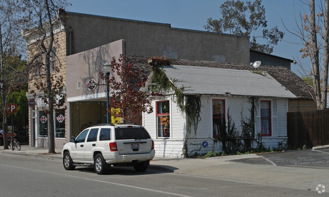
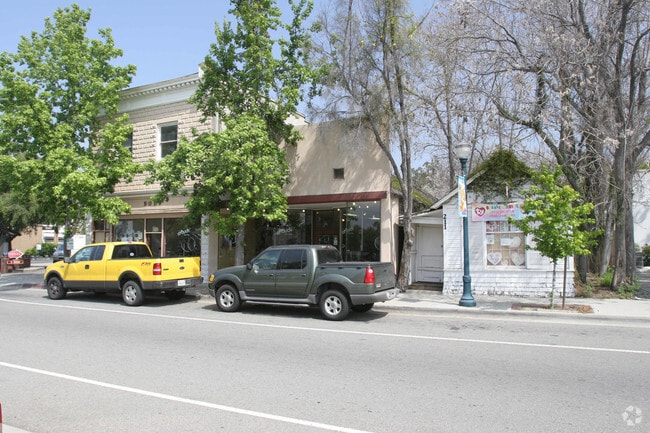
Property Record
211-219 W 1St St, Claremont, CA 91711

NEARBY LISTINGS FOR SALE OR LEASE
Property Detail
211-219 W 1St St
Los Angeles-Long Beach-Glendale, CA
Claremont
8313-019-016
CLAREMONT E 25 FT OF W 70 FT OF LOTS 8,9,10 AND 11 AND E 25 FT OF W 70 FT EX OF ST OF LOT 12 BLK 44
Storemultistory
Los Angeles
X
California
06037C1750F
8
2024
0.06 AC
2025
Eastern SGV
401902
Los Angeles
1,312 SF
DEMOGRAPHICS near 211-219 W 1St St
1 Mile
3 Mile
5 Mile
2024 Total Population
22,693
166,672
402,808
2029 Population
22,286
164,609
399,034
Pop Growth 2024-2029
(1.79%)
(1.24%)
(0.94%)
Average Age
37
38
38
2024 Total Households
6,663
51,720
123,616
HH Growth 2024-2029
(2.15%)
(1.35%)
(0.96%)
Median Household Inc
$83,717
$79,754
$80,432
Avg Household Size
2.50
3.00
3.10
2024 Avg HH Vehicles
2.00
2.00
2.00
Median Home Value
$728,125
$618,987
$623,280
Median Year Built
1962
1968
1970
Nearby Places
Map Layers
Map Styles
 Street
 Aerial
- Restaurants
- Banks
- Shops
- Fitness
- Groceries
PUBLIC TRANSPORTATION
COMMUTER RAIL
Claremont (San Bernardino Line - Southern California Regional Rail Authority (Metrolink))
DRIVE
WALK
Distance
Claremont (San Bernardino Line - Southern California Regional Rail Authority (Metrolink))
1 min
2 min
0.2 mi
Montclair (San Bernardino Line - Southern California Regional Rail Authority (Metrolink))
DRIVE
WALK
Distance
Montclair (San Bernardino Line - Southern California Regional Rail Authority (Metrolink))
5 min
2.0 mi
AIRPORT
Ontario International
DRIVE
WALK
Distance
Ontario International
14 min
9.1 mi
Freight Ports
Port of Long Beach
DRIVE
WALK
Distance
Port of Long Beach
60 min
46.9 mi
Nearby Properties
Address
Land Use
TOTAL SIZE
Lot Size
Zoning
Address
Land Use
TOTAL SIZE
Lot Size
Zoning
491,876 SF
22.46 AC
Address
Land Use
TOTAL SIZE
Lot Size
Zoning
788,560 SF
36.86 AC
Address
Land Use
TOTAL SIZE
Lot Size
Zoning
672,929 SF
90.10 AC
CLE*
Address
Land Use
TOTAL SIZE
Lot Size
Zoning
167,013 SF
30.60 AC
CLE*
Address
Land Use
TOTAL SIZE
Lot Size
Zoning
126,533 SF
19.51 AC
Address
Land Use
TOTAL SIZE
Lot Size
Zoning
43,129 SF
21.20 AC
CLE*
Address
Land Use
TOTAL SIZE
Lot Size
Zoning
134,182 SF
1.56 AC
CLE*
Address
Land Use
TOTAL SIZE
Lot Size
Zoning
167,512 SF
8.35 AC
Address
Land Use
TOTAL SIZE
Lot Size
Zoning
296,080 SF
14.57 AC
CLRM2000*
Address
Land Use
TOTAL SIZE
Lot Size
Zoning
224,998 SF
2.61 AC
CLI*
Address
Land Use
TOTAL SIZE
Lot Size
Zoning
120,943 SF
CLE*
Address
Land Use
TOTAL SIZE
Lot Size
Zoning
250,772 SF
23.93 AC
CLE*
Address
Land Use
TOTAL SIZE
Lot Size
Zoning
142,438 SF
8.99 AC
CLRM
Address
Land Use
TOTAL SIZE
Lot Size
Zoning
538,944 SF
20.73 AC
Address
Land Use
TOTAL SIZE
Lot Size
Zoning
125,663 SF
7.04 AC
Address
Land Use
TOTAL SIZE
Lot Size
Zoning
125,388 SF
8.88 AC
LVPR15A*
Address
Land Use
TOTAL SIZE
Lot Size
Zoning
218,376 SF
12.50 AC
Address
Land Use
TOTAL SIZE
Lot Size
Zoning
196,175 SF
9.14 AC
POM2*
Address
Land Use
TOTAL SIZE
Lot Size
Zoning
198,575 SF
7.72 AC
LUCPD*
Address
Land Use
TOTAL SIZE
Lot Size
Zoning
176,482 SF
2.31 AC
POMU
Address
Land Use
TOTAL SIZE
Lot Size
Zoning
157,736 SF
8.14 AC
POC1
Address
Land Use
TOTAL SIZE
Lot Size
Zoning
272,258 SF
1.41 AC
POMU
Address
Land Use
TOTAL SIZE
Lot Size
Zoning
1.86 AC
Address
Land Use
TOTAL SIZE
Lot Size
Zoning
99,508 SF
16.74 AC
CLE*
Address
Land Use
TOTAL SIZE
Lot Size
Zoning
175,000 SF
15.24 AC
Address
Land Use
TOTAL SIZE
Lot Size
Zoning
107,525 SF
POR4*
Address
Land Use
TOTAL SIZE
Lot Size
Zoning
100,815 SF
3.96 AC
Address
Land Use
TOTAL SIZE
Lot Size
Zoning
180,868 SF
8.24 AC
Address
Land Use
TOTAL SIZE
Lot Size
Zoning
119,109 SF
10.39 AC
CLE*
The World's #1 Commercial Real Estate Marketplace
Connect with us
© 2025 CoStar Group
The information above has been obtained from sources believed reliable. While we do not doubt its accuracy we have not verified it and make no guarantee, warranty or representation about it. It is your responsibility to independently confirm its accuracy and completeness. Any projections, opinions, assumptions, or estimates used are for example only and do not represent the current or future performance of the property. The value of this transaction to you depends on tax and other factors which should be evaluated by your tax, financial, and legal advisors. You and your advisors should conduct a careful, independent investigation of the property to determine to your satisfaction the suitability of the property for your needs.