Property Record
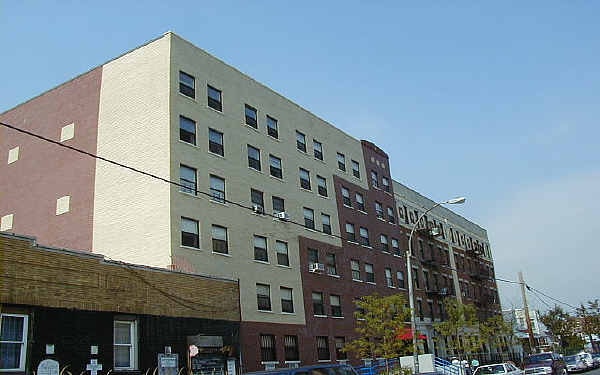
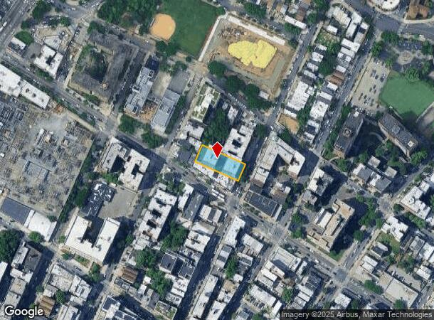
2111 Hughes Ave, Bronx, NY 10457
NEARBY LISTINGS FOR SALE OR LEASE
Property Detail
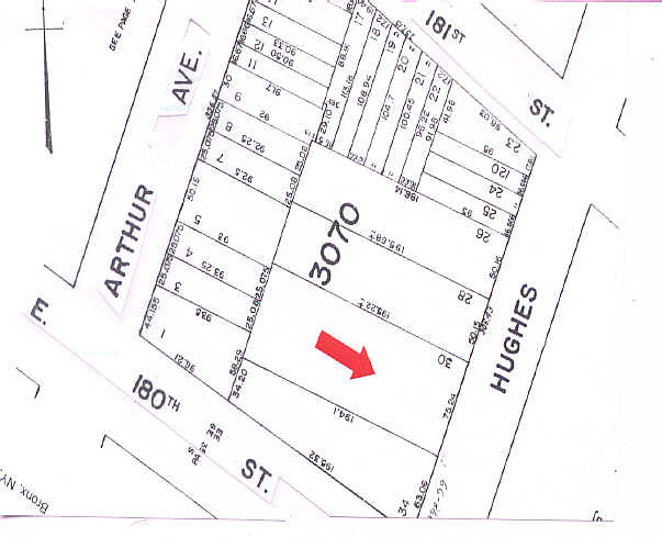
2111 Hughes Ave
03070-0030
Map Of Land Known As The Samuel Ryer Hom
Apartment
Bronx
X
New York
3604970082F
30
0
0.34 AC
2025
Belmont
037300
Westchester/So Connecticut
56,340 SF
New York-Jersey City-White Plains, NY-NJ
DEMOGRAPHICS near 2111 Hughes Ave
1 Mile
3 Mile
5 Mile
2024 Total Population
176,311
1,282,091
1,972,570
2029 Population
165,878
1,190,548
1,831,065
Pop Growth 2024-2029
(5.92%)
(7.14%)
(7.17%)
Average Age
36
38
39
2024 Total Households
59,622
454,060
728,199
HH Growth 2024-2029
(6.67%)
(7.77%)
(7.64%)
Median Household Inc
$34,255
$42,459
$46,760
Avg Household Size
2.70
2.70
2.50
2024 Avg HH Vehicles
.00
.00
1.00
Median Home Value
$453,669
$504,114
$542,455
Median Year Built
1949
1949
1952
Nearby Places
Map Layers
Map Styles
 Street
 Aerial
- Restaurants
- Banks
- Shops
- Fitness
- Groceries
PUBLIC TRANSPORTATION
TRANSIT/SUBWAY
182-183 Streets (B - New York MTA Subway (The Subway), D - New York MTA Subway (The Subway))
DRIVE
WALK
Distance
182-183 Streets (B - New York MTA Subway (The Subway), D - New York MTA Subway (The Subway))
3 min
17 min
0.9 mi
Tremont Avenue (B - New York MTA Subway (The Subway), D - New York MTA Subway (The Subway))
DRIVE
WALK
Distance
Tremont Avenue (B - New York MTA Subway (The Subway), D - New York MTA Subway (The Subway))
3 min
18 min
1.0 mi
West Farms Square-East Tremont Avenue (2 - New York MTA Subway (The Subway), 5 - New York MTA Subway (The Subway))
DRIVE
WALK
Distance
West Farms Square-East Tremont Avenue (2 - New York MTA Subway (The Subway), 5 - New York MTA Subway (The Subway))
2 min
18 min
1.0 mi
174 Street (2 - New York MTA Subway (The Subway), 5 - New York MTA Subway (The Subway))
DRIVE
WALK
Distance
174 Street (2 - New York MTA Subway (The Subway), 5 - New York MTA Subway (The Subway))
3 min
20 min
1.0 mi
COMMUTER RAIL
Tremont Station (Harlem Line - Metro-North Commuter Railroad Company (Metro-North))
DRIVE
WALK
Distance
Tremont Station (Harlem Line - Metro-North Commuter Railroad Company (Metro-North))
2 min
12 min
0.6 mi
Fordham Station (Harlem Line - Metro-North Commuter Railroad Company (Metro-North), New Haven Line - Metro-North Commuter Railroad Company (Metro-North))
DRIVE
WALK
Distance
Fordham Station (Harlem Line - Metro-North Commuter Railroad Company (Metro-North), New Haven Line - Metro-North Commuter Railroad Company (Metro-North))
2 min
17 min
0.9 mi
AIRPORT
LaGuardia
DRIVE
WALK
Distance
LaGuardia
21 min
10.2 mi
John F Kennedy International
DRIVE
WALK
Distance
John F Kennedy International
28 min
19.2 mi
Westchester County
DRIVE
WALK
Distance
Westchester County
38 min
23.3 mi
Freight Ports
NY - Red Hook Container Terminal
DRIVE
WALK
Distance
NY - Red Hook Container Terminal
34 min
18.3 mi
Nearby Properties
Address
Land Use
TOTAL SIZE
Lot Size
Zoning
Address
Land Use
TOTAL SIZE
Lot Size
Zoning
3,693,539 SF
8.37 AC
R8
Address
Land Use
TOTAL SIZE
Lot Size
Zoning
1,299,700 SF
29.82 AC
R6
Address
Land Use
TOTAL SIZE
Lot Size
Zoning
550,000 SF
8.75 AC
M1-1
Address
Land Use
TOTAL SIZE
Lot Size
Zoning
1,743,584 SF
77.87 AC
R6
Address
Land Use
TOTAL SIZE
Lot Size
Zoning
1,427,393 SF
39.94 AC
R4
Address
Land Use
TOTAL SIZE
Lot Size
Zoning
1,651,267 SF
1.23 AC
R8
Address
Land Use
TOTAL SIZE
Lot Size
Zoning
481,172 SF
205.58 AC
PARK
Address
Land Use
TOTAL SIZE
Lot Size
Zoning
895,256 SF
8.32 AC
R7-1
Address
Land Use
TOTAL SIZE
Lot Size
Zoning
891,040 SF
5.63 AC
R8
Address
Land Use
TOTAL SIZE
Lot Size
Zoning
0.36 AC
R8
Address
Land Use
TOTAL SIZE
Lot Size
Zoning
1,311,800 SF
9.89 AC
C4-4
Address
Land Use
TOTAL SIZE
Lot Size
Zoning
23.12 AC
PARK
Address
Land Use
TOTAL SIZE
Lot Size
Zoning
1,237,424 SF
21.25 AC
R6
Address
Land Use
TOTAL SIZE
Lot Size
Zoning
1,012,000 SF
7.79 AC
R6
Address
Land Use
TOTAL SIZE
Lot Size
Zoning
485,484 SF
39.63 AC
R5
Address
Land Use
TOTAL SIZE
Lot Size
Zoning
204,200 SF
1.68 AC
R7-1
Address
Land Use
TOTAL SIZE
Lot Size
Zoning
807,327 SF
0.60 AC
R8
Address
Land Use
TOTAL SIZE
Lot Size
Zoning
667,405 SF
5.51 AC
R6
Address
Land Use
TOTAL SIZE
Lot Size
Zoning
2,531,670 SF
17.15 AC
R7-2
Address
Land Use
TOTAL SIZE
Lot Size
Zoning
390,750 SF
265 AC
PARK
Address
Land Use
TOTAL SIZE
Lot Size
Zoning
317,485 SF
1.57 AC
R8
Address
Land Use
TOTAL SIZE
Lot Size
Zoning
43.65 AC
PARK
Address
Land Use
TOTAL SIZE
Lot Size
Zoning
631,237 SF
30.93 AC
R5
Address
Land Use
TOTAL SIZE
Lot Size
Zoning
707,353 SF
29.34 AC
R6
Address
Land Use
TOTAL SIZE
Lot Size
Zoning
480,769 SF
1.21 AC
R8
Address
Land Use
TOTAL SIZE
Lot Size
Zoning
1,392,950 SF
19.67 AC
M2-1
Address
Land Use
TOTAL SIZE
Lot Size
Zoning
851,821 SF
7.95 AC
R4
Address
Land Use
TOTAL SIZE
Lot Size
Zoning
259.87 AC
PARK
Address
Land Use
TOTAL SIZE
Lot Size
Zoning
491,007 SF
11.85 AC
M3-1
Address
Land Use
TOTAL SIZE
Lot Size
Zoning
286,481 SF
0.62 AC
C6-2
The World's #1 Commercial Real Estate Marketplace
Connect with us
© 2025 CoStar Group
The information above has been obtained from sources believed reliable. While we do not doubt its accuracy we have not verified it and make no guarantee, warranty or representation about it. It is your responsibility to independently confirm its accuracy and completeness. Any projections, opinions, assumptions, or estimates used are for example only and do not represent the current or future performance of the property. The value of this transaction to you depends on tax and other factors which should be evaluated by your tax, financial, and legal advisors. You and your advisors should conduct a careful, independent investigation of the property to determine to your satisfaction the suitability of the property for your needs.