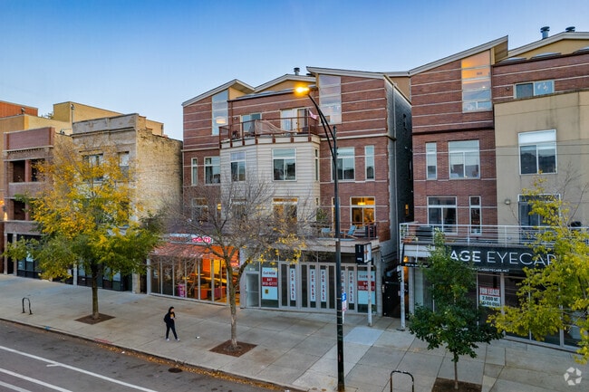
Property Record
2121 W Division St, Chicago, IL 60622

NEARBY LISTINGS FOR SALE OR LEASE
Property Detail
2121 W Division St
17-06-302-046-1005
Highpoint West Condo
Condominium
Cook
X
Illinois
17031C0418J
7-9
2023
0.08 AC
2025
Ukrainian Village
242300
Chicago
2,200 SF
Chicago-Naperville-Elgin, IL-IN
DEMOGRAPHICS near 2121 W Division St
1 mile
3 mile
5 mile
2024 Total Population
69,763
524,725
1,164,625
2029 Population
66,564
507,463
1,114,817
Pop Growth 2024-2029
(4.59%)
(3.29%)
(4.28%)
Average Age
35
36
37
2024 Total Households
33,202
257,233
535,308
HH Growth 2024-2029
(4.98%)
(3.18%)
(3.96%)
Median Household Inc
$120,886
$103,068
$86,856
Avg Household Size
2.10
2.00
2.10
2024 Avg HH Vehicles
1.00
1.00
1.00
Median Home Value
$599,190
$510,760
$430,487
Median Year Built
1949
1970
1958
Nearby Places
Map Layers
Map Styles
 Street
 Aerial
Transit
 Traffic
 Biking
Places
Listings with unknown addresses are not visible on the map
- Restaurants
- Banks
- Shops
- Fitness
- Groceries
PUBLIC TRANSPORTATION
TRANSIT/SUBWAY
Damen Station (Blue Line) (Blue Line - Chicago Transit Authority "L" Trains (The "L"))
Drive
Walk
Distance
Damen Station (Blue Line) (Blue Line - Chicago Transit Authority "L" Trains (The "L"))
3 min
12 min
0.6 mi
Division Station (Blue Line - Chicago Transit Authority "L" Trains (The "L"))
Drive
Walk
Distance
Division Station (Blue Line - Chicago Transit Authority "L" Trains (The "L"))
2 min
15 min
0.8 mi
COMMUTER RAIL
Clybourn Station (Union Pacific North Line - Northeast Illinois Regional Commuter Railroad (Metra), Union Pacific Northwest Line - Northeast Illinois Regional Commuter Railroad (Metra))
Drive
Walk
Distance
Clybourn Station (Union Pacific North Line - Northeast Illinois Regional Commuter Railroad (Metra), Union Pacific Northwest Line - Northeast Illinois Regional Commuter Railroad (Metra))
4 min
1.7 mi
Western Avenue Station (MD-N/MD-W/NCS) (Milwaukee District North Line - Northeast Illinois Regional Commuter Railroad (Metra), Milwaukee District West Line - Northeast Illinois Regional Commuter Railroad (Metra), North Central Service - Northeast Illinois Regional Commuter Railroad (Metra))
Drive
Walk
Distance
Western Avenue Station (MD-N/MD-W/NCS) (Milwaukee District North Line - Northeast Illinois Regional Commuter Railroad (Metra), Milwaukee District West Line - Northeast Illinois Regional Commuter Railroad (Metra), North Central Service - Northeast Illinois Regional Commuter Railroad (Metra))
4 min
1.7 mi
AIRPORT
Chicago Midway International
Drive
Walk
Distance
Chicago Midway International
20 min
10.6 mi
Chicago O'Hare International
Drive
Walk
Distance
Chicago O'Hare International
25 min
15.0 mi
SALE & LEASE HISTORY
LISTING DATE
SALE/LEASE

May 15, 2018
For Sale
Jun 27, 2017
For Sale
Jan 24, 2018
For Sale
Jan 17, 2018
For Lease
Aug 09, 2018
For Sale
Aug 08, 2018
For Sale
Aug 04, 2020
For Lease
Apr 15, 2024
For Sale
Nearby Properties
Address
Land Use
TOTAL SIZE
Lot Size
Zoning
Address
Land Use
TOTAL SIZE
Lot Size
Zoning
4,667,723 SF
2.94 AC
DC-16
Address
Land Use
TOTAL SIZE
Lot Size
Zoning
1,546,909 SF
0.98 AC
PD 1369
Address
Land Use
TOTAL SIZE
Lot Size
Zoning
1,496,448 SF
2 AC
PD 376
Address
Land Use
TOTAL SIZE
Lot Size
Zoning
1,396,750 SF
4.09 AC
PD 98
Address
Land Use
TOTAL SIZE
Lot Size
Zoning
1,362,475 SF
1.97 AC
PD 1226
Address
Land Use
TOTAL SIZE
Lot Size
Zoning
4,296,046 SF
6.15 AC
DC-16
Address
Land Use
TOTAL SIZE
Lot Size
Zoning
3,914,400 SF
5.70 AC
DC-16
Address
Land Use
TOTAL SIZE
Lot Size
Zoning
1,810,145 SF
1.03 AC
PD 365
Address
Land Use
TOTAL SIZE
Lot Size
Zoning
0.82 AC
PD 1115
Address
Land Use
TOTAL SIZE
Lot Size
Zoning
0.88 AC
DC-16,PD 9
Address
Land Use
TOTAL SIZE
Lot Size
Zoning
2,750,656 SF
6.29 AC
PD 1065
Address
Land Use
TOTAL SIZE
Lot Size
Zoning
831,084 SF
2.05 AC
PD 316
Address
Land Use
TOTAL SIZE
Lot Size
Zoning
1,888,207 SF
2.03 AC
PD 264
Address
Land Use
TOTAL SIZE
Lot Size
Zoning
1,600,546 SF
1.04 AC
PD 191
Address
Land Use
TOTAL SIZE
Lot Size
Zoning
1,231,710 SF
2.01 AC
PD 27
Address
Land Use
TOTAL SIZE
Lot Size
Zoning
2,429,909 SF
2.93 AC
PD 882
Address
Land Use
TOTAL SIZE
Lot Size
Zoning
2,456,900 SF
0.96 AC
PD 256
Address
Land Use
TOTAL SIZE
Lot Size
Zoning
2,612,517 SF
1.28 AC
PD 256
Address
Land Use
TOTAL SIZE
Lot Size
Zoning
1.23 AC
PD 291
Address
Land Use
TOTAL SIZE
Lot Size
Zoning
1,502,279 SF
3.79 AC
PD 98
Address
Land Use
TOTAL SIZE
Lot Size
Zoning
1,559,966 SF
1.38 AC
DC-12
Address
Land Use
TOTAL SIZE
Lot Size
Zoning
1,316,385 SF
0.76 AC
PD 381
Address
Land Use
TOTAL SIZE
Lot Size
Zoning
1,571,900 SF
0.59 AC
PD 382
Address
Land Use
TOTAL SIZE
Lot Size
Zoning
1,578,363 SF
2.62 AC
DX-12
Address
Land Use
TOTAL SIZE
Lot Size
Zoning
1,051,000 SF
0.93 AC
PD 325
Address
Land Use
TOTAL SIZE
Lot Size
Zoning
0.61 AC
PD 824
Address
Land Use
TOTAL SIZE
Lot Size
Zoning
1.02 AC
PD 325
Address
Land Use
TOTAL SIZE
Lot Size
Zoning
0.35 AC
PD 325
Address
Land Use
TOTAL SIZE
Lot Size
Zoning
1,661,783 SF
0.56 AC
PD 500
Address
Land Use
TOTAL SIZE
Lot Size
Zoning
775,852 SF
1.72 AC
PD 27
The World's #1 Commercial Real Estate Marketplace
Connect with us
© 2026 CoStar Group
The information above has been obtained from sources believed reliable. While we do not doubt its accuracy we have not verified it and make no guarantee, warranty or representation about it. It is your responsibility to independently confirm its accuracy and completeness. Any projections, opinions, assumptions, or estimates used are for example only and do not represent the current or future performance of the property. The value of this transaction to you depends on tax and other factors which should be evaluated by your tax, financial, and legal advisors. You and your advisors should conduct a careful, independent investigation of the property to determine to your satisfaction the suitability of the property for your needs.