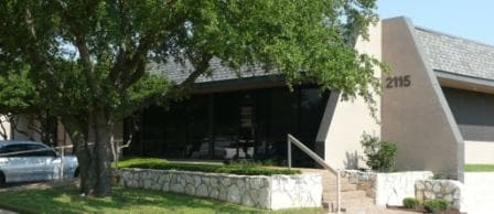
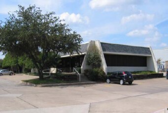
Property Record
2115 Teakwood Ln, Plano, TX 75075


Current Lease Availabilities
Property Detail
2115 Teakwood Ln
R-0181-001-0020-1
CUSTER PARKWAY PROFESSIONAL CENTER, BLK A, LOT 2
Officebuilding
COLLIN
O-M
Texas
B and X Area of moderate flood hazard, usually the area between the limits of the 100-year and 500-year floods.
2
2025
0.98 AC
2025
Plano
031627
Dallas/Ft Worth
10,125 SF
Dallas-Fort Worth-Arlington, TX
NEARBY LISTINGS FOR SALE OR LEASE
DEMOGRAPHICS near 2115 Teakwood Ln
1 mile
3 mile
5 mile
2025 Total Population
15,762
142,385
366,599
2030 Population
17,739
161,232
412,163
Pop Growth 2025-2030
+ 12.54%
+ 13.24%
+ 12.43%
Average Age
44
41
40
2025 Total Households
6,030
56,375
143,246
HH Growth 2025-2030
+ 12.72%
+ 13.56%
+ 12.84%
Median Household Inc
$126,261
$102,515
$106,332
Avg Household Size
2.60
2.50
2.50
2025 Avg HH Vehicles
2.00
2.00
2.00
Median Home Value
$428,116
$443,840
$490,410
Median Year Built
1977
1986
1991
Nearby Places
Map Layers
Map Styles
 Street
 Aerial
Layers
 Traffic
 Biking
Places
Listings with unknown addresses are not visible on the map
- Restaurants
- Banks
- Shops
- Fitness
- Groceries
PUBLIC TRANSPORTATION
AIRPORT
Dallas Love Field
Drive
Walk
Distance
Dallas Love Field
32 min
22.8 mi
Dallas-Fort Worth International
Drive
Walk
Distance
Dallas-Fort Worth International
35 min
28.0 mi
Freight Ports
Port of Shreveport
Drive
Walk
Distance
Port of Shreveport
228 min
209.0 mi
Nearby Properties
Address
Land Use
TOTAL SIZE
Lot Size
Zoning
Address
Land Use
TOTAL SIZE
Lot Size
Zoning
1,049,441 SF
Address
Land Use
TOTAL SIZE
Lot Size
Zoning
1,105,509 SF
92.46 AC
A
Address
Land Use
TOTAL SIZE
Lot Size
Zoning
659,402 SF
24.39 AC
O-M
Address
Land Use
TOTAL SIZE
Lot Size
Zoning
606,071 SF
64.75 AC
SFR
Address
Land Use
TOTAL SIZE
Lot Size
Zoning
341,492 SF
25.20 AC
SFR
Address
Land Use
TOTAL SIZE
Lot Size
Zoning
442,484 SF
APTS
Address
Land Use
TOTAL SIZE
Lot Size
Zoning
430,618 SF
11.33 AC
MF-H
Address
Land Use
TOTAL SIZE
Lot Size
Zoning
394,287 SF
14.96 AC
Address
Land Use
TOTAL SIZE
Lot Size
Zoning
507,693 SF
32.50 AC
MFL
Address
Land Use
TOTAL SIZE
Lot Size
Zoning
451,672 SF
23.81 AC
LI-1
Address
Land Use
TOTAL SIZE
Lot Size
Zoning
509,566 SF
34.05 AC
PD
Address
Land Use
TOTAL SIZE
Lot Size
Zoning
289,093 SF
8.87 AC
R/O-2
Address
Land Use
TOTAL SIZE
Lot Size
Zoning
284,830 SF
2.98 AC
Address
Land Use
TOTAL SIZE
Lot Size
Zoning
421,532 SF
4.29 AC
Address
Land Use
TOTAL SIZE
Lot Size
Zoning
308,854 SF
16.62 AC
Address
Land Use
TOTAL SIZE
Lot Size
Zoning
445,959 SF
4.55 AC
MF-E
Address
Land Use
TOTAL SIZE
Lot Size
Zoning
64.94 AC
Address
Land Use
TOTAL SIZE
Lot Size
Zoning
460,233 SF
10.31 AC
CC
Address
Land Use
TOTAL SIZE
Lot Size
Zoning
408,256 SF
27.66 AC
MF-M
Address
Land Use
TOTAL SIZE
Lot Size
Zoning
260,608 SF
18.68 AC
COMM
Address
Land Use
TOTAL SIZE
Lot Size
Zoning
400,049 SF
34.67 AC
MF-L
Address
Land Use
TOTAL SIZE
Lot Size
Zoning
457,656 SF
23.19 AC
MF-H
Address
Land Use
TOTAL SIZE
Lot Size
Zoning
297,331 SF
3.77 AC
Address
Land Use
TOTAL SIZE
Lot Size
Zoning
253,268 SF
4.54 AC
LC
Address
Land Use
TOTAL SIZE
Lot Size
Zoning
213,415 SF
16.94 AC
Address
Land Use
TOTAL SIZE
Lot Size
Zoning
381,372 SF
18.72 AC
MF-3
Address
Land Use
TOTAL SIZE
Lot Size
Zoning
326,481 SF
2.94 AC
BG
Address
Land Use
TOTAL SIZE
Lot Size
Zoning
299,130 SF
14.73 AC
R/O-M
Address
Land Use
TOTAL SIZE
Lot Size
Zoning
282,695 SF
3.32 AC
Address
Land Use
TOTAL SIZE
Lot Size
Zoning
340,812 SF
5.34 AC
R/0-M
The World's #1 Commercial Real Estate Marketplace
Connect with us
© 2026 CoStar Group
The information above has been obtained from sources believed reliable. While we do not doubt its accuracy we have not verified it and make no guarantee, warranty or representation about it. It is your responsibility to independently confirm its accuracy and completeness. Any projections, opinions, assumptions, or estimates used are for example only and do not represent the current or future performance of the property. The value of this transaction to you depends on tax and other factors which should be evaluated by your tax, financial, and legal advisors. You and your advisors should conduct a careful, independent investigation of the property to determine to your satisfaction the suitability of the property for your needs.