Property Record
2120 Citygate Dr, Columbus, OH 43219


NEARBY LISTINGS FOR SALE OR LEASE
Property Detail
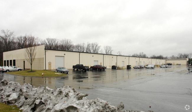
2120 Citygate Dr
010-265872
D J Land Developers Ltd
Warehouse
2120-2176 CITYGATE DR R17 T1 1/4T3 11.690 ACRES
X
Franklin
39049C0193K
Ohio
2024
11.69 AC
2024
N Central Columbus
007550
Columbus
75,635 SF
Columbus, OH
DEMOGRAPHICS near 2120 Citygate Dr
1 Mile
3 Mile
5 Mile
2024 Total Population
8,570
77,316
311,857
2029 Population
8,597
77,600
313,346
Pop Growth 2024-2029
+ 0.32%
+ 0.37%
+ 0.48%
Average Age
34
37
36
2024 Total Households
3,303
29,946
126,447
HH Growth 2024-2029
+ 0.42%
+ 0.36%
+ 0.50%
Median Household Inc
$53,360
$52,630
$53,621
Avg Household Size
2.50
2.50
2.40
2024 Avg HH Vehicles
2.00
2.00
2.00
Median Home Value
$173,472
$190,573
$215,225
Median Year Built
1995
1972
1969
Nearby Places
Map Layers
Map Styles
 Street
 Aerial
- Restaurants
- Banks
- Shops
- Fitness
- Groceries
PUBLIC TRANSPORTATION
AIRPORT
John Glenn Columbus International
DRIVE
WALK
Distance
John Glenn Columbus International
6 min
2.5 mi
Rickenbacker International
DRIVE
WALK
Distance
Rickenbacker International
25 min
15.6 mi
Freight Ports
Port of Toledo
DRIVE
WALK
Distance
Port of Toledo
185 min
145.4 mi
SALE & LEASE HISTORY
LISTING DATE
SALE/LEASE

Sep 25, 2016
For Lease
Mar 21, 2017
For Lease
Nearby Properties
Address
Land Use
TOTAL SIZE
Lot Size
Zoning
Address
Land Use
TOTAL SIZE
Lot Size
Zoning
316,415 SF
415.78 AC
Address
Land Use
TOTAL SIZE
Lot Size
Zoning
1,256,678 SF
1,292.62 AC
Address
Land Use
TOTAL SIZE
Lot Size
Zoning
2,299,970 SF
60.76 AC
Address
Land Use
TOTAL SIZE
Lot Size
Zoning
Address
Land Use
TOTAL SIZE
Lot Size
Zoning
1,935,173 SF
202.04 AC
Address
Land Use
TOTAL SIZE
Lot Size
Zoning
529,035 SF
37.56 AC
Address
Land Use
TOTAL SIZE
Lot Size
Zoning
449,494 SF
9.75 AC
Address
Land Use
TOTAL SIZE
Lot Size
Zoning
284,481 SF
94.09 AC
Address
Land Use
TOTAL SIZE
Lot Size
Zoning
570,003 SF
29.71 AC
Address
Land Use
TOTAL SIZE
Lot Size
Zoning
770,975 SF
64.63 AC
Address
Land Use
TOTAL SIZE
Lot Size
Zoning
516,485 SF
50.03 AC
Address
Land Use
TOTAL SIZE
Lot Size
Zoning
329,049 SF
38.53 AC
Address
Land Use
TOTAL SIZE
Lot Size
Zoning
242,064 SF
18.02 AC
Address
Land Use
TOTAL SIZE
Lot Size
Zoning
240,432 SF
16.59 AC
Address
Land Use
TOTAL SIZE
Lot Size
Zoning
150,424 SF
26.82 AC
Address
Land Use
TOTAL SIZE
Lot Size
Zoning
537,537 SF
77.62 AC
Address
Land Use
TOTAL SIZE
Lot Size
Zoning
299,220 SF
29.68 AC
Address
Land Use
TOTAL SIZE
Lot Size
Zoning
183,352 SF
55.41 AC
Address
Land Use
TOTAL SIZE
Lot Size
Zoning
214,424 SF
18.57 AC
Address
Land Use
TOTAL SIZE
Lot Size
Zoning
282,035 SF
29.29 AC
Address
Land Use
TOTAL SIZE
Lot Size
Zoning
88,068 SF
15.43 AC
Address
Land Use
TOTAL SIZE
Lot Size
Zoning
668,209 SF
61.10 AC
Address
Land Use
TOTAL SIZE
Lot Size
Zoning
274,272 SF
6.45 AC
Address
Land Use
TOTAL SIZE
Lot Size
Zoning
165,944 SF
14.21 AC
Address
Land Use
TOTAL SIZE
Lot Size
Zoning
332,616 SF
26.90 AC
Address
Land Use
TOTAL SIZE
Lot Size
Zoning
209,542 SF
27.50 AC
Address
Land Use
TOTAL SIZE
Lot Size
Zoning
331,458 SF
15.37 AC
Address
Land Use
TOTAL SIZE
Lot Size
Zoning
42,596 SF
37.05 AC
Address
Land Use
TOTAL SIZE
Lot Size
Zoning
67,166 SF
11.03 AC
Address
Land Use
TOTAL SIZE
Lot Size
Zoning
500,376 SF
3 AC
The World's #1 Commercial Real Estate Marketplace
Connect with us
© 2025 CoStar Group
The information above has been obtained from sources believed reliable. While we do not doubt its accuracy we have not verified it and make no guarantee, warranty or representation about it. It is your responsibility to independently confirm its accuracy and completeness. Any projections, opinions, assumptions, or estimates used are for example only and do not represent the current or future performance of the property. The value of this transaction to you depends on tax and other factors which should be evaluated by your tax, financial, and legal advisors. You and your advisors should conduct a careful, independent investigation of the property to determine to your satisfaction the suitability of the property for your needs.