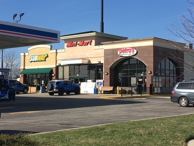
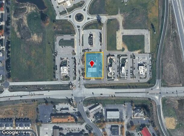
Property Record
2120 E King St, Franklin, IN 46131
NEARBY LISTINGS FOR SALE OR LEASE
Property Detail
2120 E King St
41-07-18-031-006.003-018
PT NE 1/4 SW 1/4 S18 T12 R5 (SHELL STATION) MP FRANKLIN COMMUNI
Conveniencestore
Johnson
X
Indiana
18081C0232D
1.08 AC
2024
Far South Johnson Cty
2025
Indianapolis
611100
Indianapolis-Carmel-Greenwood, IN
6,080 SF
DEMOGRAPHICS near 2120 E King St
1 mile
3 mile
5 mile
2024 Total Population
2,331
18,967
30,250
2029 Population
2,485
20,302
32,324
Pop Growth 2024-2029
+ 6.61%
+ 7.04%
+ 6.86%
Average Age
43
40
40
2024 Total Households
931
7,041
11,184
HH Growth 2024-2029
+ 6.66%
+ 7.23%
+ 7.00%
Median Household Inc
$83,899
$68,004
$70,947
Avg Household Size
2.40
2.50
2.50
2024 Avg HH Vehicles
2.00
2.00
2.00
Median Home Value
$274,716
$201,884
$197,388
Median Year Built
1990
1984
1991
Nearby Places
Map Layers
Map Styles
 Street
 Aerial
Transit
 Traffic
 Biking
Places
Listings with unknown addresses are not visible on the map
- Restaurants
- Banks
- Shops
- Fitness
- Groceries
PUBLIC TRANSPORTATION
AIRPORT
Indianapolis International
Drive
Walk
Distance
Indianapolis International
50 min
33.2 mi
SALE & LEASE HISTORY
LISTING DATE
SALE/LEASE

Nov 21, 2022
For Sale
Mar 15, 2022
For Lease
Nearby Properties
Address
Land Use
TOTAL SIZE
Lot Size
Zoning
Address
Land Use
TOTAL SIZE
Lot Size
Zoning
2,908 SF
216.91 AC
Address
Land Use
TOTAL SIZE
Lot Size
Zoning
954,880 SF
42.36 AC
Address
Land Use
TOTAL SIZE
Lot Size
Zoning
153,589 SF
160.27 AC
Address
Land Use
TOTAL SIZE
Lot Size
Zoning
933,504 SF
42.07 AC
Address
Land Use
TOTAL SIZE
Lot Size
Zoning
806,916 SF
42.56 AC
Address
Land Use
TOTAL SIZE
Lot Size
Zoning
519,376 SF
53.98 AC
Address
Land Use
TOTAL SIZE
Lot Size
Zoning
553,152 SF
35.86 AC
Address
Land Use
TOTAL SIZE
Lot Size
Zoning
160.96 AC
PUD
Address
Land Use
TOTAL SIZE
Lot Size
Zoning
18.95 AC
Address
Land Use
TOTAL SIZE
Lot Size
Zoning
8,504 SF
31.42 AC
Address
Land Use
TOTAL SIZE
Lot Size
Zoning
1,792 SF
66.50 AC
Address
Land Use
TOTAL SIZE
Lot Size
Zoning
146,505 SF
30.71 AC
Address
Land Use
TOTAL SIZE
Lot Size
Zoning
7,304 SF
15.32 AC
Address
Land Use
TOTAL SIZE
Lot Size
Zoning
119,499 SF
11.54 AC
Address
Land Use
TOTAL SIZE
Lot Size
Zoning
54,436 SF
18.83 AC
Address
Land Use
TOTAL SIZE
Lot Size
Zoning
207,310 SF
17.20 AC
Address
Land Use
TOTAL SIZE
Lot Size
Zoning
86,082 SF
8.14 AC
Address
Land Use
TOTAL SIZE
Lot Size
Zoning
193,690 SF
47 AC
Address
Land Use
TOTAL SIZE
Lot Size
Zoning
2,516 SF
7.87 AC
Address
Land Use
TOTAL SIZE
Lot Size
Zoning
66,906 SF
2.92 AC
Address
Land Use
TOTAL SIZE
Lot Size
Zoning
119,416 SF
11.51 AC
Address
Land Use
TOTAL SIZE
Lot Size
Zoning
26,208 SF
3.74 AC
PUD
Address
Land Use
TOTAL SIZE
Lot Size
Zoning
539,190 SF
33.27 AC
Address
Land Use
TOTAL SIZE
Lot Size
Zoning
39.94 AC
PUD
Address
Land Use
TOTAL SIZE
Lot Size
Zoning
140,328 SF
20 AC
Address
Land Use
TOTAL SIZE
Lot Size
Zoning
8,428 SF
7.39 AC
Address
Land Use
TOTAL SIZE
Lot Size
Zoning
133,820 SF
32.60 AC
Address
Land Use
TOTAL SIZE
Lot Size
Zoning
100,099 SF
9.37 AC
Address
Land Use
TOTAL SIZE
Lot Size
Zoning
49,807 SF
3.05 AC
Address
Land Use
TOTAL SIZE
Lot Size
Zoning
29,517 SF
10.45 AC
The World's #1 Commercial Real Estate Marketplace
Connect with us
© 2026 CoStar Group
The information above has been obtained from sources believed reliable. While we do not doubt its accuracy we have not verified it and make no guarantee, warranty or representation about it. It is your responsibility to independently confirm its accuracy and completeness. Any projections, opinions, assumptions, or estimates used are for example only and do not represent the current or future performance of the property. The value of this transaction to you depends on tax and other factors which should be evaluated by your tax, financial, and legal advisors. You and your advisors should conduct a careful, independent investigation of the property to determine to your satisfaction the suitability of the property for your needs.