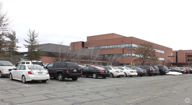
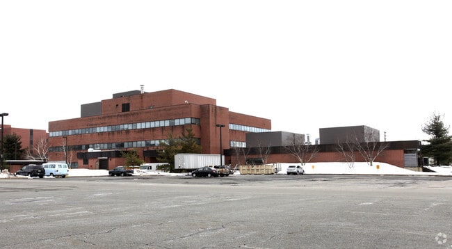
Property Record
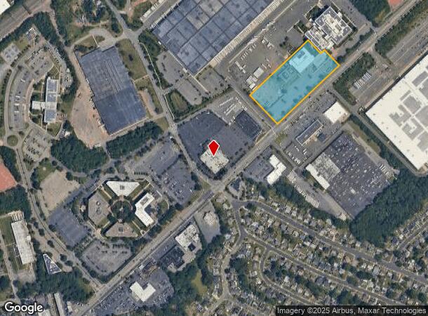
2121 State Route 27, Edison, NJ 08817

Current Lease Availabilities
NEARBY LISTINGS FOR SALE OR LEASE
Property Detail
2121 State Route 27
New York-Jersey City-White Plains, NY-NJ
Final Map Block 124 Lot 2-E-5 21 And 22
05-00124-0000-00021-01
5.47 AC
Officebuilding
Middlesex
X
New Jersey
34023C0042F
21.1
2024
5.47 AC
2025
Exit 10
001502
Northern New Jersey
DEMOGRAPHICS near 2121 State Route 27
1 Mile
3 Mile
5 Mile
2024 Total Population
9,525
104,738
300,557
2029 Population
9,472
103,948
299,081
Pop Growth 2024-2029
(0.56%)
(0.75%)
(0.49%)
Average Age
42
39
38
2024 Total Households
3,235
37,107
101,299
HH Growth 2024-2029
(0.62%)
(0.86%)
(0.44%)
Median Household Inc
$115,210
$112,158
$102,541
Avg Household Size
2.90
2.70
2.80
2024 Avg HH Vehicles
2.00
2.00
2.00
Median Home Value
$411,755
$432,457
$403,219
Median Year Built
1959
1969
1969
Nearby Places
Map Layers
Map Styles
 Street
 Aerial
- Restaurants
- Banks
- Shops
- Fitness
- Groceries
PUBLIC TRANSPORTATION
COMMUTER RAIL
Edison (Northeast Corridor Line - NJ Transit Commuter Rail (NJ Transit))
DRIVE
WALK
Distance
Edison (Northeast Corridor Line - NJ Transit Commuter Rail (NJ Transit))
5 min
1.8 mi
Metuchen (Northeast Corridor Line - NJ Transit Commuter Rail (NJ Transit))
DRIVE
WALK
Distance
Metuchen (Northeast Corridor Line - NJ Transit Commuter Rail (NJ Transit))
6 min
2.2 mi
AIRPORT
Newark Liberty International
DRIVE
WALK
Distance
Newark Liberty International
32 min
24.2 mi
Trenton Mercer
DRIVE
WALK
Distance
Trenton Mercer
48 min
32.3 mi
LaGuardia
DRIVE
WALK
Distance
LaGuardia
63 min
40.7 mi
Freight Ports
New York Container Terminal
DRIVE
WALK
Distance
New York Container Terminal
26 min
18.5 mi
Nearby Properties
Address
Land Use
TOTAL SIZE
Lot Size
Zoning
Address
Land Use
TOTAL SIZE
Lot Size
Zoning
37.46 AC
EI
Address
Land Use
TOTAL SIZE
Lot Size
Zoning
138,550 SF
104.63 AC
E
Address
Land Use
TOTAL SIZE
Lot Size
Zoning
52,074 SF
68.14 AC
E
Address
Land Use
TOTAL SIZE
Lot Size
Zoning
23,140 SF
107.63 AC
E
Address
Land Use
TOTAL SIZE
Lot Size
Zoning
165.43 AC
EI
Address
Land Use
TOTAL SIZE
Lot Size
Zoning
147.45 AC
RRRD
Address
Land Use
TOTAL SIZE
Lot Size
Zoning
137.89 AC
RAA
Address
Land Use
TOTAL SIZE
Lot Size
Zoning
49.83 AC
LI
Address
Land Use
TOTAL SIZE
Lot Size
Zoning
103,973 SF
51.10 AC
LI1
Address
Land Use
TOTAL SIZE
Lot Size
Zoning
55.57 AC
LI
Address
Land Use
TOTAL SIZE
Lot Size
Zoning
12,800 SF
17.08 AC
R-6
Address
Land Use
TOTAL SIZE
Lot Size
Zoning
40.78 AC
RRRD
Address
Land Use
TOTAL SIZE
Lot Size
Zoning
11.21 AC
.
Address
Land Use
TOTAL SIZE
Lot Size
Zoning
50.50 AC
LI
Address
Land Use
TOTAL SIZE
Lot Size
Zoning
9.81 AC
RMG
Address
Land Use
TOTAL SIZE
Lot Size
Zoning
12.43 AC
RMG
Address
Land Use
TOTAL SIZE
Lot Size
Zoning
118.40 AC
LI
Address
Land Use
TOTAL SIZE
Lot Size
Zoning
0.21 AC
LR
Address
Land Use
TOTAL SIZE
Lot Size
Zoning
35.98 AC
LI
Address
Land Use
TOTAL SIZE
Lot Size
Zoning
16,734 SF
9.37 AC
RM
Address
Land Use
TOTAL SIZE
Lot Size
Zoning
34.14 AC
LR
Address
Land Use
TOTAL SIZE
Lot Size
Zoning
3.18 AC
Address
Land Use
TOTAL SIZE
Lot Size
Zoning
162.66 AC
LI
Address
Land Use
TOTAL SIZE
Lot Size
Zoning
13.63 AC
RMG
Address
Land Use
TOTAL SIZE
Lot Size
Zoning
95,652 SF
38.24 AC
R20
Address
Land Use
TOTAL SIZE
Lot Size
Zoning
136.14 AC
E
Address
Land Use
TOTAL SIZE
Lot Size
Zoning
58.78 AC
LI
Address
Land Use
TOTAL SIZE
Lot Size
Zoning
53.95 AC
RRRD
Address
Land Use
TOTAL SIZE
Lot Size
Zoning
6.24 AC
RMG
Address
Land Use
TOTAL SIZE
Lot Size
Zoning
164.79 AC
LI
The World's #1 Commercial Real Estate Marketplace
Connect with us
© 2026 CoStar Group
The information above has been obtained from sources believed reliable. While we do not doubt its accuracy we have not verified it and make no guarantee, warranty or representation about it. It is your responsibility to independently confirm its accuracy and completeness. Any projections, opinions, assumptions, or estimates used are for example only and do not represent the current or future performance of the property. The value of this transaction to you depends on tax and other factors which should be evaluated by your tax, financial, and legal advisors. You and your advisors should conduct a careful, independent investigation of the property to determine to your satisfaction the suitability of the property for your needs.