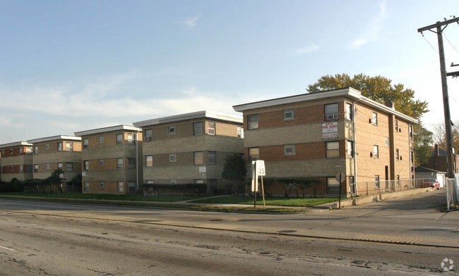
Property Record
2123 S 25Th Ave, Broadview, IL 60155
Save to a Folder
{{folder.Name}}
{{folder.ListingIds.length}} Properties
{{folder.ListingIds.length}} Property
Create a New Folder
Property Detail
2123 S 25Th Ave
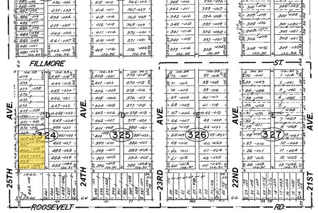
15-15-324-044-0000
Cook
Apartment
Illinois
B and X Area of moderate flood hazard, usually the area between the limits of the 100-year and 500-year floods.
465
2023
0.11 AC
2025
West Cook
818000
Chicago
5,308 SF
Chicago-Naperville-Elgin, IL-IN
NEARBY LISTINGS FOR SALE OR LEASE
DEMOGRAPHICS near 2123 S 25Th Ave
1 mile
3 mile
5 mile
2025 Total Population
18,725
147,651
464,347
2030 Population
18,791
148,024
465,213
Pop Growth 2025-2030
+ 0.35%
+ 0.25%
+ 0.19%
Average Age
43
41
41
2025 Total Households
6,849
53,615
169,939
HH Growth 2025-2030
+ 0.18%
+ 0.13%
+ 0.15%
Median Household Inc
$79,565
$82,346
$91,464
Avg Household Size
2.70
2.70
2.60
2025 Avg HH Vehicles
2.00
2.00
2.00
Median Home Value
$244,734
$282,307
$335,545
Median Year Built
1952
1954
1952
Nearby Places
Map Layers
Map Styles
 Street
 Aerial
Layers
 Traffic
 Biking
Places
Listings with unknown addresses are not visible on the map
- Restaurants
- Banks
- Shops
- Fitness
- Groceries
PUBLIC TRANSPORTATION
COMMUTER RAIL
Melrose Park Station (Union Pacific West Line - Northeast Illinois Regional Commuter Railroad (Metra))
Drive
Walk
Distance
Melrose Park Station (Union Pacific West Line - Northeast Illinois Regional Commuter Railroad (Metra))
5 min
2.2 mi
Maywood Station (Union Pacific West Line - Northeast Illinois Regional Commuter Railroad (Metra))
Drive
Walk
Distance
Maywood Station (Union Pacific West Line - Northeast Illinois Regional Commuter Railroad (Metra))
6 min
3.0 mi
AIRPORT
Chicago Midway International
Drive
Walk
Distance
Chicago Midway International
18 min
10.0 mi
Chicago O'Hare International
Drive
Walk
Distance
Chicago O'Hare International
20 min
11.3 mi
Freight Ports
Port Milwaukee
Drive
Walk
Distance
Port Milwaukee
104 min
83.7 mi
Nearby Properties
Address
Land Use
TOTAL SIZE
Lot Size
Zoning
Address
Land Use
TOTAL SIZE
Lot Size
Zoning
646,763 SF
17.54 AC
Address
Land Use
TOTAL SIZE
Lot Size
Zoning
Address
Land Use
TOTAL SIZE
Lot Size
Zoning
516,605 SF
16.29 AC
Address
Land Use
TOTAL SIZE
Lot Size
Zoning
8.53 AC
Address
Land Use
TOTAL SIZE
Lot Size
Zoning
1,156,393 SF
6.55 AC
Address
Land Use
TOTAL SIZE
Lot Size
Zoning
6.11 AC
Address
Land Use
TOTAL SIZE
Lot Size
Zoning
7.16 AC
Address
Land Use
TOTAL SIZE
Lot Size
Zoning
8.01 AC
Address
Land Use
TOTAL SIZE
Lot Size
Zoning
389,155 SF
17.69 AC
Address
Land Use
TOTAL SIZE
Lot Size
Zoning
Address
Land Use
TOTAL SIZE
Lot Size
Zoning
137,144 SF
11.77 AC
Address
Land Use
TOTAL SIZE
Lot Size
Zoning
184,970 SF
11.64 AC
Address
Land Use
TOTAL SIZE
Lot Size
Zoning
479,130 SF
15.80 AC
Address
Land Use
TOTAL SIZE
Lot Size
Zoning
108,276 SF
3.80 AC
Address
Land Use
TOTAL SIZE
Lot Size
Zoning
220,137 SF
13.24 AC
Address
Land Use
TOTAL SIZE
Lot Size
Zoning
225,000 SF
5.82 AC
Address
Land Use
TOTAL SIZE
Lot Size
Zoning
1.65 AC
Address
Land Use
TOTAL SIZE
Lot Size
Zoning
101,146 SF
2.24 AC
Address
Land Use
TOTAL SIZE
Lot Size
Zoning
320,928 SF
13.46 AC
Address
Land Use
TOTAL SIZE
Lot Size
Zoning
193,511 SF
17.89 AC
Address
Land Use
TOTAL SIZE
Lot Size
Zoning
53,800 SF
0.88 AC
Address
Land Use
TOTAL SIZE
Lot Size
Zoning
103,050 SF
7.49 AC
Address
Land Use
TOTAL SIZE
Lot Size
Zoning
42,720 SF
0.98 AC
Address
Land Use
TOTAL SIZE
Lot Size
Zoning
Address
Land Use
TOTAL SIZE
Lot Size
Zoning
242,662 SF
21.02 AC
Address
Land Use
TOTAL SIZE
Lot Size
Zoning
Address
Land Use
TOTAL SIZE
Lot Size
Zoning
274,375 SF
9.35 AC
Address
Land Use
TOTAL SIZE
Lot Size
Zoning
Address
Land Use
TOTAL SIZE
Lot Size
Zoning
170,722 SF
5.24 AC
Address
Land Use
TOTAL SIZE
Lot Size
Zoning
7.17 AC
The World's #1 Commercial Real Estate Marketplace
Connect with us
© 2026 CoStar Group
The information above has been obtained from sources believed reliable. While we do not doubt its accuracy we have not verified it and make no guarantee, warranty or representation about it. It is your responsibility to independently confirm its accuracy and completeness. Any projections, opinions, assumptions, or estimates used are for example only and do not represent the current or future performance of the property. The value of this transaction to you depends on tax and other factors which should be evaluated by your tax, financial, and legal advisors. You and your advisors should conduct a careful, independent investigation of the property to determine to your satisfaction the suitability of the property for your needs.