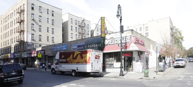
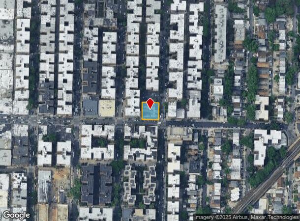
Property Record
2131 Barnes Ave, Bronx, NY 10462

NEARBY LISTINGS FOR SALE OR LEASE
Property Detail
2131 Barnes Ave
04321-0001
Bronx
Storebuilding
New York
X
1
3604970101F
0.23 AC
2024
Bronx
2025
Westchester/So Connecticut
023800
New York-Jersey City-White Plains, NY-NJ
9,790 SF
DEMOGRAPHICS near 2131 Barnes Ave
1 mile
3 mile
5 mile
2024 Total Population
85,155
1,014,457
1,765,929
2029 Population
77,252
935,027
1,637,062
Pop Growth 2024-2029
(9.28%)
(7.83%)
(7.30%)
Average Age
39
38
39
2024 Total Households
31,233
355,007
640,189
HH Growth 2024-2029
(9.94%)
(8.57%)
(7.86%)
Median Household Inc
$55,495
$43,486
$46,543
Avg Household Size
2.60
2.70
2.60
2024 Avg HH Vehicles
1.00
1.00
1.00
Median Home Value
$634,406
$504,399
$519,773
Median Year Built
1949
1951
1951
Nearby Places
Map Layers
Map Styles
 Street
 Aerial
Transit
 Traffic
 Biking
Places
Listings with unknown addresses are not visible on the map
- Restaurants
- Banks
- Shops
- Fitness
- Groceries
PUBLIC TRANSPORTATION
TRANSIT/SUBWAY
Morris Park (5 - New York MTA Subway (The Subway))
Drive
Walk
Distance
Morris Park (5 - New York MTA Subway (The Subway))
3 min
8 min
0.4 mi
Pelham Parkway (2,5 Line) (2 - New York MTA Subway (The Subway), 5 - New York MTA Subway (The Subway))
Drive
Walk
Distance
Pelham Parkway (2,5 Line) (2 - New York MTA Subway (The Subway), 5 - New York MTA Subway (The Subway))
3 min
8 min
0.4 mi
Bronx Park East (2 - New York MTA Subway (The Subway), 5 - New York MTA Subway (The Subway))
Drive
Walk
Distance
Bronx Park East (2 - New York MTA Subway (The Subway), 5 - New York MTA Subway (The Subway))
3 min
12 min
0.6 mi
Pelham Parkway (5 Line) (5 - New York MTA Subway (The Subway))
Drive
Walk
Distance
Pelham Parkway (5 Line) (5 - New York MTA Subway (The Subway))
5 min
13 min
0.7 mi
Allerton Avenue (2 - New York MTA Subway (The Subway), 5 - New York MTA Subway (The Subway))
Drive
Walk
Distance
Allerton Avenue (2 - New York MTA Subway (The Subway), 5 - New York MTA Subway (The Subway))
7 min
19 min
1.0 mi
COMMUTER RAIL
Fordham Station (Harlem Line - Metro-North Commuter Railroad Company (Metro-North), New Haven Line - Metro-North Commuter Railroad Company (Metro-North))
Drive
Walk
Distance
Fordham Station (Harlem Line - Metro-North Commuter Railroad Company (Metro-North), New Haven Line - Metro-North Commuter Railroad Company (Metro-North))
10 min
2.1 mi
Williams Bridge Station (Harlem Line - Metro-North Commuter Railroad Company (Metro-North))
Drive
Walk
Distance
Williams Bridge Station (Harlem Line - Metro-North Commuter Railroad Company (Metro-North))
8 min
2.2 mi
AIRPORT
LaGuardia
Drive
Walk
Distance
LaGuardia
19 min
10.9 mi
John F Kennedy International
Drive
Walk
Distance
John F Kennedy International
29 min
19.2 mi
Westchester County
Drive
Walk
Distance
Westchester County
32 min
22.6 mi
SALE & LEASE HISTORY
LISTING DATE
SALE/LEASE

Sep 25, 2016
For Lease
Nov 02, 2022
For Lease
Nearby Properties
Address
Land Use
TOTAL SIZE
Lot Size
Zoning
Address
Land Use
TOTAL SIZE
Lot Size
Zoning
115.90 AC
R6
Address
Land Use
TOTAL SIZE
Lot Size
Zoning
115.90 AC
R6
Address
Land Use
TOTAL SIZE
Lot Size
Zoning
115.90 AC
R6
Address
Land Use
TOTAL SIZE
Lot Size
Zoning
115.90 AC
R6
Address
Land Use
TOTAL SIZE
Lot Size
Zoning
115.90 AC
R6
Address
Land Use
TOTAL SIZE
Lot Size
Zoning
115.90 AC
R6
Address
Land Use
TOTAL SIZE
Lot Size
Zoning
115.90 AC
R6
Address
Land Use
TOTAL SIZE
Lot Size
Zoning
115.90 AC
R6
Address
Land Use
TOTAL SIZE
Lot Size
Zoning
115.90 AC
R6
Address
Land Use
TOTAL SIZE
Lot Size
Zoning
115.90 AC
R6
Address
Land Use
TOTAL SIZE
Lot Size
Zoning
115.90 AC
R6
Address
Land Use
TOTAL SIZE
Lot Size
Zoning
115.90 AC
R6
Address
Land Use
TOTAL SIZE
Lot Size
Zoning
115.90 AC
R6
Address
Land Use
TOTAL SIZE
Lot Size
Zoning
115.90 AC
R6
Address
Land Use
TOTAL SIZE
Lot Size
Zoning
115.90 AC
R6
Address
Land Use
TOTAL SIZE
Lot Size
Zoning
115.90 AC
R6
Address
Land Use
TOTAL SIZE
Lot Size
Zoning
115.90 AC
R6
Address
Land Use
TOTAL SIZE
Lot Size
Zoning
115.90 AC
R6
Address
Land Use
TOTAL SIZE
Lot Size
Zoning
115.90 AC
R6
Address
Land Use
TOTAL SIZE
Lot Size
Zoning
115.90 AC
R6
Address
Land Use
TOTAL SIZE
Lot Size
Zoning
115.90 AC
R6
Address
Land Use
TOTAL SIZE
Lot Size
Zoning
115.90 AC
R6
Address
Land Use
TOTAL SIZE
Lot Size
Zoning
115.90 AC
R6
Address
Land Use
TOTAL SIZE
Lot Size
Zoning
115.90 AC
R6
Address
Land Use
TOTAL SIZE
Lot Size
Zoning
115.90 AC
R6
Address
Land Use
TOTAL SIZE
Lot Size
Zoning
1,299,700 SF
29.82 AC
R6
Address
Land Use
TOTAL SIZE
Lot Size
Zoning
550,000 SF
8.75 AC
M1-1
Address
Land Use
TOTAL SIZE
Lot Size
Zoning
13,243,398 SF
115.90 AC
R6
Address
Land Use
TOTAL SIZE
Lot Size
Zoning
1,743,584 SF
77.87 AC
R6
Address
Land Use
TOTAL SIZE
Lot Size
Zoning
44.83 AC
R6
The World's #1 Commercial Real Estate Marketplace
Connect with us
© 2026 CoStar Group
The information above has been obtained from sources believed reliable. While we do not doubt its accuracy we have not verified it and make no guarantee, warranty or representation about it. It is your responsibility to independently confirm its accuracy and completeness. Any projections, opinions, assumptions, or estimates used are for example only and do not represent the current or future performance of the property. The value of this transaction to you depends on tax and other factors which should be evaluated by your tax, financial, and legal advisors. You and your advisors should conduct a careful, independent investigation of the property to determine to your satisfaction the suitability of the property for your needs.