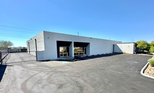
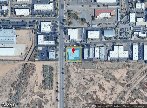
Property Record
21401 N 7Th Ave, Phoenix, AZ 85027

Current Lease Availabilities
NEARBY LISTINGS FOR SALE OR LEASE
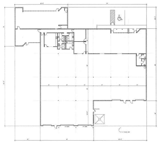
Property Detail
21401 N 7Th Ave
Phoenix-Mesa-Chandler, AZ
Deer Valley Industrial Center
209-10-019
DEER VALLEY INDUSTRIAL CENTER MCR 222-06
Autorepair
Maricopa
X
Arizona
04013C1290M
14
2025
0.89 AC
2025
Deer Vly/Pinnacle Pk
614700
Phoenix
14,920 SF
DEMOGRAPHICS near 21401 N 7Th Ave
1 Mile
3 Mile
5 Mile
2024 Total Population
4,028
91,575
250,694
2029 Population
4,318
99,025
271,309
Pop Growth 2024-2029
+ 7.20%
+ 8.14%
+ 8.22%
Average Age
38
38
38
2024 Total Households
1,670
38,358
100,006
HH Growth 2024-2029
+ 7.25%
+ 8.29%
+ 8.35%
Median Household Inc
$60,033
$68,043
$73,759
Avg Household Size
2.30
2.30
2.40
2024 Avg HH Vehicles
2.00
2.00
2.00
Median Home Value
$267,582
$299,118
$346,058
Median Year Built
1985
1988
1989
Nearby Places
Map Layers
Map Styles
 Street
 Aerial
- Restaurants
- Banks
- Shops
- Fitness
- Groceries
PUBLIC TRANSPORTATION
AIRPORT
Phoenix Sky Harbor International
DRIVE
WALK
Distance
Phoenix Sky Harbor International
35 min
25.2 mi
Phoenix-Mesa Gateway
DRIVE
WALK
Distance
Phoenix-Mesa Gateway
65 min
49.5 mi
Nearby Properties
Address
Land Use
TOTAL SIZE
Lot Size
Zoning
Address
Land Use
TOTAL SIZE
Lot Size
Zoning
159,642 SF
11.85 AC
C-C
Address
Land Use
TOTAL SIZE
Lot Size
Zoning
132,348 SF
9.16 AC
I-P
Address
Land Use
TOTAL SIZE
Lot Size
Zoning
Address
Land Use
TOTAL SIZE
Lot Size
Zoning
267,397 SF
108.70 AC
R-43AG
Address
Land Use
TOTAL SIZE
Lot Size
Zoning
704,521 SF
15.12 AC
C-C
Address
Land Use
TOTAL SIZE
Lot Size
Zoning
625,318 SF
15.79 AC
Address
Land Use
TOTAL SIZE
Lot Size
Zoning
16.84 AC
Address
Land Use
TOTAL SIZE
Lot Size
Zoning
434,799 SF
69.70 AC
R-8
Address
Land Use
TOTAL SIZE
Lot Size
Zoning
429,168 SF
9.52 AC
R-8
Address
Land Use
TOTAL SIZE
Lot Size
Zoning
289,901 SF
12.30 AC
A-1
Address
Land Use
TOTAL SIZE
Lot Size
Zoning
471,671 SF
18.04 AC
I-1
Address
Land Use
TOTAL SIZE
Lot Size
Zoning
17,365 SF
1.50 AC
C-G
Address
Land Use
TOTAL SIZE
Lot Size
Zoning
389,967 SF
245.48 AC
I-1
Address
Land Use
TOTAL SIZE
Lot Size
Zoning
264,909 SF
219.16 AC
I-1
Address
Land Use
TOTAL SIZE
Lot Size
Zoning
968,899 SF
76.37 AC
I-1
Address
Land Use
TOTAL SIZE
Lot Size
Zoning
361,228 SF
24.60 AC
I-P
Address
Land Use
TOTAL SIZE
Lot Size
Zoning
338,640 SF
10.39 AC
R-4A
Address
Land Use
TOTAL SIZE
Lot Size
Zoning
307,891 SF
15.89 AC
Address
Land Use
TOTAL SIZE
Lot Size
Zoning
336,529 SF
11.23 AC
R4A
Address
Land Use
TOTAL SIZE
Lot Size
Zoning
28.71 AC
Address
Land Use
TOTAL SIZE
Lot Size
Zoning
312,070 SF
20.04 AC
A1
Address
Land Use
TOTAL SIZE
Lot Size
Zoning
242,144 SF
29.78 AC
RE-43
Address
Land Use
TOTAL SIZE
Lot Size
Zoning
291,059 SF
16.54 AC
I-1
Address
Land Use
TOTAL SIZE
Lot Size
Zoning
240.86 AC
IND.PK.
Address
Land Use
TOTAL SIZE
Lot Size
Zoning
228,085 SF
7.84 AC
I-P
Address
Land Use
TOTAL SIZE
Lot Size
Zoning
355,606 SF
11.35 AC
C-C
Address
Land Use
TOTAL SIZE
Lot Size
Zoning
244,787 SF
5.83 AC
Address
Land Use
TOTAL SIZE
Lot Size
Zoning
255,482 SF
15.30 AC
M-H
Address
Land Use
TOTAL SIZE
Lot Size
Zoning
189,524 SF
13.80 AC
I-P
Address
Land Use
TOTAL SIZE
Lot Size
Zoning
483,381 SF
27.83 AC
C-C
The World's #1 Commercial Real Estate Marketplace
Connect with us
© 2026 CoStar Group
The information above has been obtained from sources believed reliable. While we do not doubt its accuracy we have not verified it and make no guarantee, warranty or representation about it. It is your responsibility to independently confirm its accuracy and completeness. Any projections, opinions, assumptions, or estimates used are for example only and do not represent the current or future performance of the property. The value of this transaction to you depends on tax and other factors which should be evaluated by your tax, financial, and legal advisors. You and your advisors should conduct a careful, independent investigation of the property to determine to your satisfaction the suitability of the property for your needs.