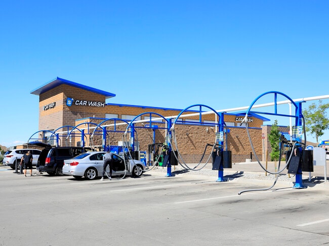
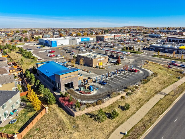
Property Record
21435 E Quincy Ave, Aurora, CO 80015


Property Detail
21435 E Quincy Ave
2073-02-4-20-001
SUBDIVISIONCD 054022 SUBDIVISIONNAME SADDLE ROCK HIGHLANDS SUB 2ND FLG BLOCK 001 LOT 001 LOT 1 BLK 1 SADDLE ROCK HIGHLANDS SUB 2ND FLG
Carwash
Arapahoe
AMU
Colorado
B and X Area of moderate flood hazard, usually the area between the limits of the 100-year and 500-year floods.
001
2024
0.85 AC
2025
Aurora
083201
Denver
4,121 SF
Denver-Aurora-Centennial, CO
NEARBY LISTINGS FOR SALE OR LEASE
-
-
View all Aurora listings for sale on LoopNet.com
DEMOGRAPHICS near 21435 E Quincy Ave
1 mile
3 mile
5 mile
2025 Total Population
17,979
110,720
243,067
2030 Population
18,394
111,643
246,241
Pop Growth 2025-2030
+ 2.31%
+ 0.83%
+ 1.31%
Average Age
35
38
39
2025 Total Households
5,349
36,126
84,504
HH Growth 2025-2030
+ 2.28%
+ 0.86%
+ 1.33%
Median Household Inc
$142,737
$123,789
$114,971
Avg Household Size
3.30
3.00
2.80
2025 Avg HH Vehicles
2.00
2.00
2.00
Median Home Value
$670,141
$613,947
$592,411
Median Year Built
2005
1994
1993
Nearby Places
Map Layers
Map Styles
 Street
 Aerial
Transit
 Traffic
 Biking
Places
Listings with unknown addresses are not visible on the map
- Restaurants
- Banks
- Shops
- Fitness
- Groceries
PUBLIC TRANSPORTATION
AIRPORT
Denver International
Drive
Walk
Distance
Denver International
25 min
21.5 mi
Freight Ports
Tulsa Port Of Catoosa
Drive
Walk
Distance
Tulsa Port Of Catoosa
718 min
701.4 mi
SALE & LEASE HISTORY
LISTING DATE
SALE/LEASE

Sep 07, 2023
For Sale
Oct 31, 2022
For Sale
Nov 18, 2025
For Sale
May 03, 2023
For Sale
Jun 08, 2023
For Sale
Dec 02, 2025
For Sale
Aug 22, 2022
For Sale
Apr 08, 2020
For Sale
Nearby Properties
Address
Land Use
TOTAL SIZE
Lot Size
Zoning
Address
Land Use
TOTAL SIZE
Lot Size
Zoning
328,000 SF
33.52 AC
PUD
Address
Land Use
TOTAL SIZE
Lot Size
Zoning
142,378 SF
14.64 AC
Address
Land Use
TOTAL SIZE
Lot Size
Zoning
168,500 SF
24.03 AC
Address
Land Use
TOTAL SIZE
Lot Size
Zoning
368,462 SF
11.68 AC
RZMF
Address
Land Use
TOTAL SIZE
Lot Size
Zoning
137,372 SF
5.86 AC
Address
Land Use
TOTAL SIZE
Lot Size
Zoning
129,701 SF
6.56 AC
Address
Land Use
TOTAL SIZE
Lot Size
Zoning
1,635 SF
26.38 AC
AMU
Address
Land Use
TOTAL SIZE
Lot Size
Zoning
376,563 SF
12.17 AC
AMU
Address
Land Use
TOTAL SIZE
Lot Size
Zoning
489,120 SF
20.10 AC
RE470
Address
Land Use
TOTAL SIZE
Lot Size
Zoning
176,000 SF
10.83 AC
PUD
Address
Land Use
TOTAL SIZE
Lot Size
Zoning
151,246 SF
13.25 AC
RE470
Address
Land Use
TOTAL SIZE
Lot Size
Zoning
105,244 SF
12.64 AC
RPCZD
Address
Land Use
TOTAL SIZE
Lot Size
Zoning
473.14 AC
AA1
Address
Land Use
TOTAL SIZE
Lot Size
Zoning
379,109 SF
16.45 AC
Address
Land Use
TOTAL SIZE
Lot Size
Zoning
206,064 SF
25.38 AC
AMU
Address
Land Use
TOTAL SIZE
Lot Size
Zoning
206,122 SF
24.97 AC
Address
Land Use
TOTAL SIZE
Lot Size
Zoning
114,838 SF
12.50 AC
Address
Land Use
TOTAL SIZE
Lot Size
Zoning
91,380 SF
5.52 AC
Address
Land Use
TOTAL SIZE
Lot Size
Zoning
84,662 SF
8.14 AC
PUD
Address
Land Use
TOTAL SIZE
Lot Size
Zoning
255,676 SF
13.97 AC
PUD
Address
Land Use
TOTAL SIZE
Lot Size
Zoning
140,000 SF
24.16 AC
AMU
Address
Land Use
TOTAL SIZE
Lot Size
Zoning
70,715 SF
13.57 AC
Address
Land Use
TOTAL SIZE
Lot Size
Zoning
44.65 AC
Address
Land Use
TOTAL SIZE
Lot Size
Zoning
36.34 AC
Address
Land Use
TOTAL SIZE
Lot Size
Zoning
55,800 SF
12.80 AC
Address
Land Use
TOTAL SIZE
Lot Size
Zoning
29,361 SF
4.60 AC
RB1
Address
Land Use
TOTAL SIZE
Lot Size
Zoning
19.54 AC
RZSFD
Address
Land Use
TOTAL SIZE
Lot Size
Zoning
19.39 AC
PUD
Address
Land Use
TOTAL SIZE
Lot Size
Zoning
14,066 SF
13.98 AC
AMU
Address
Land Use
TOTAL SIZE
Lot Size
Zoning
15.04 AC
The World's #1 Commercial Real Estate Marketplace
Connect with us
© 2026 CoStar Group
The information above has been obtained from sources believed reliable. While we do not doubt its accuracy we have not verified it and make no guarantee, warranty or representation about it. It is your responsibility to independently confirm its accuracy and completeness. Any projections, opinions, assumptions, or estimates used are for example only and do not represent the current or future performance of the property. The value of this transaction to you depends on tax and other factors which should be evaluated by your tax, financial, and legal advisors. You and your advisors should conduct a careful, independent investigation of the property to determine to your satisfaction the suitability of the property for your needs.