Property Record
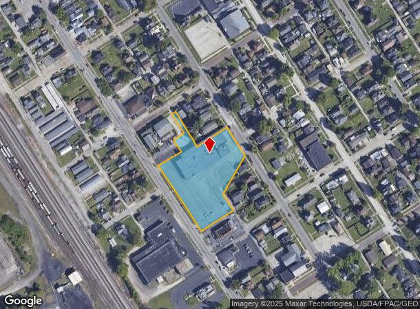
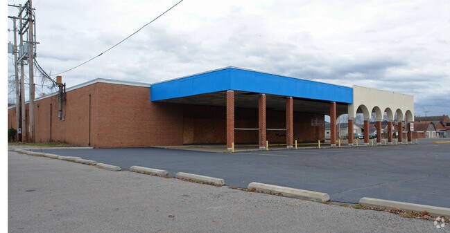
2147 S 3Rd St, Ironton, OH 45638

NEARBY LISTINGS FOR SALE OR LEASE
Property Detail
2147 S 3Rd St
Huntington-Ashland, WV-KY-OH
Ironton
36-021-1200-000
-00-00 17PT S D 1&2WH S D PT L47 AD PL 1870 L1&2 KEYS AD 0001.69A
Vehiclerentalsvehiclesales
Lawrence
X
Ohio
21089C0218D
47
0
1.69 AC
2024
Lawrence County
050800
Huntington/Ashland
25,386 SF
DEMOGRAPHICS near 2147 S 3Rd St
1 Mile
3 Mile
5 Mile
2024 Total Population
5,683
27,894
56,510
2029 Population
5,490
27,216
55,420
Pop Growth 2024-2029
(3.40%)
(2.43%)
(1.93%)
Average Age
43
42
42
2024 Total Households
2,406
11,610
23,513
HH Growth 2024-2029
(3.24%)
(2.33%)
(1.85%)
Median Household Inc
$43,339
$52,334
$51,165
Avg Household Size
2.20
2.30
2.30
2024 Avg HH Vehicles
2.00
2.00
2.00
Median Home Value
$83,238
$117,507
$113,190
Median Year Built
1948
1964
1965
Nearby Places
Map Layers
Map Styles
 Street
 Aerial
- Restaurants
- Banks
- Shops
- Fitness
- Groceries
PUBLIC TRANSPORTATION
COMMUTER RAIL
DRIVE
WALK
Distance
8 min
4.0 mi
AIRPORT
Tri-State/Milton J Ferguson Field
DRIVE
WALK
Distance
Tri-State/Milton J Ferguson Field
27 min
15.7 mi
SALE & LEASE HISTORY
LISTING DATE
SALE/LEASE

Sep 25, 2016
For Lease
Nearby Properties
Address
Land Use
TOTAL SIZE
Lot Size
Zoning
Address
Land Use
TOTAL SIZE
Lot Size
Zoning
Address
Land Use
TOTAL SIZE
Lot Size
Zoning
29.92 AC
Z02
Address
Land Use
TOTAL SIZE
Lot Size
Zoning
3,514 SF
21.96 AC
Z02
Address
Land Use
TOTAL SIZE
Lot Size
Zoning
1.94 AC
Z03
Address
Land Use
TOTAL SIZE
Lot Size
Zoning
Address
Land Use
TOTAL SIZE
Lot Size
Zoning
11.95 AC
Address
Land Use
TOTAL SIZE
Lot Size
Zoning
12.54 AC
Address
Land Use
TOTAL SIZE
Lot Size
Zoning
4.47 AC
COMMERCIAL
Address
Land Use
TOTAL SIZE
Lot Size
Zoning
28.87 AC
COMMERCIAL
Address
Land Use
TOTAL SIZE
Lot Size
Zoning
0.38 AC
COMMERCIAL
Address
Land Use
TOTAL SIZE
Lot Size
Zoning
40.94 AC
Address
Land Use
TOTAL SIZE
Lot Size
Zoning
Address
Land Use
TOTAL SIZE
Lot Size
Zoning
1.67 AC
RESIDENTIA
Address
Land Use
TOTAL SIZE
Lot Size
Zoning
1.63 AC
COMMERCIAL
Address
Land Use
TOTAL SIZE
Lot Size
Zoning
Address
Land Use
TOTAL SIZE
Lot Size
Zoning
3.86 AC
Address
Land Use
TOTAL SIZE
Lot Size
Zoning
19.91 AC
Address
Land Use
TOTAL SIZE
Lot Size
Zoning
1,424 SF
6.46 AC
Address
Land Use
TOTAL SIZE
Lot Size
Zoning
139,148 SF
Address
Land Use
TOTAL SIZE
Lot Size
Zoning
1.95 AC
COMMERCIAL
Address
Land Use
TOTAL SIZE
Lot Size
Zoning
35,014 SF
3.81 AC
Address
Land Use
TOTAL SIZE
Lot Size
Zoning
9.43 AC
Address
Land Use
TOTAL SIZE
Lot Size
Zoning
4.30 AC
COMMERCIAL
Address
Land Use
TOTAL SIZE
Lot Size
Zoning
30,250 SF
8.29 AC
Address
Land Use
TOTAL SIZE
Lot Size
Zoning
75,820 SF
1.71 AC
Address
Land Use
TOTAL SIZE
Lot Size
Zoning
1,440 SF
1.38 AC
Address
Land Use
TOTAL SIZE
Lot Size
Zoning
9.49 AC
Address
Land Use
TOTAL SIZE
Lot Size
Zoning
Address
Land Use
TOTAL SIZE
Lot Size
Zoning
0.21 AC
Z02
Address
Land Use
TOTAL SIZE
Lot Size
Zoning
47,557 SF
1.69 AC
The World's #1 Commercial Real Estate Marketplace
Connect with us
© 2025 CoStar Group
The information above has been obtained from sources believed reliable. While we do not doubt its accuracy we have not verified it and make no guarantee, warranty or representation about it. It is your responsibility to independently confirm its accuracy and completeness. Any projections, opinions, assumptions, or estimates used are for example only and do not represent the current or future performance of the property. The value of this transaction to you depends on tax and other factors which should be evaluated by your tax, financial, and legal advisors. You and your advisors should conduct a careful, independent investigation of the property to determine to your satisfaction the suitability of the property for your needs.