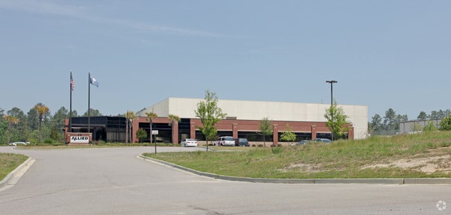
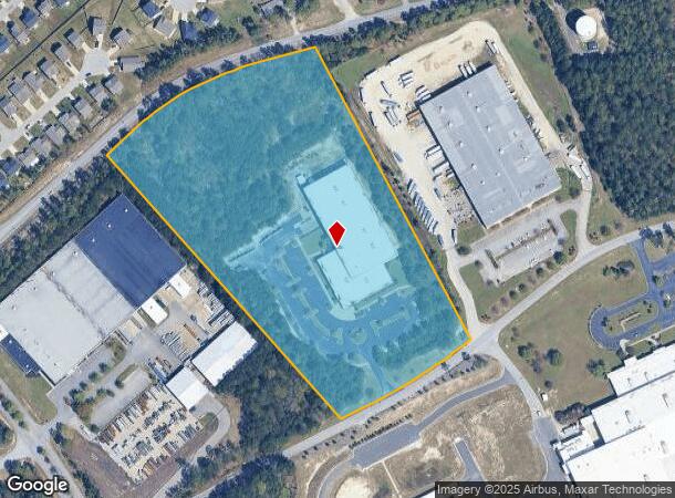
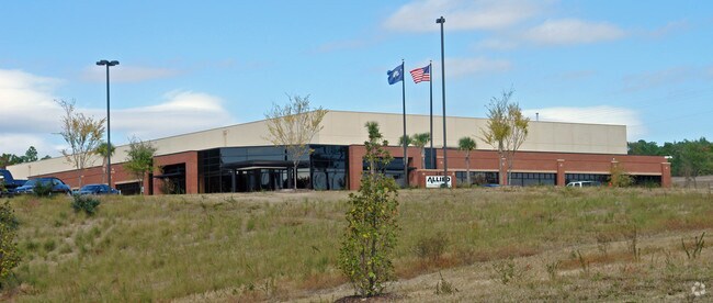
Property Record
215 Metropolitan Dr, West Columbia, SC 29170
NEARBY LISTINGS FOR SALE OR LEASE
Property Detail
215 Metropolitan Dr
005698-03-029
PARCEL A
Governmentalpublicusegeneral
Lexington
X
South Carolina
45063C0259J
13 AC
2025
Cayce/West Columbia
2024
Columbia
980100
Columbia, SC
70,740 SF
DEMOGRAPHICS near 215 Metropolitan Dr
1 Mile
3 Mile
5 Mile
2024 Total Population
2,572
30,822
87,961
2029 Population
2,817
33,489
95,754
Pop Growth 2024-2029
+ 9.53%
+ 8.65%
+ 8.86%
Average Age
39
40
40
2024 Total Households
1,050
12,622
36,858
HH Growth 2024-2029
+ 9.71%
+ 8.83%
+ 9.06%
Median Household Inc
$63,287
$64,827
$62,355
Avg Household Size
2.40
2.40
2.30
2024 Avg HH Vehicles
2.00
2.00
2.00
Median Home Value
$147,603
$158,023
$163,949
Median Year Built
1982
1986
1987
Nearby Places
Map Layers
Map Styles
 Street
 Aerial
- Restaurants
- Banks
- Shops
- Fitness
- Groceries
PUBLIC TRANSPORTATION
COMMUTER RAIL
Columbia Amtrak Station (Silver Star - Amtrak)
DRIVE
WALK
Distance
Columbia Amtrak Station (Silver Star - Amtrak)
15 min
8.5 mi
AIRPORT
Columbia Metro
DRIVE
WALK
Distance
Columbia Metro
17 min
4.8 mi
Freight Ports
North Charleston Terminal
DRIVE
WALK
Distance
North Charleston Terminal
121 min
104.7 mi
SALE & LEASE HISTORY
LISTING DATE
SALE/LEASE

Jan 18, 2017
For Sale
Nearby Properties
Address
Land Use
TOTAL SIZE
Lot Size
Zoning
Address
Land Use
TOTAL SIZE
Lot Size
Zoning
461,888 SF
61.50 AC
ID
Address
Land Use
TOTAL SIZE
Lot Size
Zoning
3,614 SF
1,444.32 AC
ID
Address
Land Use
TOTAL SIZE
Lot Size
Zoning
222,557 SF
26.90 AC
ID
Address
Land Use
TOTAL SIZE
Lot Size
Zoning
10,304 SF
11.89 AC
R1
Address
Land Use
TOTAL SIZE
Lot Size
Zoning
58.81 AC
RD
Address
Land Use
TOTAL SIZE
Lot Size
Zoning
257,688 SF
23.03 AC
ID
Address
Land Use
TOTAL SIZE
Lot Size
Zoning
41,860 SF
6.54 AC
ID
Address
Land Use
TOTAL SIZE
Lot Size
Zoning
318,309 SF
33.51 AC
ID
Address
Land Use
TOTAL SIZE
Lot Size
Zoning
7,383 SF
4.85 AC
ID
Address
Land Use
TOTAL SIZE
Lot Size
Zoning
59.61 AC
ID
Address
Land Use
TOTAL SIZE
Lot Size
Zoning
430.11 AC
ID
Address
Land Use
TOTAL SIZE
Lot Size
Zoning
254,399 SF
49.79 AC
ID
Address
Land Use
TOTAL SIZE
Lot Size
Zoning
54,000 SF
8.60 AC
ID
Address
Land Use
TOTAL SIZE
Lot Size
Zoning
147,166 SF
18.27 AC
ID
Address
Land Use
TOTAL SIZE
Lot Size
Zoning
8,269 SF
12.99 AC
RD
Address
Land Use
TOTAL SIZE
Lot Size
Zoning
10.52 AC
ID
Address
Land Use
TOTAL SIZE
Lot Size
Zoning
115,000 SF
11.99 AC
ID
Address
Land Use
TOTAL SIZE
Lot Size
Zoning
73,778 SF
4.95 AC
A
Address
Land Use
TOTAL SIZE
Lot Size
Zoning
17,442 SF
2.78 AC
Address
Land Use
TOTAL SIZE
Lot Size
Zoning
54,092 SF
5.90 AC
ID
Address
Land Use
TOTAL SIZE
Lot Size
Zoning
95,730 SF
8.15 AC
ID
Address
Land Use
TOTAL SIZE
Lot Size
Zoning
3,250 SF
0.94 AC
ID
Address
Land Use
TOTAL SIZE
Lot Size
Zoning
52,096 SF
10.35 AC
ID
Address
Land Use
TOTAL SIZE
Lot Size
Zoning
29,167 SF
3.15 AC
ID
Address
Land Use
TOTAL SIZE
Lot Size
Zoning
480 SF
17.33 AC
RD
Address
Land Use
TOTAL SIZE
Lot Size
Zoning
54,883 SF
5.63 AC
ID
Address
Land Use
TOTAL SIZE
Lot Size
Zoning
69,870 SF
13.56 AC
ID
Address
Land Use
TOTAL SIZE
Lot Size
Zoning
35,712 SF
1.74 AC
RS1
Address
Land Use
TOTAL SIZE
Lot Size
Zoning
67,312 SF
2.04 AC
ID
The World's #1 Commercial Real Estate Marketplace
Connect with us
© 2025 CoStar Group
The information above has been obtained from sources believed reliable. While we do not doubt its accuracy we have not verified it and make no guarantee, warranty or representation about it. It is your responsibility to independently confirm its accuracy and completeness. Any projections, opinions, assumptions, or estimates used are for example only and do not represent the current or future performance of the property. The value of this transaction to you depends on tax and other factors which should be evaluated by your tax, financial, and legal advisors. You and your advisors should conduct a careful, independent investigation of the property to determine to your satisfaction the suitability of the property for your needs.