Property Record
2153 S Wabash St, Denver, CO 80231
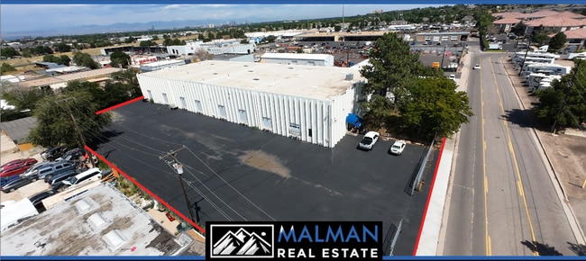


This Property Is For Sale
Current Lease Availabilities
Property Detail
2153 S Wabash St
Denver-Aurora-Centennial, CO
SUBDIVISIONCD 029650 SUBDIVISIONNAME HART BROWN SUB BLOCK 001 LOT 000 POR LOT 1 BEG 164.8 FT N OF SE COR SD LOT TH N 174.8 FT TH W 302.89 FT TH S 174.74 FT TH E 302.83 FT TO BEG EX MRS HART BROWN SUB
1973-28-1-02-010
Arapahoe
Warehouse
Colorado
B and X Area of moderate flood hazard, usually the area between the limits of the 100-year and 500-year floods.
000,1
2025
1.22 AC
2025
Glendale
087200
Denver
25,356 SF
NEARBY LISTINGS FOR SALE OR LEASE
DEMOGRAPHICS near 2153 S Wabash St
1 mile
3 mile
5 mile
2025 Total Population
28,939
193,413
451,130
2030 Population
29,932
197,763
460,955
Pop Growth 2025-2030
+ 3.43%
+ 2.25%
+ 2.18%
Average Age
38
40
39
2025 Total Households
13,283
89,108
197,153
HH Growth 2025-2030
+ 3.50%
+ 2.32%
+ 2.33%
Median Household Inc
$78,875
$75,497
$84,774
Avg Household Size
2.10
2.10
2.20
2025 Avg HH Vehicles
2.00
2.00
2.00
Median Home Value
$532,245
$540,259
$618,969
Median Year Built
1986
1978
1978
Nearby Places
Map Layers
Map Styles
 Street
 Aerial
Layers
 Traffic
 Biking
Places
Listings with unknown addresses are not visible on the map
- Restaurants
- Banks
- Shops
- Fitness
- Groceries
PUBLIC TRANSPORTATION
COMMUTER RAIL
Drive
Walk
Distance
18 min
8.3 mi
Drive
Walk
Distance
18 min
8.3 mi
AIRPORT
Denver International
Drive
Walk
Distance
Denver International
32 min
23.8 mi
Nearby Properties
Address
Land Use
TOTAL SIZE
Lot Size
Zoning
Address
Land Use
TOTAL SIZE
Lot Size
Zoning
551,531 SF
5.09 AC
C-MX
Address
Land Use
TOTAL SIZE
Lot Size
Zoning
508,135 SF
6.99 AC
C-RX
Address
Land Use
TOTAL SIZE
Lot Size
Zoning
163,033 SF
5.94 AC
PUD
Address
Land Use
TOTAL SIZE
Lot Size
Zoning
87,207 SF
Address
Land Use
TOTAL SIZE
Lot Size
Zoning
240,545 SF
2.35 AC
C-MX-20
Address
Land Use
TOTAL SIZE
Lot Size
Zoning
476,186 SF
42.62 AC
Address
Land Use
TOTAL SIZE
Lot Size
Zoning
416,096 SF
5.20 AC
C-MX-20
Address
Land Use
TOTAL SIZE
Lot Size
Zoning
70,296 SF
4.96 AC
Address
Land Use
TOTAL SIZE
Lot Size
Zoning
74,888 SF
4.35 AC
AMU
Address
Land Use
TOTAL SIZE
Lot Size
Zoning
320,589 SF
33.33 AC
S-SU-F
Address
Land Use
TOTAL SIZE
Lot Size
Zoning
14,878 SF
34.55 AC
OS-B
Address
Land Use
TOTAL SIZE
Lot Size
Zoning
83,951 SF
0.30 AC
R2
Address
Land Use
TOTAL SIZE
Lot Size
Zoning
50,106 SF
1.67 AC
RB1
Address
Land Use
TOTAL SIZE
Lot Size
Zoning
231,867 SF
19.33 AC
S-MX-3A
Address
Land Use
TOTAL SIZE
Lot Size
Zoning
613,600 SF
29.40 AC
R-3
Address
Land Use
TOTAL SIZE
Lot Size
Zoning
40,268 SF
8.35 AC
S-SU-F
Address
Land Use
TOTAL SIZE
Lot Size
Zoning
169,350 SF
19.74 AC
H-1-B
Address
Land Use
TOTAL SIZE
Lot Size
Zoning
48,630 SF
3.31 AC
C-MX-8
Address
Land Use
TOTAL SIZE
Lot Size
Zoning
34,413 SF
2.52 AC
S-MX-5
Address
Land Use
TOTAL SIZE
Lot Size
Zoning
112,322 SF
10.26 AC
S-CC-3
Address
Land Use
TOTAL SIZE
Lot Size
Zoning
18,872 SF
11.34 AC
E-SU
Address
Land Use
TOTAL SIZE
Lot Size
Zoning
148,088 SF
10.61 AC
B-3
Address
Land Use
TOTAL SIZE
Lot Size
Zoning
380,376 SF
24.52 AC
E-SU-DX
Address
Land Use
TOTAL SIZE
Lot Size
Zoning
205,129 SF
2.94 AC
C-MX-20
Address
Land Use
TOTAL SIZE
Lot Size
Zoning
61,018 SF
2.72 AC
C-MX
Address
Land Use
TOTAL SIZE
Lot Size
Zoning
130,531 SF
3.41 AC
Address
Land Use
TOTAL SIZE
Lot Size
Zoning
107,627 SF
1.59 AC
C-MX-5
Address
Land Use
TOTAL SIZE
Lot Size
Zoning
478,994 SF
26.07 AC
Address
Land Use
TOTAL SIZE
Lot Size
Zoning
273,652 SF
13.48 AC
S-CC-5X
Address
Land Use
TOTAL SIZE
Lot Size
Zoning
48,961 SF
4.15 AC
The World's #1 Commercial Real Estate Marketplace
Connect with us
© 2026 CoStar Group
The information above has been obtained from sources believed reliable. While we do not doubt its accuracy we have not verified it and make no guarantee, warranty or representation about it. It is your responsibility to independently confirm its accuracy and completeness. Any projections, opinions, assumptions, or estimates used are for example only and do not represent the current or future performance of the property. The value of this transaction to you depends on tax and other factors which should be evaluated by your tax, financial, and legal advisors. You and your advisors should conduct a careful, independent investigation of the property to determine to your satisfaction the suitability of the property for your needs.