Property Record
217 W Hopkins St, San Marcos, TX 78666
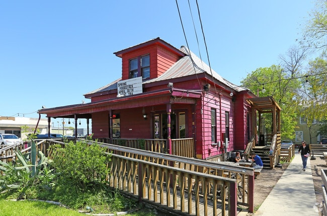


Property Detail
217 W Hopkins St
Austin-Round Rock-San Marcos, TX
ORIGINAL TOWN OF SAN MARCOS, BLOCK 15, LOT 6, ACRES 0.2272
R41576
Hays
Commercialnec
Texas
B and X Area of moderate flood hazard, usually the area between the limits of the 100-year and 500-year floods.
6
2024
0.23 AC
2025
Hays County
010100
Austin
1,604 SF
NEARBY LISTINGS FOR SALE OR LEASE
DEMOGRAPHICS near 217 W Hopkins St
1 mile
3 mile
5 mile
2025 Total Population
14,076
62,229
84,376
2030 Population
15,937
70,981
96,792
Pop Growth 2025-2030
+ 13.22%
+ 14.06%
+ 14.72%
Average Age
29
32
33
2025 Total Households
4,527
25,841
33,675
HH Growth 2025-2030
+ 15.60%
+ 15.33%
+ 16.01%
Median Household Inc
$45,404
$48,805
$54,505
Avg Household Size
2.10
2.20
2.30
2025 Avg HH Vehicles
2.00
2.00
2.00
Median Home Value
$320,979
$311,772
$313,911
Median Year Built
1985
1996
1999
Nearby Places
Map Layers
Map Styles
 Street
 Aerial
Transit
 Traffic
 Biking
Places
Listings with unknown addresses are not visible on the map
- Restaurants
- Banks
- Shops
- Fitness
- Groceries
PUBLIC TRANSPORTATION
COMMUTER RAIL
Drive
Walk
Distance
2 min
11 min
0.6 mi
AIRPORT
Austin-Bergstrom International
Drive
Walk
Distance
Austin-Bergstrom International
48 min
36.1 mi
San Antonio International
Drive
Walk
Distance
San Antonio International
51 min
43.9 mi
SALE & LEASE HISTORY
LISTING DATE
SALE/LEASE

Jan 20, 2025
For Sale
Nearby Properties
Address
Land Use
TOTAL SIZE
Lot Size
Zoning
Address
Land Use
TOTAL SIZE
Lot Size
Zoning
623,823 SF
1.46 AC
Address
Land Use
TOTAL SIZE
Lot Size
Zoning
215,932 SF
3.67 AC
Address
Land Use
TOTAL SIZE
Lot Size
Zoning
419,973 SF
23.69 AC
Address
Land Use
TOTAL SIZE
Lot Size
Zoning
324,430 SF
23.60 AC
Address
Land Use
TOTAL SIZE
Lot Size
Zoning
479,270 SF
24.78 AC
Address
Land Use
TOTAL SIZE
Lot Size
Zoning
458,948 SF
35.43 AC
Address
Land Use
TOTAL SIZE
Lot Size
Zoning
343,094 SF
39.30 AC
Address
Land Use
TOTAL SIZE
Lot Size
Zoning
545,643 SF
2.69 AC
Address
Land Use
TOTAL SIZE
Lot Size
Zoning
279,131 SF
22.46 AC
Address
Land Use
TOTAL SIZE
Lot Size
Zoning
466,968 SF
15.19 AC
Address
Land Use
TOTAL SIZE
Lot Size
Zoning
311,146 SF
5.11 AC
Address
Land Use
TOTAL SIZE
Lot Size
Zoning
264,570 SF
14.23 AC
Address
Land Use
TOTAL SIZE
Lot Size
Zoning
352,285 SF
12.75 AC
Address
Land Use
TOTAL SIZE
Lot Size
Zoning
283,033 SF
19.46 AC
Address
Land Use
TOTAL SIZE
Lot Size
Zoning
327,917 SF
10.54 AC
Address
Land Use
TOTAL SIZE
Lot Size
Zoning
266,157 SF
14.70 AC
Address
Land Use
TOTAL SIZE
Lot Size
Zoning
278,193 SF
17.44 AC
Address
Land Use
TOTAL SIZE
Lot Size
Zoning
365,750 SF
19.65 AC
Address
Land Use
TOTAL SIZE
Lot Size
Zoning
184,438 SF
12.57 AC
Address
Land Use
TOTAL SIZE
Lot Size
Zoning
277,659 SF
10.77 AC
Address
Land Use
TOTAL SIZE
Lot Size
Zoning
306,818 SF
18.33 AC
Address
Land Use
TOTAL SIZE
Lot Size
Zoning
307,962 SF
14.23 AC
Address
Land Use
TOTAL SIZE
Lot Size
Zoning
215,688 SF
10.36 AC
Address
Land Use
TOTAL SIZE
Lot Size
Zoning
24.14 AC
Address
Land Use
TOTAL SIZE
Lot Size
Zoning
179,764 SF
3.27 AC
Address
Land Use
TOTAL SIZE
Lot Size
Zoning
193,192 SF
18.45 AC
Address
Land Use
TOTAL SIZE
Lot Size
Zoning
248,868 SF
17.77 AC
Address
Land Use
TOTAL SIZE
Lot Size
Zoning
145,336 SF
0.87 AC
Address
Land Use
TOTAL SIZE
Lot Size
Zoning
195,018 SF
7.37 AC
Address
Land Use
TOTAL SIZE
Lot Size
Zoning
185,184 SF
11.22 AC
The World's #1 Commercial Real Estate Marketplace
Connect with us
© 2026 CoStar Group
The information above has been obtained from sources believed reliable. While we do not doubt its accuracy we have not verified it and make no guarantee, warranty or representation about it. It is your responsibility to independently confirm its accuracy and completeness. Any projections, opinions, assumptions, or estimates used are for example only and do not represent the current or future performance of the property. The value of this transaction to you depends on tax and other factors which should be evaluated by your tax, financial, and legal advisors. You and your advisors should conduct a careful, independent investigation of the property to determine to your satisfaction the suitability of the property for your needs.