Property Record
217 W Main St, Groton, MA 01450

NEARBY LISTINGS FOR SALE OR LEASE
Property Detail
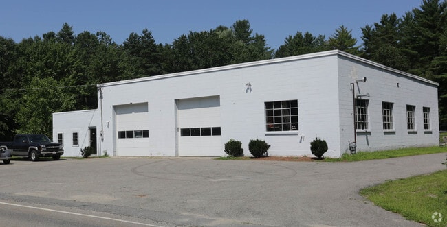
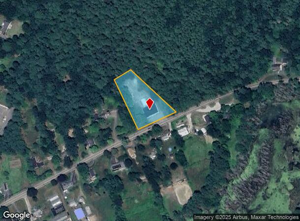
217 W Main St
Governmentalpublicusegeneral
Middlesex
X
Massachusetts
25017C0279G
1.30 AC
0
Groton/Townsend
2025
Boston
326102
Boston-Cambridge-Newton, MA-NH
4,800 SF
GROT-000106-000045
DEMOGRAPHICS near 217 W Main St
1 Mile
3 Mile
5 Mile
2024 Total Population
1,308
9,252
38,108
2029 Population
1,298
9,127
37,806
Pop Growth 2024-2029
(0.76%)
(1.35%)
(0.79%)
Average Age
42
43
43
2024 Total Households
455
3,383
13,898
HH Growth 2024-2029
(0.88%)
(1.45%)
(0.86%)
Median Household Inc
$149,999
$142,408
$118,416
Avg Household Size
2.80
2.60
2.50
2024 Avg HH Vehicles
2.00
2.00
2.00
Median Home Value
$555,814
$487,027
$431,303
Median Year Built
1995
1986
1978
Nearby Places
Map Layers
Map Styles
 Street
 Aerial
- Restaurants
- Banks
- Shops
- Fitness
- Groceries
PUBLIC TRANSPORTATION
COMMUTER RAIL
Ayer (Fitchburg/South Acton Line - Massachusetts Bay Transportation Authority Commuter Rail (Purple Line))
DRIVE
WALK
Distance
Ayer (Fitchburg/South Acton Line - Massachusetts Bay Transportation Authority Commuter Rail (Purple Line))
10 min
5.6 mi
Shirley (Fitchburg/South Acton Line - Massachusetts Bay Transportation Authority Commuter Rail (Purple Line))
DRIVE
WALK
Distance
Shirley (Fitchburg/South Acton Line - Massachusetts Bay Transportation Authority Commuter Rail (Purple Line))
15 min
7.2 mi
AIRPORT
Manchester Boston Regional
DRIVE
WALK
Distance
Manchester Boston Regional
53 min
30.3 mi
Worcester Regional
DRIVE
WALK
Distance
Worcester Regional
60 min
36.7 mi
Freight Ports
Port of Boston
DRIVE
WALK
Distance
Port of Boston
68 min
42.8 mi
Nearby Properties
Address
Land Use
TOTAL SIZE
Lot Size
Zoning
Address
Land Use
TOTAL SIZE
Lot Size
Zoning
35.63 AC
O
Address
Land Use
TOTAL SIZE
Lot Size
Zoning
28 AC
RA
Address
Land Use
TOTAL SIZE
Lot Size
Zoning
15.98 AC
O
Address
Land Use
TOTAL SIZE
Lot Size
Zoning
105,559 SF
35.45 AC
A1
Address
Land Use
TOTAL SIZE
Lot Size
Zoning
8.44 AC
B1
Address
Land Use
TOTAL SIZE
Lot Size
Zoning
14.90 AC
RA
Address
Land Use
TOTAL SIZE
Lot Size
Zoning
6.50 AC
RA
Address
Land Use
TOTAL SIZE
Lot Size
Zoning
130 AC
RA
Address
Land Use
TOTAL SIZE
Lot Size
Zoning
16.66 AC
RA
Address
Land Use
TOTAL SIZE
Lot Size
Zoning
36,400 SF
4.26 AC
A2
Address
Land Use
TOTAL SIZE
Lot Size
Zoning
13,786 SF
2.79 AC
RA
Address
Land Use
TOTAL SIZE
Lot Size
Zoning
13,312 SF
1.20 AC
GB
Address
Land Use
TOTAL SIZE
Lot Size
Zoning
74,320 SF
10.75 AC
LI
Address
Land Use
TOTAL SIZE
Lot Size
Zoning
32,926 SF
50 AC
GR
Address
Land Use
TOTAL SIZE
Lot Size
Zoning
47,654 SF
3.42 AC
A1
Address
Land Use
TOTAL SIZE
Lot Size
Zoning
518.99 AC
RA
Address
Land Use
TOTAL SIZE
Lot Size
Zoning
75,480 SF
7.98 AC
LI
Address
Land Use
TOTAL SIZE
Lot Size
Zoning
13,117 SF
4.04 AC
RA
Address
Land Use
TOTAL SIZE
Lot Size
Zoning
9 AC
B1
Address
Land Use
TOTAL SIZE
Lot Size
Zoning
6.44 AC
B1
Address
Land Use
TOTAL SIZE
Lot Size
Zoning
49,791 SF
3.14 AC
RA
Address
Land Use
TOTAL SIZE
Lot Size
Zoning
10,795 SF
5.02 AC
RA
Address
Land Use
TOTAL SIZE
Lot Size
Zoning
11,516 SF
0.50 AC
RA
Address
Land Use
TOTAL SIZE
Lot Size
Zoning
16,410 SF
3.62 AC
RA
Address
Land Use
TOTAL SIZE
Lot Size
Zoning
14,645 SF
2.84 AC
RA
Address
Land Use
TOTAL SIZE
Lot Size
Zoning
12,822 SF
1 AC
RA
Address
Land Use
TOTAL SIZE
Lot Size
Zoning
8,324 SF
2.98 AC
B1
Address
Land Use
TOTAL SIZE
Lot Size
Zoning
41,750 SF
3.46 AC
LI
Address
Land Use
TOTAL SIZE
Lot Size
Zoning
1.88 AC
RA
Address
Land Use
TOTAL SIZE
Lot Size
Zoning
12.11 AC
RA
The World's #1 Commercial Real Estate Marketplace
Connect with us
© 2025 CoStar Group
The information above has been obtained from sources believed reliable. While we do not doubt its accuracy we have not verified it and make no guarantee, warranty or representation about it. It is your responsibility to independently confirm its accuracy and completeness. Any projections, opinions, assumptions, or estimates used are for example only and do not represent the current or future performance of the property. The value of this transaction to you depends on tax and other factors which should be evaluated by your tax, financial, and legal advisors. You and your advisors should conduct a careful, independent investigation of the property to determine to your satisfaction the suitability of the property for your needs.