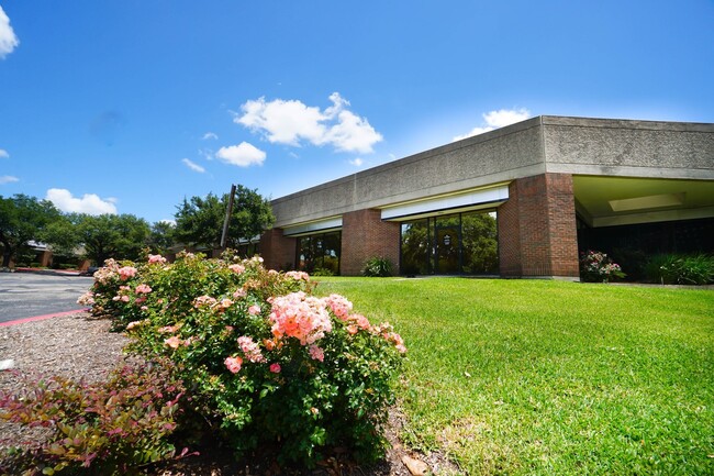
Property Record
2170 Woodward St, Austin, TX 78744


NEARBY LISTINGS FOR SALE OR LEASE
Property Detail
2170 Woodward St
Austin-Round Rock-San Marcos, TX
Crow Industrial Park South Sec 7
291761
LOT B CROW INDUSTRIAL PARK SOUTH SEC 7
Industrialgeneral
Travis
X
Texas
48453C0605K
b
2024
6.30 AC
2025
Southeast
002411
Austin
72,000 SF
DEMOGRAPHICS near 2170 Woodward St
1 mile
3 mile
5 mile
2024 Total Population
7,900
148,011
321,114
2029 Population
8,513
161,301
350,383
Pop Growth 2024-2029
+ 7.76%
+ 8.98%
+ 9.11%
Average Age
34
35
36
2024 Total Households
3,198
65,866
143,099
HH Growth 2024-2029
+ 8.32%
+ 9.81%
+ 10.05%
Median Household Inc
$47,658
$61,625
$75,808
Avg Household Size
2.40
2.10
2.10
2024 Avg HH Vehicles
2.00
2.00
2.00
Median Home Value
$329,464
$411,102
$446,092
Median Year Built
1985
1990
1997
Nearby Places
Map Layers
Map Styles
 Street
 Aerial
Transit
 Traffic
 Biking
Places
Listings with unknown addresses are not visible on the map
- Restaurants
- Banks
- Shops
- Fitness
- Groceries
PUBLIC TRANSPORTATION
COMMUTER RAIL
Austin (Texas Eagle - Amtrak)
Drive
Walk
Distance
Austin (Texas Eagle - Amtrak)
11 min
5.7 mi
AIRPORT
Austin-Bergstrom International
Drive
Walk
Distance
Austin-Bergstrom International
17 min
7.7 mi
Freight Ports
Calhoun Port
Drive
Walk
Distance
Calhoun Port
183 min
151.2 mi
SALE & LEASE HISTORY
LISTING DATE
SALE/LEASE

Nov 25, 2019
For Lease
Jun 16, 2020
For Lease
Nearby Properties
Address
Land Use
TOTAL SIZE
Lot Size
Zoning
Address
Land Use
TOTAL SIZE
Lot Size
Zoning
498,684 SF
61.86 AC
Address
Land Use
TOTAL SIZE
Lot Size
Zoning
999,200 SF
25 AC
Address
Land Use
TOTAL SIZE
Lot Size
Zoning
8,213 SF
36.95 AC
Address
Land Use
TOTAL SIZE
Lot Size
Zoning
8.17 AC
Address
Land Use
TOTAL SIZE
Lot Size
Zoning
368,349 SF
17.13 AC
Address
Land Use
TOTAL SIZE
Lot Size
Zoning
356,147 SF
10.48 AC
Address
Land Use
TOTAL SIZE
Lot Size
Zoning
492,715 SF
9.22 AC
Address
Land Use
TOTAL SIZE
Lot Size
Zoning
456,650 SF
15 AC
Address
Land Use
TOTAL SIZE
Lot Size
Zoning
307,610 SF
8.95 AC
Address
Land Use
TOTAL SIZE
Lot Size
Zoning
454,740 SF
27.77 AC
Address
Land Use
TOTAL SIZE
Lot Size
Zoning
387,267 SF
3.25 AC
Address
Land Use
TOTAL SIZE
Lot Size
Zoning
290,643 SF
13.59 AC
Address
Land Use
TOTAL SIZE
Lot Size
Zoning
316,847 SF
10.35 AC
Address
Land Use
TOTAL SIZE
Lot Size
Zoning
539,533 SF
26.50 AC
Address
Land Use
TOTAL SIZE
Lot Size
Zoning
558,324 SF
45.12 AC
Address
Land Use
TOTAL SIZE
Lot Size
Zoning
249,337 SF
2.71 AC
Address
Land Use
TOTAL SIZE
Lot Size
Zoning
4,944 SF
25.09 AC
Address
Land Use
TOTAL SIZE
Lot Size
Zoning
386,952 SF
6.77 AC
Address
Land Use
TOTAL SIZE
Lot Size
Zoning
335,913 SF
13.83 AC
Address
Land Use
TOTAL SIZE
Lot Size
Zoning
218,380 SF
6.37 AC
Address
Land Use
TOTAL SIZE
Lot Size
Zoning
272,084 SF
3.87 AC
Address
Land Use
TOTAL SIZE
Lot Size
Zoning
263,050 SF
4.04 AC
Address
Land Use
TOTAL SIZE
Lot Size
Zoning
256,182 SF
3.63 AC
Address
Land Use
TOTAL SIZE
Lot Size
Zoning
281,588 SF
6.29 AC
Address
Land Use
TOTAL SIZE
Lot Size
Zoning
266,871 SF
9.13 AC
Address
Land Use
TOTAL SIZE
Lot Size
Zoning
270,600 SF
3.90 AC
Address
Land Use
TOTAL SIZE
Lot Size
Zoning
319,275 SF
0.12 AC
Address
Land Use
TOTAL SIZE
Lot Size
Zoning
427,350 SF
3.63 AC
Address
Land Use
TOTAL SIZE
Lot Size
Zoning
372,125 SF
26.22 AC
Address
Land Use
TOTAL SIZE
Lot Size
Zoning
264,897 SF
2.54 AC
The World's #1 Commercial Real Estate Marketplace
Connect with us
© 2026 CoStar Group
The information above has been obtained from sources believed reliable. While we do not doubt its accuracy we have not verified it and make no guarantee, warranty or representation about it. It is your responsibility to independently confirm its accuracy and completeness. Any projections, opinions, assumptions, or estimates used are for example only and do not represent the current or future performance of the property. The value of this transaction to you depends on tax and other factors which should be evaluated by your tax, financial, and legal advisors. You and your advisors should conduct a careful, independent investigation of the property to determine to your satisfaction the suitability of the property for your needs.