Property Record
21900 E Quincy Ave, Aurora, CO 80015
NEARBY LISTINGS FOR SALE OR LEASE
Property Detail
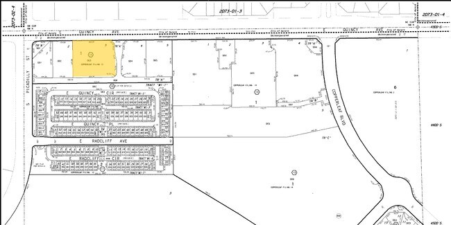
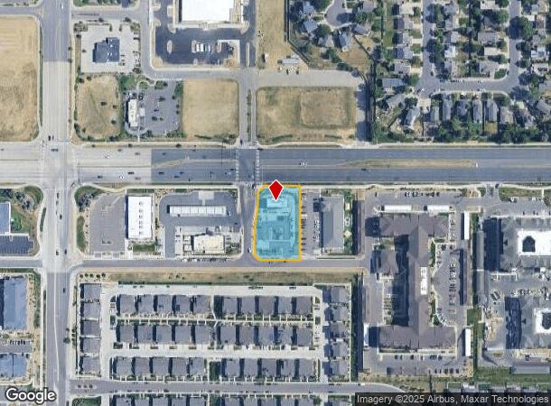
21900 E Quincy Ave
Denver-Aurora-Lakewood, CO
Copperleaf Flg No 16
2073-12-2-22-001
TOWNSHIP T5S MAPPLATB 524 MAPPLATP 73 SUBDIVISIONCD 017501 SUBDIVISIONNAME COPPERLEAF FLG NO 16 BLOCK 001 LOT 001 LOT 1 BLK 1 COPPERLEAF FLG NO 16 EX MRS
Restaurantbuilding
Arapahoe
X
Colorado
08005C0213M
1
2023
0.83 AC
2024
Southeast
085900
Denver
2,160 SF
DEMOGRAPHICS near 21900 E Quincy Ave
1 Mile
3 Mile
5 Mile
2024 Total Population
16,220
102,132
230,674
2029 Population
16,739
102,250
230,982
Pop Growth 2024-2029
+ 3.20%
+ 0.12%
+ 0.13%
Average Age
34
37
38
2024 Total Households
4,722
33,111
78,820
HH Growth 2024-2029
+ 3.05%
(0.02%)
+ 0.04%
Median Household Inc
$129,379
$113,542
$106,756
Avg Household Size
3.40
3.00
2.90
2024 Avg HH Vehicles
2.00
2.00
2.00
Median Home Value
$502,023
$468,418
$472,277
Median Year Built
2009
1996
1993
Nearby Places
Map Layers
Map Styles
 Street
 Aerial
- Restaurants
- Banks
- Shops
- Fitness
- Groceries
PUBLIC TRANSPORTATION
AIRPORT
Denver International
DRIVE
WALK
Distance
Denver International
25 min
21.3 mi
Freight Ports
Tulsa Port Of Catoosa
DRIVE
WALK
Distance
Tulsa Port Of Catoosa
717 min
701.2 mi
Nearby Properties
Address
Land Use
TOTAL SIZE
Lot Size
Zoning
Address
Land Use
TOTAL SIZE
Lot Size
Zoning
328,000 SF
33.52 AC
PUD
Address
Land Use
TOTAL SIZE
Lot Size
Zoning
368,462 SF
11.68 AC
RZMF
Address
Land Use
TOTAL SIZE
Lot Size
Zoning
129,701 SF
6.56 AC
Address
Land Use
TOTAL SIZE
Lot Size
Zoning
168,500 SF
24.03 AC
Address
Land Use
TOTAL SIZE
Lot Size
Zoning
489,120 SF
20.10 AC
RE470
Address
Land Use
TOTAL SIZE
Lot Size
Zoning
142,378 SF
14.64 AC
Address
Land Use
TOTAL SIZE
Lot Size
Zoning
40,935 SF
3.38 AC
RE470
Address
Land Use
TOTAL SIZE
Lot Size
Zoning
376,563 SF
12.17 AC
AMU
Address
Land Use
TOTAL SIZE
Lot Size
Zoning
310,926 SF
23.13 AC
AMU
Address
Land Use
TOTAL SIZE
Lot Size
Zoning
319,078 SF
18.49 AC
RE470
Address
Land Use
TOTAL SIZE
Lot Size
Zoning
105,244 SF
12.64 AC
RPCZD
Address
Land Use
TOTAL SIZE
Lot Size
Zoning
14,600 SF
0.28 AC
WDC2A*
Address
Land Use
TOTAL SIZE
Lot Size
Zoning
137,372 SF
5.86 AC
Address
Land Use
TOTAL SIZE
Lot Size
Zoning
176,000 SF
10.83 AC
PUD
Address
Land Use
TOTAL SIZE
Lot Size
Zoning
206,064 SF
25.38 AC
AMU
Address
Land Use
TOTAL SIZE
Lot Size
Zoning
379,109 SF
16.45 AC
Address
Land Use
TOTAL SIZE
Lot Size
Zoning
151,246 SF
13.25 AC
RE470
Address
Land Use
TOTAL SIZE
Lot Size
Zoning
206,122 SF
24.97 AC
Address
Land Use
TOTAL SIZE
Lot Size
Zoning
255,676 SF
13.97 AC
PUD
Address
Land Use
TOTAL SIZE
Lot Size
Zoning
85,908 SF
2.71 AC
Address
Land Use
TOTAL SIZE
Lot Size
Zoning
140,000 SF
24.16 AC
AMU
Address
Land Use
TOTAL SIZE
Lot Size
Zoning
27.32 AC
Address
Land Use
TOTAL SIZE
Lot Size
Zoning
70,715 SF
13.57 AC
Address
Land Use
TOTAL SIZE
Lot Size
Zoning
55,800 SF
12.80 AC
Address
Land Use
TOTAL SIZE
Lot Size
Zoning
19.39 AC
PUD
Address
Land Use
TOTAL SIZE
Lot Size
Zoning
91,380 SF
5.52 AC
Address
Land Use
TOTAL SIZE
Lot Size
Zoning
182,199 SF
6.01 AC
Address
Land Use
TOTAL SIZE
Lot Size
Zoning
77,546 SF
4.82 AC
Address
Land Use
TOTAL SIZE
Lot Size
Zoning
15.04 AC
Address
Land Use
TOTAL SIZE
Lot Size
Zoning
52,800 SF
11.51 AC
The World's #1 Commercial Real Estate Marketplace
Connect with us
© 2025 CoStar Group
The information above has been obtained from sources believed reliable. While we do not doubt its accuracy we have not verified it and make no guarantee, warranty or representation about it. It is your responsibility to independently confirm its accuracy and completeness. Any projections, opinions, assumptions, or estimates used are for example only and do not represent the current or future performance of the property. The value of this transaction to you depends on tax and other factors which should be evaluated by your tax, financial, and legal advisors. You and your advisors should conduct a careful, independent investigation of the property to determine to your satisfaction the suitability of the property for your needs.