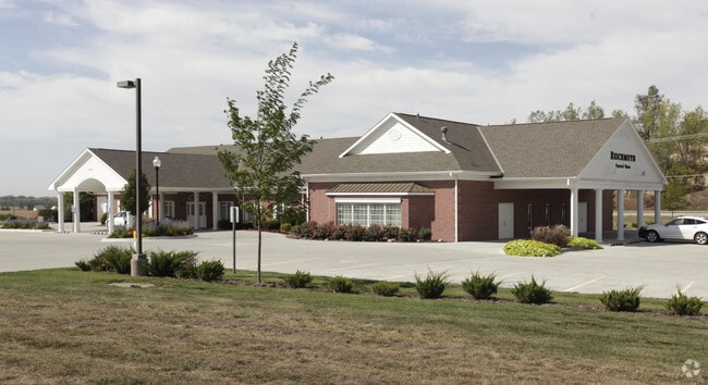
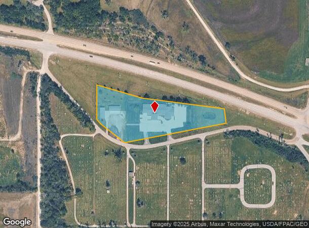
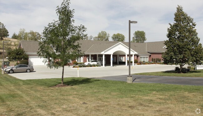
Property Record
21901 W Maple Rd, Elkhorn, NE 68022
NEARBY LISTINGS FOR SALE OR LEASE
Property Detail
21901 W Maple Rd
Omaha, NE-IA
Reichmuth Add
1410-8000-21
REICHMUTH ADD LOT 1 BLOCK 0 IRREG 3.313 AC
Funeralhome
Douglas
X
Nebraska
31055C0170K
1
2024
3.31 AC
2025
Northwest Omaha
007506
Omaha/Council Bluffs
9,602 SF
DEMOGRAPHICS near 21901 W Maple Rd
1 Mile
3 Mile
5 Mile
2024 Total Population
1,715
21,230
68,789
2029 Population
1,724
21,896
70,537
Pop Growth 2024-2029
+ 0.52%
+ 3.14%
+ 2.54%
Average Age
36
37
38
2024 Total Households
572
7,894
24,598
HH Growth 2024-2029
+ 0.70%
+ 3.27%
+ 2.55%
Median Household Inc
$109,179
$107,918
$126,732
Avg Household Size
2.90
2.60
2.80
2024 Avg HH Vehicles
2.00
2.00
2.00
Median Home Value
$321,631
$356,631
$372,504
Median Year Built
1992
2007
2007
Nearby Places
Map Layers
Map Styles
 Street
 Aerial
- Restaurants
- Banks
- Shops
- Fitness
- Groceries
PUBLIC TRANSPORTATION
AIRPORT
Eppley Airfield
DRIVE
WALK
Distance
Eppley Airfield
39 min
21.8 mi
Nearby Properties
Address
Land Use
TOTAL SIZE
Lot Size
Zoning
Address
Land Use
TOTAL SIZE
Lot Size
Zoning
443,045 SF
22.82 AC
Address
Land Use
TOTAL SIZE
Lot Size
Zoning
486,568 SF
51.70 AC
ELKHORN
Address
Land Use
TOTAL SIZE
Lot Size
Zoning
362,573 SF
2.01 AC
Address
Land Use
TOTAL SIZE
Lot Size
Zoning
226,792 SF
8.97 AC
GO
Address
Land Use
TOTAL SIZE
Lot Size
Zoning
215,645 SF
5.19 AC
Address
Land Use
TOTAL SIZE
Lot Size
Zoning
233,520 SF
15.39 AC
Address
Land Use
TOTAL SIZE
Lot Size
Zoning
355,421 SF
18.66 AC
Address
Land Use
TOTAL SIZE
Lot Size
Zoning
149,113 SF
7.64 AC
R6
Address
Land Use
TOTAL SIZE
Lot Size
Zoning
241,480 SF
9.54 AC
Address
Land Use
TOTAL SIZE
Lot Size
Zoning
272,916 SF
27.09 AC
Address
Land Use
TOTAL SIZE
Lot Size
Zoning
134,188 SF
6.05 AC
Address
Land Use
TOTAL SIZE
Lot Size
Zoning
164,725 SF
11.57 AC
Address
Land Use
TOTAL SIZE
Lot Size
Zoning
144,450 SF
3.97 AC
Address
Land Use
TOTAL SIZE
Lot Size
Zoning
162,300 SF
17.46 AC
Address
Land Use
TOTAL SIZE
Lot Size
Zoning
144,006 SF
5.86 AC
Address
Land Use
TOTAL SIZE
Lot Size
Zoning
132,938 SF
7.76 AC
Address
Land Use
TOTAL SIZE
Lot Size
Zoning
106,857 SF
4.97 AC
Address
Land Use
TOTAL SIZE
Lot Size
Zoning
70,888 SF
6.31 AC
R6
Address
Land Use
TOTAL SIZE
Lot Size
Zoning
114,371 SF
3.12 AC
Address
Land Use
TOTAL SIZE
Lot Size
Zoning
117,761 SF
3.45 AC
Address
Land Use
TOTAL SIZE
Lot Size
Zoning
116,987 SF
4.90 AC
Address
Land Use
TOTAL SIZE
Lot Size
Zoning
43,266 SF
2.01 AC
GC
Address
Land Use
TOTAL SIZE
Lot Size
Zoning
92,864 SF
10.76 AC
Address
Land Use
TOTAL SIZE
Lot Size
Zoning
109,400 SF
4.76 AC
CC
Address
Land Use
TOTAL SIZE
Lot Size
Zoning
109,698 SF
4.35 AC
CC
Address
Land Use
TOTAL SIZE
Lot Size
Zoning
64,948 SF
4.87 AC
CC
Address
Land Use
TOTAL SIZE
Lot Size
Zoning
61,850 SF
1.31 AC
Address
Land Use
TOTAL SIZE
Lot Size
Zoning
83,958 SF
2.22 AC
Address
Land Use
TOTAL SIZE
Lot Size
Zoning
53,440 SF
1.90 AC
Address
Land Use
TOTAL SIZE
Lot Size
Zoning
53,294 SF
3.27 AC
The World's #1 Commercial Real Estate Marketplace
Connect with us
© 2026 CoStar Group
The information above has been obtained from sources believed reliable. While we do not doubt its accuracy we have not verified it and make no guarantee, warranty or representation about it. It is your responsibility to independently confirm its accuracy and completeness. Any projections, opinions, assumptions, or estimates used are for example only and do not represent the current or future performance of the property. The value of this transaction to you depends on tax and other factors which should be evaluated by your tax, financial, and legal advisors. You and your advisors should conduct a careful, independent investigation of the property to determine to your satisfaction the suitability of the property for your needs.