Property Record
21910 E 71St St S, Broken Arrow, OK 74014
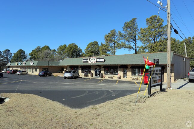

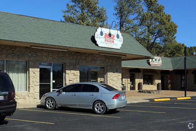
Property Detail
21910 E 71St St S
Tulsa, OK
PINE AC COMMERCIAL LOT 15 SHOPPING CENTER
730007620
Wagoner
Stripcommercialcenter
Oklahoma
B and X Area of moderate flood hazard, usually the area between the limits of the 100-year and 500-year floods.
15
2025
1.50 AC
2025
Wagoner County
030506
Tulsa
15,060 SF
NEARBY LISTINGS FOR SALE OR LEASE
-
-
-
-
-
-
Northwest Corner of E Albany & County Line Rd
Broken Arrow, OK 74012
$34.00 - $36.00 SF/YR
1,500 - 5,112 SF
Retail
-
-
View all Broken Arrow listings for sale on LoopNet.com
DEMOGRAPHICS near 21910 E 71St St S
1 mile
3 mile
5 mile
2025 Total Population
2,349
32,417
92,125
2030 Population
2,566
35,009
97,899
Pop Growth 2025-2030
+ 9.24%
+ 8.00%
+ 6.27%
Average Age
42
39
38
2025 Total Households
822
12,016
34,479
HH Growth 2025-2030
+ 8.88%
+ 7.71%
+ 6.04%
Median Household Inc
$97,742
$86,716
$86,404
Avg Household Size
2.80
2.60
2.60
2025 Avg HH Vehicles
2.00
2.00
2.00
Median Home Value
$276,892
$258,917
$258,639
Median Year Built
1979
1999
1999
Nearby Places
Map Layers
Map Styles
 Street
 Aerial
Layers
 Traffic
 Biking
Places
Listings with unknown addresses are not visible on the map
- Restaurants
- Banks
- Shops
- Fitness
- Groceries
PUBLIC TRANSPORTATION
AIRPORT
Tulsa International
Drive
Walk
Distance
Tulsa International
27 min
18.8 mi
Freight Ports
Drive
Walk
Distance
21 min
15.6 mi
Nearby Properties
Address
Land Use
TOTAL SIZE
Lot Size
Zoning
Address
Land Use
TOTAL SIZE
Lot Size
Zoning
75,444 SF
23.92 AC
R1
Address
Land Use
TOTAL SIZE
Lot Size
Zoning
58,695 SF
5.34 AC
RM
Address
Land Use
TOTAL SIZE
Lot Size
Zoning
363,154 SF
23.09 AC
IL
Address
Land Use
TOTAL SIZE
Lot Size
Zoning
13,691 SF
2.04 AC
CH
Address
Land Use
TOTAL SIZE
Lot Size
Zoning
28,071 SF
19 AC
Address
Land Use
TOTAL SIZE
Lot Size
Zoning
51,741 SF
2.41 AC
R3
Address
Land Use
TOTAL SIZE
Lot Size
Zoning
60,460 SF
2.28 AC
NCU
Address
Land Use
TOTAL SIZE
Lot Size
Zoning
10,140 SF
18.57 AC
R1
Address
Land Use
TOTAL SIZE
Lot Size
Zoning
27,477 SF
5.79 AC
R1
Address
Land Use
TOTAL SIZE
Lot Size
Zoning
11,605 SF
1.50 AC
OL
Address
Land Use
TOTAL SIZE
Lot Size
Zoning
286,516 SF
22.63 AC
RM
Address
Land Use
TOTAL SIZE
Lot Size
Zoning
255,328 SF
27.50 AC
IL
Address
Land Use
TOTAL SIZE
Lot Size
Zoning
Address
Land Use
TOTAL SIZE
Lot Size
Zoning
10,700 SF
5.99 AC
RM
Address
Land Use
TOTAL SIZE
Lot Size
Zoning
11,795 SF
5.12 AC
R1
Address
Land Use
TOTAL SIZE
Lot Size
Zoning
74,293 SF
9.34 AC
CH
Address
Land Use
TOTAL SIZE
Lot Size
Zoning
181,322 SF
18.06 AC
RM
Address
Land Use
TOTAL SIZE
Lot Size
Zoning
72,754 SF
9.18 AC
CH
Address
Land Use
TOTAL SIZE
Lot Size
Zoning
18,275 SF
0.68 AC
R2
Address
Land Use
TOTAL SIZE
Lot Size
Zoning
16,623 SF
4.28 AC
R2
Address
Land Use
TOTAL SIZE
Lot Size
Zoning
27,034 SF
2.60 AC
A1
Address
Land Use
TOTAL SIZE
Lot Size
Zoning
145,261 SF
14.09 AC
CH
Address
Land Use
TOTAL SIZE
Lot Size
Zoning
125,153 SF
11.65 AC
CH
Address
Land Use
TOTAL SIZE
Lot Size
Zoning
5,920 SF
10.77 AC
Address
Land Use
TOTAL SIZE
Lot Size
Zoning
18,820 SF
13.42 AC
Address
Land Use
TOTAL SIZE
Lot Size
Zoning
28,518 SF
3.86 AC
CG
Address
Land Use
TOTAL SIZE
Lot Size
Zoning
7,200 SF
24.37 AC
Address
Land Use
TOTAL SIZE
Lot Size
Zoning
62,394 SF
9.01 AC
The World's #1 Commercial Real Estate Marketplace
Connect with us
© 2026 CoStar Group
The information above has been obtained from sources believed reliable. While we do not doubt its accuracy we have not verified it and make no guarantee, warranty or representation about it. It is your responsibility to independently confirm its accuracy and completeness. Any projections, opinions, assumptions, or estimates used are for example only and do not represent the current or future performance of the property. The value of this transaction to you depends on tax and other factors which should be evaluated by your tax, financial, and legal advisors. You and your advisors should conduct a careful, independent investigation of the property to determine to your satisfaction the suitability of the property for your needs.