Property Record
22 Hubbard Rd, Wilton, CT 06897

NEARBY LISTINGS FOR SALE OR LEASE
Property Detail
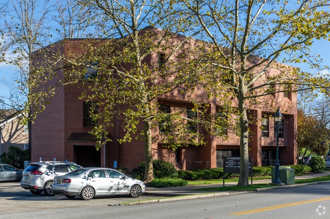
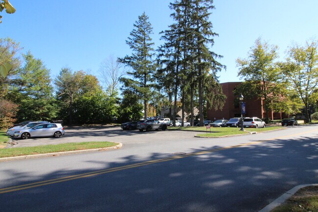
22 Hubbard Rd
Bridgeport-Stamford-Danbury, CT
Godfrey Place
WILT M:0073 B:033 L:00
Fairfield
Commercialnec
Connecticut
2025
0.63 AC
2025
Wilton
045200
Westchester/So Connecticut
11,162 SF
DEMOGRAPHICS near 22 Hubbard Rd
1 mile
3 mile
5 mile
2024 Total Population
2,803
21,937
84,134
2029 Population
2,831
22,006
84,358
Pop Growth 2024-2029
+ 1.00%
+ 0.31%
+ 0.27%
Average Age
42
41
41
2024 Total Households
1,057
7,666
30,471
HH Growth 2024-2029
+ 1.04%
+ 0.33%
+ 0.22%
Median Household Inc
$171,221
$205,431
$163,709
Avg Household Size
2.60
2.80
2.70
2024 Avg HH Vehicles
2.00
2.00
2.00
Median Home Value
$694,018
$789,672
$766,059
Median Year Built
1981
1970
1967
Nearby Places
Map Layers
Map Styles
 Street
 Aerial
Transit
 Traffic
 Biking
Places
Listings with unknown addresses are not visible on the map
- Restaurants
- Banks
- Shops
- Fitness
- Groceries
PUBLIC TRANSPORTATION
TRANSIT/SUBWAY
Wilton Station (New Haven Line - Metro-North Commuter Railroad Company (Metro-North))
Drive
Walk
Distance
Wilton Station (New Haven Line - Metro-North Commuter Railroad Company (Metro-North))
3 min
10 min
0.5 mi
COMMUTER RAIL
Wilton Station (New Haven Line - Metro-North Commuter Railroad Company (Metro-North))
Drive
Walk
Distance
Wilton Station (New Haven Line - Metro-North Commuter Railroad Company (Metro-North))
3 min
8 min
0.4 mi
Cannondale Station (New Haven Line - Metro-North Commuter Railroad Company (Metro-North))
Drive
Walk
Distance
Cannondale Station (New Haven Line - Metro-North Commuter Railroad Company (Metro-North))
5 min
2.2 mi
AIRPORT
Westchester County
Drive
Walk
Distance
Westchester County
40 min
25.7 mi
Tweed/New Haven
Drive
Walk
Distance
Tweed/New Haven
59 min
36.6 mi
Freight Ports
Port of New Haven
Drive
Walk
Distance
Port of New Haven
53 min
34.4 mi
SALE & LEASE HISTORY
LISTING DATE
SALE/LEASE

Sep 24, 2016
For Lease
May 24, 2017
For Lease
Jun 09, 2017
For Lease
Jul 19, 2017
For Sale
Jan 24, 2022
For Sale
Jan 03, 2018
For Lease
Jan 03, 2018
For Sale
Apr 26, 2021
For Sale
Nearby Properties
Address
Land Use
TOTAL SIZE
Lot Size
Zoning
Address
Land Use
TOTAL SIZE
Lot Size
Zoning
28.64 AC
DE-10
Address
Land Use
TOTAL SIZE
Lot Size
Zoning
82.14 AC
R-2
Address
Land Use
TOTAL SIZE
Lot Size
Zoning
292,852 SF
3.38 AC
EO
Address
Land Use
TOTAL SIZE
Lot Size
Zoning
254,126 SF
3.33 AC
EO
Address
Land Use
TOTAL SIZE
Lot Size
Zoning
109.27 AC
R-2
Address
Land Use
TOTAL SIZE
Lot Size
Zoning
254,126 SF
3.06 AC
EO
Address
Land Use
TOTAL SIZE
Lot Size
Zoning
196,084 SF
4.34 AC
DE-5
Address
Land Use
TOTAL SIZE
Lot Size
Zoning
21.34 AC
B2
Address
Land Use
TOTAL SIZE
Lot Size
Zoning
24.67 AC
DE-10
Address
Land Use
TOTAL SIZE
Lot Size
Zoning
12.32 AC
CRA-1
Address
Land Use
TOTAL SIZE
Lot Size
Zoning
34.16 AC
R-2
Address
Land Use
TOTAL SIZE
Lot Size
Zoning
10.64 AC
HODD
Address
Land Use
TOTAL SIZE
Lot Size
Zoning
214,890 SF
2.91 AC
EO
Address
Land Use
TOTAL SIZE
Lot Size
Zoning
32.55 AC
DE-10
Address
Land Use
TOTAL SIZE
Lot Size
Zoning
33.70 AC
R-2
Address
Land Use
TOTAL SIZE
Lot Size
Zoning
219,944 SF
2 AC
EO
Address
Land Use
TOTAL SIZE
Lot Size
Zoning
206,490 SF
1 AC
DE-5
Address
Land Use
TOTAL SIZE
Lot Size
Zoning
11.14 AC
B2
Address
Land Use
TOTAL SIZE
Lot Size
Zoning
11 AC
DE-5
Address
Land Use
TOTAL SIZE
Lot Size
Zoning
206,774 SF
3.57 AC
EO
Address
Land Use
TOTAL SIZE
Lot Size
Zoning
134.24 AC
A3
Address
Land Use
TOTAL SIZE
Lot Size
Zoning
7.61 AC
WC
Address
Land Use
TOTAL SIZE
Lot Size
Zoning
8.92 AC
R-2
Address
Land Use
TOTAL SIZE
Lot Size
Zoning
77,212 SF
DE-5
Address
Land Use
TOTAL SIZE
Lot Size
Zoning
7.10 AC
DRB
Address
Land Use
TOTAL SIZE
Lot Size
Zoning
3.46 AC
B2
Address
Land Use
TOTAL SIZE
Lot Size
Zoning
42,892 SF
38.62 AC
A3
Address
Land Use
TOTAL SIZE
Lot Size
Zoning
86,393 SF
0.84 AC
B2
Address
Land Use
TOTAL SIZE
Lot Size
Zoning
75,656 SF
3.81 AC
R-1
Address
Land Use
TOTAL SIZE
Lot Size
Zoning
10.84 AC
DE-5
The World's #1 Commercial Real Estate Marketplace
Connect with us
© 2026 CoStar Group
The information above has been obtained from sources believed reliable. While we do not doubt its accuracy we have not verified it and make no guarantee, warranty or representation about it. It is your responsibility to independently confirm its accuracy and completeness. Any projections, opinions, assumptions, or estimates used are for example only and do not represent the current or future performance of the property. The value of this transaction to you depends on tax and other factors which should be evaluated by your tax, financial, and legal advisors. You and your advisors should conduct a careful, independent investigation of the property to determine to your satisfaction the suitability of the property for your needs.