Property Record
220 Echo Dr, Birmingham, AL 35214
NEARBY LISTINGS FOR SALE OR LEASE
Property Detail
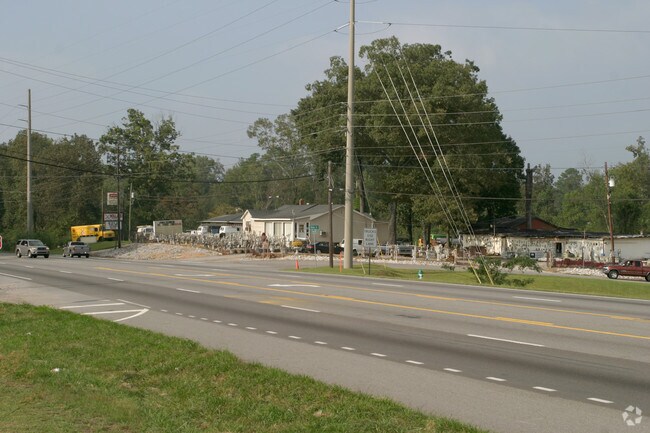
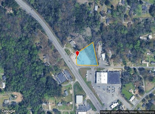
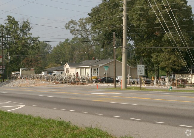
220 Echo Dr
Birmingham, AL
Marlowe James E-Ri 22-7-3
22-00-07-3-005-015.000
P O B N INTER ECHO DR & U S HWY 78 TH NW 135 FT S ALG U S HWY 78 TH NE 321.7 FT TH SE 300 FT S TO ECHO DR TH W 254 FT S ALG ECHO DR TO P O B BEING PT LOT 7 JAMES E MARLOWE ADD TO RIDERWOOD PARK
Vacantlandnec
Jefferson
X
Alabama
01073C0359H
7
2023
1.40 AC
2024
Bessemer
0124011016
Birmingham
DEMOGRAPHICS near 220 Echo Dr
1 Mile
3 Mile
5 Mile
2024 Total Population
3,623
18,374
52,007
2029 Population
3,519
18,025
51,821
Pop Growth 2024-2029
(2.87%)
(1.90%)
(0.36%)
Average Age
42
42
42
2024 Total Households
1,440
7,363
21,164
HH Growth 2024-2029
(2.92%)
(2.00%)
(0.27%)
Median Household Inc
$62,921
$54,604
$43,551
Avg Household Size
2.40
2.40
2.30
2024 Avg HH Vehicles
2.00
2.00
2.00
Median Home Value
$150,897
$142,351
$111,689
Median Year Built
1967
1973
1967
Nearby Places
Map Layers
Map Styles
 Street
 Aerial
- Restaurants
- Banks
- Shops
- Fitness
- Groceries
PUBLIC TRANSPORTATION
COMMUTER RAIL
Birmingham (Crescent - Amtrak)
DRIVE
WALK
Distance
Birmingham (Crescent - Amtrak)
13 min
8.0 mi
AIRPORT
Birmingham-Shuttlesworth International
DRIVE
WALK
Distance
Birmingham-Shuttlesworth International
20 min
12.9 mi
Freight Ports
Port of Mobile
DRIVE
WALK
Distance
Port of Mobile
289 min
262.4 mi
Nearby Properties
Address
Land Use
TOTAL SIZE
Lot Size
Zoning
Address
Land Use
TOTAL SIZE
Lot Size
Zoning
32,922 SF
15 AC
I3
Address
Land Use
TOTAL SIZE
Lot Size
Zoning
181,399 SF
20.91 AC
A1
Address
Land Use
TOTAL SIZE
Lot Size
Zoning
137,177 SF
10 AC
INST
Address
Land Use
TOTAL SIZE
Lot Size
Zoning
123,937 SF
7.79 AC
R4
Address
Land Use
TOTAL SIZE
Lot Size
Zoning
31,817 SF
2.17 AC
CP-C
Address
Land Use
TOTAL SIZE
Lot Size
Zoning
109,753 SF
6.18 AC
R5
Address
Land Use
TOTAL SIZE
Lot Size
Zoning
49,235 SF
9.90 AC
R7/P
Address
Land Use
TOTAL SIZE
Lot Size
Zoning
46,584 SF
14.50 AC
R4
Address
Land Use
TOTAL SIZE
Lot Size
Zoning
45,661 SF
6.40 AC
I3
Address
Land Use
TOTAL SIZE
Lot Size
Zoning
44,194 SF
3 AC
I
Address
Land Use
TOTAL SIZE
Lot Size
Zoning
87,260 SF
8.20 AC
A1-C
Address
Land Use
TOTAL SIZE
Lot Size
Zoning
33,516 SF
2.95 AC
R4
Address
Land Use
TOTAL SIZE
Lot Size
Zoning
82,172 SF
4.39 AC
R4
Address
Land Use
TOTAL SIZE
Lot Size
Zoning
46,492 SF
4.62 AC
A1-C
Address
Land Use
TOTAL SIZE
Lot Size
Zoning
40,000 SF
6.01 AC
I3
Address
Land Use
TOTAL SIZE
Lot Size
Zoning
31,438 SF
8 AC
B2
Address
Land Use
TOTAL SIZE
Lot Size
Zoning
26,458 SF
3.88 AC
INST
Address
Land Use
TOTAL SIZE
Lot Size
Zoning
54,544 SF
30 AC
M3
Address
Land Use
TOTAL SIZE
Lot Size
Zoning
57,685 SF
6.70 AC
I3
Address
Land Use
TOTAL SIZE
Lot Size
Zoning
34,498 SF
4.70 AC
INST
Address
Land Use
TOTAL SIZE
Lot Size
Zoning
37,100 SF
22.70 AC
INST
Address
Land Use
TOTAL SIZE
Lot Size
Zoning
16,219 SF
5.77 AC
INST
Address
Land Use
TOTAL SIZE
Lot Size
Zoning
1,200 SF
8.30 AC
A1
Address
Land Use
TOTAL SIZE
Lot Size
Zoning
30,693 SF
12 AC
INST
Address
Land Use
TOTAL SIZE
Lot Size
Zoning
16,268 SF
1.32 AC
QR6
Address
Land Use
TOTAL SIZE
Lot Size
Zoning
47,248 SF
17.51 AC
C1-A
Address
Land Use
TOTAL SIZE
Lot Size
Zoning
26,114 SF
1.72 AC
C1
Address
Land Use
TOTAL SIZE
Lot Size
Zoning
26,364 SF
3.50 AC
IN
Address
Land Use
TOTAL SIZE
Lot Size
Zoning
42,642 SF
6 AC
A1-C
Address
Land Use
TOTAL SIZE
Lot Size
Zoning
24,566 SF
2 AC
R1
The World's #1 Commercial Real Estate Marketplace
Connect with us
© 2026 CoStar Group
The information above has been obtained from sources believed reliable. While we do not doubt its accuracy we have not verified it and make no guarantee, warranty or representation about it. It is your responsibility to independently confirm its accuracy and completeness. Any projections, opinions, assumptions, or estimates used are for example only and do not represent the current or future performance of the property. The value of this transaction to you depends on tax and other factors which should be evaluated by your tax, financial, and legal advisors. You and your advisors should conduct a careful, independent investigation of the property to determine to your satisfaction the suitability of the property for your needs.