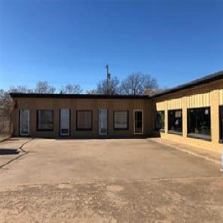
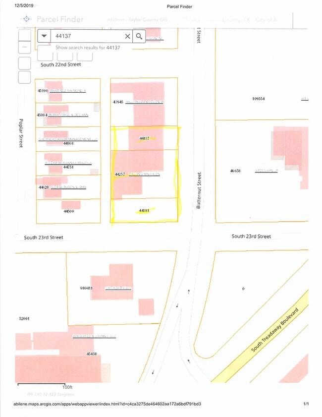
Property Record
2202 Butternut St, Abilene, TX 79602
Property Detail
2202 Butternut St
Abilene, TX
BOWYER ADDN, BLOCK 6, LOT 4 & 5
43945
TAYLOR
Multipleuses
Texas
B and X Area of moderate flood hazard, usually the area between the limits of the 100-year and 500-year floods.
4,5
2024
0.32 AC
2025
Abilene
012200
Other Market Areas
6,400 SF
NEARBY LISTINGS FOR SALE OR LEASE
DEMOGRAPHICS near 2202 Butternut St
1 mile
3 mile
5 mile
2025 Total Population
7,659
59,667
114,913
2030 Population
7,976
61,540
118,959
Pop Growth 2025-2030
+ 4.14%
+ 3.14%
+ 3.52%
Average Age
37
38
37
2025 Total Households
2,744
24,271
44,184
HH Growth 2025-2030
+ 4.30%
+ 3.25%
+ 3.64%
Median Household Inc
$54,020
$60,374
$58,783
Avg Household Size
2.40
2.30
2.40
2025 Avg HH Vehicles
2.00
2.00
2.00
Median Home Value
$134,099
$182,126
$183,886
Median Year Built
1955
1968
1973
Nearby Places
Map Layers
Map Styles
 Street
 Aerial
Transit
 Traffic
 Biking
Places
Listings with unknown addresses are not visible on the map
- Restaurants
- Banks
- Shops
- Fitness
- Groceries
PUBLIC TRANSPORTATION
AIRPORT
Abilene Regional
Drive
Walk
Distance
Abilene Regional
12 min
5.8 mi
Freight Ports
Calhoun Port
Drive
Walk
Distance
Calhoun Port
434 min
372.5 mi
SALE & LEASE HISTORY
LISTING DATE
SALE/LEASE

Jul 03, 2019
For Sale
Dec 04, 2019
For Sale
Nearby Properties
Address
Land Use
TOTAL SIZE
Lot Size
Zoning
Address
Land Use
TOTAL SIZE
Lot Size
Zoning
241,730 SF
51.89 AC
Address
Land Use
TOTAL SIZE
Lot Size
Zoning
169,821 SF
3.59 AC
Address
Land Use
TOTAL SIZE
Lot Size
Zoning
600,001 SF
39.40 AC
Address
Land Use
TOTAL SIZE
Lot Size
Zoning
411,104 SF
91.21 AC
Address
Land Use
TOTAL SIZE
Lot Size
Zoning
256,877 SF
11.04 AC
Address
Land Use
TOTAL SIZE
Lot Size
Zoning
129,462 SF
69.58 AC
Address
Land Use
TOTAL SIZE
Lot Size
Zoning
115,568 SF
23.57 AC
Address
Land Use
TOTAL SIZE
Lot Size
Zoning
421,730 SF
30.12 AC
Address
Land Use
TOTAL SIZE
Lot Size
Zoning
162,480 SF
9.88 AC
Address
Land Use
TOTAL SIZE
Lot Size
Zoning
114,617 SF
23.73 AC
Address
Land Use
TOTAL SIZE
Lot Size
Zoning
180,936 SF
31.23 AC
Address
Land Use
TOTAL SIZE
Lot Size
Zoning
143,845 SF
11.47 AC
Address
Land Use
TOTAL SIZE
Lot Size
Zoning
620,165 SF
107.40 AC
Address
Land Use
TOTAL SIZE
Lot Size
Zoning
166,901 SF
14.71 AC
Address
Land Use
TOTAL SIZE
Lot Size
Zoning
166,224 SF
8.79 AC
Address
Land Use
TOTAL SIZE
Lot Size
Zoning
70,076 SF
24.79 AC
Address
Land Use
TOTAL SIZE
Lot Size
Zoning
195,960 SF
11.07 AC
Address
Land Use
TOTAL SIZE
Lot Size
Zoning
182,328 SF
10.93 AC
Address
Land Use
TOTAL SIZE
Lot Size
Zoning
187,944 SF
8.69 AC
Address
Land Use
TOTAL SIZE
Lot Size
Zoning
200,648 SF
8.98 AC
Address
Land Use
TOTAL SIZE
Lot Size
Zoning
342,750 SF
34.54 AC
Address
Land Use
TOTAL SIZE
Lot Size
Zoning
195,544 SF
11 AC
Address
Land Use
TOTAL SIZE
Lot Size
Zoning
73,947 SF
9.89 AC
Address
Land Use
TOTAL SIZE
Lot Size
Zoning
71,515 SF
9.94 AC
Address
Land Use
TOTAL SIZE
Lot Size
Zoning
84,335 SF
4.68 AC
Address
Land Use
TOTAL SIZE
Lot Size
Zoning
79,879 SF
2.86 AC
Address
Land Use
TOTAL SIZE
Lot Size
Zoning
62,823 SF
9.39 AC
Address
Land Use
TOTAL SIZE
Lot Size
Zoning
80,574 SF
4.20 AC
Address
Land Use
TOTAL SIZE
Lot Size
Zoning
101,812 SF
6.28 AC
Address
Land Use
TOTAL SIZE
Lot Size
Zoning
146,819 SF
9.75 AC
The World's #1 Commercial Real Estate Marketplace
Connect with us
© 2026 CoStar Group
The information above has been obtained from sources believed reliable. While we do not doubt its accuracy we have not verified it and make no guarantee, warranty or representation about it. It is your responsibility to independently confirm its accuracy and completeness. Any projections, opinions, assumptions, or estimates used are for example only and do not represent the current or future performance of the property. The value of this transaction to you depends on tax and other factors which should be evaluated by your tax, financial, and legal advisors. You and your advisors should conduct a careful, independent investigation of the property to determine to your satisfaction the suitability of the property for your needs.