Property Record
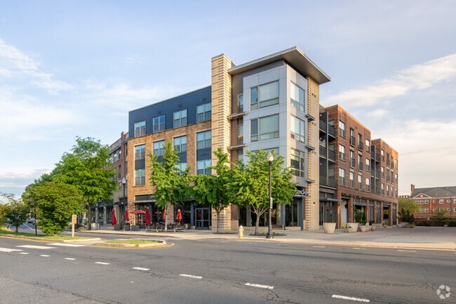
2201 N Pershing Dr, Arlington, VA 22201

Property Detail
2201 N Pershing Dr
18-038-025
PARCEL A 2201 PERSHING 125133 SQ FT
Apartment
Arlington
C-O-1.0/C-
Virginia
B and X Area of moderate flood hazard, usually the area between the limits of the 100-year and 500-year floods.
2.87 AC
2025
Clarendon/Courthouse
2025
Washington, DC
101803
Washington-Arlington-Alexandria, DC-VA-MD-WV
33,495 SF
NEARBY LISTINGS FOR SALE OR LEASE
DEMOGRAPHICS near 2201 N Pershing Dr
1 mile
3 mile
5 mile
2025 Total Population
40,989
271,643
759,412
2030 Population
42,544
281,991
793,947
Pop Growth 2025-2030
+ 3.79%
+ 3.81%
+ 4.55%
Average Age
36
37
38
2025 Total Households
20,742
127,785
363,385
HH Growth 2025-2030
+ 3.95%
+ 4.14%
+ 5.20%
Median Household Inc
$146,653
$132,887
$133,182
Avg Household Size
1.90
2.00
2.00
2025 Avg HH Vehicles
1.00
1.00
1.00
Median Home Value
$898,736
$745,043
$620,386
Median Year Built
1994
1976
1969
Nearby Places
Map Layers
Map Styles
 Street
 Aerial
Layers
 Traffic
 Biking
Places
Listings with unknown addresses are not visible on the map
- Restaurants
- Banks
- Shops
- Fitness
- Groceries
PUBLIC TRANSPORTATION
TRANSIT/SUBWAY
Clarendon (Orange Line - Washington Metropolitan Area Transit Authority Metrorail (Metrorail), Silver Line - Washington Metropolitan Area Transit Authority Metrorail (Metrorail))
Drive
Walk
Distance
Clarendon (Orange Line - Washington Metropolitan Area Transit Authority Metrorail (Metrorail), Silver Line - Washington Metropolitan Area Transit Authority Metrorail (Metrorail))
3 min
16 min
0.8 mi
COMMUTER RAIL
Drive
Walk
Distance
9 min
4.5 mi
Union Station (Red Line - Washington Metropolitan Area Transit Authority Metrorail (Metrorail))
Drive
Walk
Distance
Union Station (Red Line - Washington Metropolitan Area Transit Authority Metrorail (Metrorail))
12 min
5.8 mi
AIRPORT
Ronald Reagan Washington Ntl
Drive
Walk
Distance
Ronald Reagan Washington Ntl
12 min
4.8 mi
Washington Dulles International
Drive
Walk
Distance
Washington Dulles International
41 min
23.6 mi
Baltimore/Washington International Thurgood Marshall
Drive
Walk
Distance
Baltimore/Washington International Thurgood Marshall
55 min
35.7 mi
Freight Ports
Port of Baltimore
Drive
Walk
Distance
Port of Baltimore
63 min
43.2 mi
SALE & LEASE HISTORY
LISTING DATE
SALE/LEASE

Sep 25, 2016
For Lease
Jan 30, 2020
For Lease
Apr 30, 2019
For Lease
Apr 26, 2019
For Lease
Nearby Properties
Address
Land Use
TOTAL SIZE
Lot Size
Zoning
Address
Land Use
TOTAL SIZE
Lot Size
Zoning
128,439 SF
373.22 AC
UNZONED
Address
Land Use
TOTAL SIZE
Lot Size
Zoning
533,778 SF
18.08 AC
UNZONED
Address
Land Use
TOTAL SIZE
Lot Size
Zoning
2,493,936 SF
8.99 AC
UNZONED
Address
Land Use
TOTAL SIZE
Lot Size
Zoning
3,750,395 SF
10.82 AC
UNZONED
Address
Land Use
TOTAL SIZE
Lot Size
Zoning
6,500,000 SF
92.03 AC
S-3A
Address
Land Use
TOTAL SIZE
Lot Size
Zoning
2,455,000 SF
11.08 AC
MU-2
Address
Land Use
TOTAL SIZE
Lot Size
Zoning
52.44 AC
UNZONED
Address
Land Use
TOTAL SIZE
Lot Size
Zoning
1,310,661 SF
3.38 AC
D-6
Address
Land Use
TOTAL SIZE
Lot Size
Zoning
1.57 AC
D-5
Address
Land Use
TOTAL SIZE
Lot Size
Zoning
1,185,122 SF
2.43 AC
D-6
Address
Land Use
TOTAL SIZE
Lot Size
Zoning
1,214,044 SF
1.48 AC
D-6
Address
Land Use
TOTAL SIZE
Lot Size
Zoning
469,183 SF
1.20 AC
D-5
Address
Land Use
TOTAL SIZE
Lot Size
Zoning
900,000 SF
260 AC
S-3A
Address
Land Use
TOTAL SIZE
Lot Size
Zoning
626,543 SF
5.29 AC
UNZONED
Address
Land Use
TOTAL SIZE
Lot Size
Zoning
5.26 AC
UNZONED
Address
Land Use
TOTAL SIZE
Lot Size
Zoning
77.26 AC
R-3/GT
Address
Land Use
TOTAL SIZE
Lot Size
Zoning
636,768 SF
1.91 AC
C-O-ROSSLY
Address
Land Use
TOTAL SIZE
Lot Size
Zoning
1,018,056 SF
1.14 AC
D-6
Address
Land Use
TOTAL SIZE
Lot Size
Zoning
508,547 SF
4.58 AC
C-O-2.5
Address
Land Use
TOTAL SIZE
Lot Size
Zoning
293,674 SF
13.45 AC
C-O-2.5
Address
Land Use
TOTAL SIZE
Lot Size
Zoning
1,244,070 SF
3.53 AC
UNZONED
Address
Land Use
TOTAL SIZE
Lot Size
Zoning
40,891 SF
2.39 AC
C-O-2.5/C-
Address
Land Use
TOTAL SIZE
Lot Size
Zoning
776,520 SF
1.49 AC
MU-9B
Address
Land Use
TOTAL SIZE
Lot Size
Zoning
1,365,427 SF
2.62 AC
MU-9B;RA-4
Address
Land Use
TOTAL SIZE
Lot Size
Zoning
499,000 SF
1.49 AC
RA-4
Address
Land Use
TOTAL SIZE
Lot Size
Zoning
400,000 SF
1.30 AC
RA-4
Address
Land Use
TOTAL SIZE
Lot Size
Zoning
20.19 AC
S-3A/S-D
The World's #1 Commercial Real Estate Marketplace
Connect with us
© 2026 CoStar Group
The information above has been obtained from sources believed reliable. While we do not doubt its accuracy we have not verified it and make no guarantee, warranty or representation about it. It is your responsibility to independently confirm its accuracy and completeness. Any projections, opinions, assumptions, or estimates used are for example only and do not represent the current or future performance of the property. The value of this transaction to you depends on tax and other factors which should be evaluated by your tax, financial, and legal advisors. You and your advisors should conduct a careful, independent investigation of the property to determine to your satisfaction the suitability of the property for your needs.