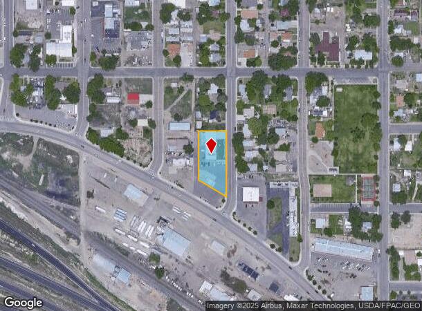
Property Record
221 Highway 6 And 50, Fruita, CO 81521

Current Lease Availabilities
NEARBY LISTINGS FOR SALE OR LEASE
Property Detail
221 Highway 6 And 50
2697-173-00-088
BEG A PT WHENCE NW COR NE4SW4 SEC 17 1N 2W BEARS N 45DEG W 56.56FT E 580FT S 260FT FOR BEG W 124FT S 75FT E 124FT N TO BEG & BEG 620FT E + 375FT S OF NW COR NE4SW4 SEC 17 1N 2W W 124FT S 89.8FT TO HWY ROW SELY ALG ROW 144.7FT N 164.1FT TO BEG & ALSO
Commercialnec
Mesa
X
Colorado
08077C0438F
88
2023
0.71 AC
2024
Colorado Northwest Area
001504
Other Market Areas
7,320 SF
Grand Junction, CO
DEMOGRAPHICS near 221 Highway 6 And 50
1 Mile
3 Mile
5 Mile
2024 Total Population
9,068
16,058
19,942
2029 Population
9,571
16,901
20,898
Pop Growth 2024-2029
+ 5.55%
+ 5.25%
+ 4.79%
Average Age
40
41
42
2024 Total Households
3,565
6,242
7,645
HH Growth 2024-2029
+ 5.53%
+ 5.24%
+ 4.83%
Median Household Inc
$57,322
$67,774
$73,149
Avg Household Size
2.50
2.60
2.60
2024 Avg HH Vehicles
2.00
2.00
2.00
Median Home Value
$334,081
$361,265
$390,346
Median Year Built
1997
1999
1998
Nearby Places
Map Layers
Map Styles
 Street
 Aerial
- Restaurants
- Banks
- Shops
- Fitness
- Groceries
PUBLIC TRANSPORTATION
AIRPORT
Grand Junction Regional
DRIVE
WALK
Distance
Grand Junction Regional
19 min
14.1 mi
Nearby Properties
Address
Land Use
TOTAL SIZE
Lot Size
Zoning
Address
Land Use
TOTAL SIZE
Lot Size
Zoning
74,301 SF
0.02 AC
Address
Land Use
TOTAL SIZE
Lot Size
Zoning
188,386 SF
39.06 AC
CSR
Address
Land Use
TOTAL SIZE
Lot Size
Zoning
97,809 SF
22.16 AC
Address
Land Use
TOTAL SIZE
Lot Size
Zoning
70,671 SF
12.63 AC
Address
Land Use
TOTAL SIZE
Lot Size
Zoning
57,933 SF
10 AC
CSR
Address
Land Use
TOTAL SIZE
Lot Size
Zoning
58,696 SF
8.37 AC
Address
Land Use
TOTAL SIZE
Lot Size
Zoning
60,000 SF
11.50 AC
Address
Land Use
TOTAL SIZE
Lot Size
Zoning
46,918 SF
1.08 AC
Address
Land Use
TOTAL SIZE
Lot Size
Zoning
70,981 SF
0.27 AC
Address
Land Use
TOTAL SIZE
Lot Size
Zoning
64,189 SF
5.47 AC
I-2
Address
Land Use
TOTAL SIZE
Lot Size
Zoning
50,790 SF
9,964.10 AC
TC
Address
Land Use
TOTAL SIZE
Lot Size
Zoning
40,562 SF
22.42 AC
LIRD
Address
Land Use
TOTAL SIZE
Lot Size
Zoning
62,420 SF
4.76 AC
LIRD
Address
Land Use
TOTAL SIZE
Lot Size
Zoning
226,543 SF
28.36 AC
Address
Land Use
TOTAL SIZE
Lot Size
Zoning
16,677 SF
6.75 AC
Address
Land Use
TOTAL SIZE
Lot Size
Zoning
27,000 SF
14.94 AC
GC
Address
Land Use
TOTAL SIZE
Lot Size
Zoning
22,712 SF
3.65 AC
CRS
Address
Land Use
TOTAL SIZE
Lot Size
Zoning
16,257 SF
0.66 AC
Address
Land Use
TOTAL SIZE
Lot Size
Zoning
39,496 SF
2.39 AC
Address
Land Use
TOTAL SIZE
Lot Size
Zoning
50,613 SF
5.07 AC
Address
Land Use
TOTAL SIZE
Lot Size
Zoning
31,236 SF
1.20 AC
TCDD
Address
Land Use
TOTAL SIZE
Lot Size
Zoning
23,065 SF
85.08 AC
Address
Land Use
TOTAL SIZE
Lot Size
Zoning
24,495 SF
2.03 AC
Address
Land Use
TOTAL SIZE
Lot Size
Zoning
21,846 SF
4.68 AC
TCDD
Address
Land Use
TOTAL SIZE
Lot Size
Zoning
21,368 SF
35.53 AC
LIRD
Address
Land Use
TOTAL SIZE
Lot Size
Zoning
8.53 AC
Address
Land Use
TOTAL SIZE
Lot Size
Zoning
8.53 AC
Address
Land Use
TOTAL SIZE
Lot Size
Zoning
19,370 SF
4.30 AC
Address
Land Use
TOTAL SIZE
Lot Size
Zoning
14,406 SF
1.77 AC
DCRD
Address
Land Use
TOTAL SIZE
Lot Size
Zoning
26,732 SF
4.75 AC
The World's #1 Commercial Real Estate Marketplace
Connect with us
© 2025 CoStar Group
The information above has been obtained from sources believed reliable. While we do not doubt its accuracy we have not verified it and make no guarantee, warranty or representation about it. It is your responsibility to independently confirm its accuracy and completeness. Any projections, opinions, assumptions, or estimates used are for example only and do not represent the current or future performance of the property. The value of this transaction to you depends on tax and other factors which should be evaluated by your tax, financial, and legal advisors. You and your advisors should conduct a careful, independent investigation of the property to determine to your satisfaction the suitability of the property for your needs.