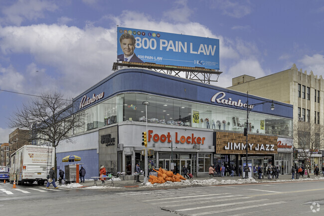
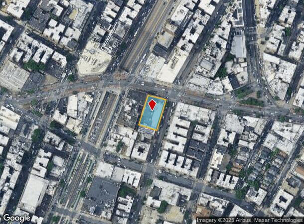
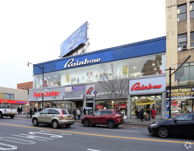
Property Record
222 E Fordham Rd, Bronx, NY 10458
Current Lease Availabilities
General Retail LEASE
$200.00 - $225.00 SF/YR
3,200 - 12,000 SF
NEARBY LISTINGS FOR SALE OR LEASE
Property Detail
222 E Fordham Rd
03153-0023
Bronx
Storebuilding
New York
X
23
3604970082F
0.46 AC
2024
Bronx
2025
Westchester/So Connecticut
039700
New York-Jersey City-White Plains, NY-NJ
37,734 SF
DEMOGRAPHICS near 222 E Fordham Rd
1 mile
3 mile
5 mile
2024 Total Population
224,685
1,164,153
1,946,290
2029 Population
211,345
1,082,285
1,812,331
Pop Growth 2024-2029
(5.94%)
(7.03%)
(6.88%)
Average Age
36
38
39
2024 Total Households
75,118
413,986
715,621
HH Growth 2024-2029
(6.66%)
(7.66%)
(7.35%)
Median Household Inc
$39,446
$43,948
$46,890
Avg Household Size
2.80
2.70
2.60
2024 Avg HH Vehicles
.00
.00
1.00
Median Home Value
$326,133
$512,035
$522,832
Median Year Built
1947
1949
1952
Nearby Places
Map Layers
Map Styles
 Street
 Aerial
Transit
 Traffic
 Biking
Places
Listings with unknown addresses are not visible on the map
- Restaurants
- Banks
- Shops
- Fitness
- Groceries
PUBLIC TRANSPORTATION
TRANSIT/SUBWAY
Fordham Road (B,D Line) (B - New York MTA Subway (The Subway), D - New York MTA Subway (The Subway))
Drive
Walk
Distance
Fordham Road (B,D Line) (B - New York MTA Subway (The Subway), D - New York MTA Subway (The Subway))
3 min
4 min
0.2 mi
Fordham Road (4 Line) (4 - New York MTA Subway (The Subway))
Drive
Walk
Distance
Fordham Road (4 Line) (4 - New York MTA Subway (The Subway))
4 min
7 min
0.3 mi
Kingsbridge Road (B,D Line) (B - New York MTA Subway (The Subway), D - New York MTA Subway (The Subway))
Drive
Walk
Distance
Kingsbridge Road (B,D Line) (B - New York MTA Subway (The Subway), D - New York MTA Subway (The Subway))
4 min
8 min
0.4 mi
182-183 Streets (B - New York MTA Subway (The Subway), D - New York MTA Subway (The Subway))
Drive
Walk
Distance
182-183 Streets (B - New York MTA Subway (The Subway), D - New York MTA Subway (The Subway))
3 min
11 min
0.5 mi
Kingsbridge Road (4 Line) (4 - New York MTA Subway (The Subway))
Drive
Walk
Distance
Kingsbridge Road (4 Line) (4 - New York MTA Subway (The Subway))
4 min
11 min
0.5 mi
COMMUTER RAIL
Fordham Station (Harlem Line - Metro-North Commuter Railroad Company (Metro-North), New Haven Line - Metro-North Commuter Railroad Company (Metro-North))
Drive
Walk
Distance
Fordham Station (Harlem Line - Metro-North Commuter Railroad Company (Metro-North), New Haven Line - Metro-North Commuter Railroad Company (Metro-North))
2 min
8 min
0.3 mi
Botanical Garden Station (Harlem Line - Metro-North Commuter Railroad Company (Metro-North))
Drive
Walk
Distance
Botanical Garden Station (Harlem Line - Metro-North Commuter Railroad Company (Metro-North))
6 min
19 min
1.0 mi
AIRPORT
LaGuardia
Drive
Walk
Distance
LaGuardia
20 min
11.8 mi
John F Kennedy International
Drive
Walk
Distance
John F Kennedy International
31 min
20.1 mi
Newark Liberty International
Drive
Walk
Distance
Newark Liberty International
30 min
23.4 mi
Nearby Properties
Address
Land Use
TOTAL SIZE
Lot Size
Zoning
Address
Land Use
TOTAL SIZE
Lot Size
Zoning
3,693,539 SF
8.37 AC
R8
Address
Land Use
TOTAL SIZE
Lot Size
Zoning
1,299,700 SF
29.82 AC
R6
Address
Land Use
TOTAL SIZE
Lot Size
Zoning
1,743,584 SF
77.87 AC
R6
Address
Land Use
TOTAL SIZE
Lot Size
Zoning
1,427,393 SF
39.94 AC
R4
Address
Land Use
TOTAL SIZE
Lot Size
Zoning
1,651,267 SF
1.23 AC
R8
Address
Land Use
TOTAL SIZE
Lot Size
Zoning
481,172 SF
205.58 AC
PARK
Address
Land Use
TOTAL SIZE
Lot Size
Zoning
895,256 SF
8.32 AC
R7-1
Address
Land Use
TOTAL SIZE
Lot Size
Zoning
0.36 AC
R8
Address
Land Use
TOTAL SIZE
Lot Size
Zoning
891,040 SF
5.63 AC
R8
Address
Land Use
TOTAL SIZE
Lot Size
Zoning
23.12 AC
PARK
Address
Land Use
TOTAL SIZE
Lot Size
Zoning
1,237,424 SF
21.25 AC
R6
Address
Land Use
TOTAL SIZE
Lot Size
Zoning
204,200 SF
1.68 AC
R7-1
Address
Land Use
TOTAL SIZE
Lot Size
Zoning
807,327 SF
0.60 AC
R8
Address
Land Use
TOTAL SIZE
Lot Size
Zoning
667,405 SF
5.51 AC
R6
Address
Land Use
TOTAL SIZE
Lot Size
Zoning
39 AC
P1
Address
Land Use
TOTAL SIZE
Lot Size
Zoning
390,750 SF
265 AC
PARK
Address
Land Use
TOTAL SIZE
Lot Size
Zoning
617,567 SF
3.19 AC
R7-1
Address
Land Use
TOTAL SIZE
Lot Size
Zoning
890,134 SF
8.79 AC
R7-2
Address
Land Use
TOTAL SIZE
Lot Size
Zoning
317,485 SF
1.57 AC
R8
Address
Land Use
TOTAL SIZE
Lot Size
Zoning
43.65 AC
PARK
Address
Land Use
TOTAL SIZE
Lot Size
Zoning
890,134 SF
8.79 AC
R7-2
Address
Land Use
TOTAL SIZE
Lot Size
Zoning
890,134 SF
8.79 AC
R7-2
Address
Land Use
TOTAL SIZE
Lot Size
Zoning
890,134 SF
8.79 AC
R7-2
Address
Land Use
TOTAL SIZE
Lot Size
Zoning
890,134 SF
0.54 AC
R7-2
Address
Land Use
TOTAL SIZE
Lot Size
Zoning
890,134 SF
8.79 AC
R7-2
Address
Land Use
TOTAL SIZE
Lot Size
Zoning
890,134 SF
0.54 AC
R7-2
Address
Land Use
TOTAL SIZE
Lot Size
Zoning
890,134 SF
8.79 AC
R7-2
Address
Land Use
TOTAL SIZE
Lot Size
Zoning
890,134 SF
8.79 AC
R7-2
Address
Land Use
TOTAL SIZE
Lot Size
Zoning
890,134 SF
0.54 AC
R7-2
Address
Land Use
TOTAL SIZE
Lot Size
Zoning
890,134 SF
8.79 AC
R7-2
The World's #1 Commercial Real Estate Marketplace
Connect with us
© 2026 CoStar Group
The information above has been obtained from sources believed reliable. While we do not doubt its accuracy we have not verified it and make no guarantee, warranty or representation about it. It is your responsibility to independently confirm its accuracy and completeness. Any projections, opinions, assumptions, or estimates used are for example only and do not represent the current or future performance of the property. The value of this transaction to you depends on tax and other factors which should be evaluated by your tax, financial, and legal advisors. You and your advisors should conduct a careful, independent investigation of the property to determine to your satisfaction the suitability of the property for your needs.