Property Record
2226 Lancaster Ave, Monroe, NC 28112
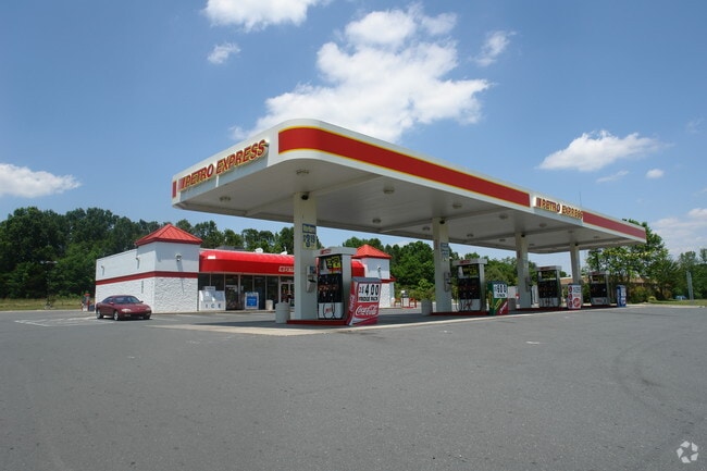

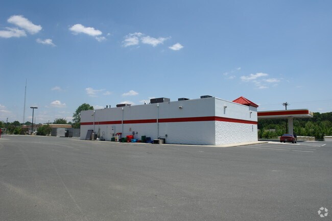

Property Detail
2226 Lancaster Ave
09-327-001-N
2226 LANCASTER HWY
Conveniencestore
Union
GB MONROE
North Carolina
B and X Area of moderate flood hazard, usually the area between the limits of the 100-year and 500-year floods.
2.19 AC
2025
Union County
2025
Charlotte
020501
Charlotte-Concord-Gastonia, NC-SC
3,040 SF
NEARBY LISTINGS FOR SALE OR LEASE
DEMOGRAPHICS near 2226 Lancaster Ave
1 mile
3 mile
5 mile
2025 Total Population
2,533
21,064
47,769
2030 Population
2,797
23,060
52,429
Pop Growth 2025-2030
+ 10.42%
+ 9.48%
+ 9.76%
Average Age
40
39
39
2025 Total Households
903
7,488
16,982
HH Growth 2025-2030
+ 10.41%
+ 9.55%
+ 9.83%
Median Household Inc
$84,970
$66,164
$71,059
Avg Household Size
2.70
2.70
2.70
2025 Avg HH Vehicles
2.00
2.00
2.00
Median Home Value
$280,081
$306,471
$340,560
Median Year Built
1994
1987
1991
Nearby Places
Map Layers
Map Styles
 Street
 Aerial
Layers
 Traffic
 Biking
Places
Listings with unknown addresses are not visible on the map
- Restaurants
- Banks
- Shops
- Fitness
- Groceries
PUBLIC TRANSPORTATION
AIRPORT
Charlotte/Douglas International
Drive
Walk
Distance
Charlotte/Douglas International
52 min
34.2 mi
Concord-Padgett Regional
Drive
Walk
Distance
Concord-Padgett Regional
52 min
38.5 mi
Nearby Properties
Address
Land Use
TOTAL SIZE
Lot Size
Zoning
Address
Land Use
TOTAL SIZE
Lot Size
Zoning
99,235 SF
1.92 AC
CBD MONROE
Address
Land Use
TOTAL SIZE
Lot Size
Zoning
57,664 SF
45.15 AC
R-20 MONRO
Address
Land Use
TOTAL SIZE
Lot Size
Zoning
71,831 SF
67.94 AC
CD MONROE
Address
Land Use
TOTAL SIZE
Lot Size
Zoning
97,083 SF
32.30 AC
R-40 MONRO
Address
Land Use
TOTAL SIZE
Lot Size
Zoning
79,493 SF
18.97 AC
CD MONROE
Address
Land Use
TOTAL SIZE
Lot Size
Zoning
5,376 SF
11.99 AC
R-MF MONRO
Address
Land Use
TOTAL SIZE
Lot Size
Zoning
5.89 AC
G-I MONROE
Address
Land Use
TOTAL SIZE
Lot Size
Zoning
6,672 SF
5.08 AC
OT MONROE
Address
Land Use
TOTAL SIZE
Lot Size
Zoning
101,035 SF
26.11 AC
G-I MONROE
Address
Land Use
TOTAL SIZE
Lot Size
Zoning
9,072 SF
15.23 AC
R-MF MONRO
Address
Land Use
TOTAL SIZE
Lot Size
Zoning
2,016 SF
6.20 AC
R-MF MONRO
Address
Land Use
TOTAL SIZE
Lot Size
Zoning
65,122 SF
5.26 AC
R-10 MONRO
Address
Land Use
TOTAL SIZE
Lot Size
Zoning
41,820 SF
6.23 AC
G-I MONROE
Address
Land Use
TOTAL SIZE
Lot Size
Zoning
17 AC
R-20 MONRO
Address
Land Use
TOTAL SIZE
Lot Size
Zoning
33,699 SF
2.55 AC
OT MONROE
Address
Land Use
TOTAL SIZE
Lot Size
Zoning
18,200 SF
0.76 AC
CBD MONROE
Address
Land Use
TOTAL SIZE
Lot Size
Zoning
20,700 SF
4.76 AC
CBD MONROE
Address
Land Use
TOTAL SIZE
Lot Size
Zoning
4.42 AC
GB MONROE
Address
Land Use
TOTAL SIZE
Lot Size
Zoning
97,344 SF
31.11 AC
R-10 MONRO
Address
Land Use
TOTAL SIZE
Lot Size
Zoning
21,576 SF
1.37 AC
GB MONROE
Address
Land Use
TOTAL SIZE
Lot Size
Zoning
155,110 SF
21.75 AC
G-I MONROE
Address
Land Use
TOTAL SIZE
Lot Size
Zoning
36,821 SF
1.75 AC
OT MONROE
Address
Land Use
TOTAL SIZE
Lot Size
Zoning
2,440 SF
7.30 AC
R-MF MONRO
Address
Land Use
TOTAL SIZE
Lot Size
Zoning
14,100 SF
8.52 AC
R-10 MONRO
Address
Land Use
TOTAL SIZE
Lot Size
Zoning
19,730 SF
2.78 AC
OT MONROE
Address
Land Use
TOTAL SIZE
Lot Size
Zoning
8,064 SF
3.52 AC
R-MF MONRO
Address
Land Use
TOTAL SIZE
Lot Size
Zoning
35,008 SF
1.37 AC
OT MONROE
Address
Land Use
TOTAL SIZE
Lot Size
Zoning
7,612 SF
0.34 AC
CBD MONROE
Address
Land Use
TOTAL SIZE
Lot Size
Zoning
54,419 SF
8.18 AC
R-10 MONRO
Address
Land Use
TOTAL SIZE
Lot Size
Zoning
3,832 SF
4.74 AC
R-MF MONRO
The World's #1 Commercial Real Estate Marketplace
Connect with us
© 2026 CoStar Group
The information above has been obtained from sources believed reliable. While we do not doubt its accuracy we have not verified it and make no guarantee, warranty or representation about it. It is your responsibility to independently confirm its accuracy and completeness. Any projections, opinions, assumptions, or estimates used are for example only and do not represent the current or future performance of the property. The value of this transaction to you depends on tax and other factors which should be evaluated by your tax, financial, and legal advisors. You and your advisors should conduct a careful, independent investigation of the property to determine to your satisfaction the suitability of the property for your needs.