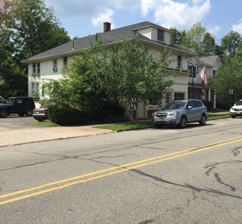
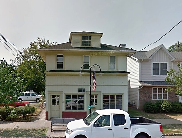
Property Record
224 Main Ave, Stirling, NJ 07980

Property Detail
224 Main Ave
Newark, NJ
MORRIS
30-11606-0000-00017
New Jersey
Medicalbuilding
17
2024
0.21 AC
2025
Morristown Region
044102
Northern New Jersey
2,808 SF
NEARBY LISTINGS FOR SALE OR LEASE
DEMOGRAPHICS near 224 Main Ave
1 mile
3 mile
5 mile
2025 Total Population
3,368
26,150
96,200
2030 Population
3,440
27,309
99,958
Pop Growth 2025-2030
+ 2.14%
+ 4.43%
+ 3.91%
Average Age
42
43
42
2025 Total Households
1,221
9,437
34,087
HH Growth 2025-2030
+ 2.13%
+ 4.55%
+ 4.05%
Median Household Inc
$152,927
$173,121
$158,069
Avg Household Size
2.70
2.70
2.80
2025 Avg HH Vehicles
2.00
2.00
2.00
Median Home Value
$737,931
$766,549
$753,980
Median Year Built
1961
1979
1971
Nearby Places
Map Layers
Map Styles
 Street
 Aerial
Layers
 Traffic
 Biking
Places
Listings with unknown addresses are not visible on the map
- Restaurants
- Banks
- Shops
- Fitness
- Groceries
PUBLIC TRANSPORTATION
COMMUTER RAIL
Stirling (Morris & Essex Gladstone Branch - NJ Transit Commuter Rail (NJ Transit))
Drive
Walk
Distance
Stirling (Morris & Essex Gladstone Branch - NJ Transit Commuter Rail (NJ Transit))
1 min
3 min
0.1 mi
Millington (Morris & Essex Gladstone Branch - NJ Transit Commuter Rail (NJ Transit))
Drive
Walk
Distance
Millington (Morris & Essex Gladstone Branch - NJ Transit Commuter Rail (NJ Transit))
6 min
2.1 mi
AIRPORT
Newark Liberty International
Drive
Walk
Distance
Newark Liberty International
32 min
23.0 mi
LaGuardia
Drive
Walk
Distance
LaGuardia
68 min
42.3 mi
Trenton Mercer
Drive
Walk
Distance
Trenton Mercer
73 min
43.2 mi
Freight Ports
Maher Terminal
Drive
Walk
Distance
Maher Terminal
37 min
24.1 mi
Nearby Properties
Address
Land Use
TOTAL SIZE
Lot Size
Zoning
Address
Land Use
TOTAL SIZE
Lot Size
Zoning
52.31 AC
OR
Address
Land Use
TOTAL SIZE
Lot Size
Zoning
206,077 SF
22.03 AC
B5
Address
Land Use
TOTAL SIZE
Lot Size
Zoning
34.27 AC
R65
Address
Land Use
TOTAL SIZE
Lot Size
Zoning
67.22 AC
R65
Address
Land Use
TOTAL SIZE
Lot Size
Zoning
839.97 AC
P1
Address
Land Use
TOTAL SIZE
Lot Size
Zoning
23.93 AC
B2
Address
Land Use
TOTAL SIZE
Lot Size
Zoning
18.66 AC
CR
Address
Land Use
TOTAL SIZE
Lot Size
Zoning
8.64 AC
AH-4
Address
Land Use
TOTAL SIZE
Lot Size
Zoning
68,160 SF
11.66 AC
R6
Address
Land Use
TOTAL SIZE
Lot Size
Zoning
1,096 SF
15.12 AC
R5
Address
Land Use
TOTAL SIZE
Lot Size
Zoning
8.09 AC
B3
Address
Land Use
TOTAL SIZE
Lot Size
Zoning
40.36 AC
OR
Address
Land Use
TOTAL SIZE
Lot Size
Zoning
30.84 AC
OR
Address
Land Use
TOTAL SIZE
Lot Size
Zoning
61,059 SF
9.10 AC
R6
Address
Land Use
TOTAL SIZE
Lot Size
Zoning
40.73 AC
OR
Address
Land Use
TOTAL SIZE
Lot Size
Zoning
1,950 SF
10.56 AC
CR
Address
Land Use
TOTAL SIZE
Lot Size
Zoning
15.73 AC
GI
Address
Land Use
TOTAL SIZE
Lot Size
Zoning
22.61 AC
GI
Address
Land Use
TOTAL SIZE
Lot Size
Zoning
Address
Land Use
TOTAL SIZE
Lot Size
Zoning
1.59 AC
GI
Address
Land Use
TOTAL SIZE
Lot Size
Zoning
2.71 AC
CR
Address
Land Use
TOTAL SIZE
Lot Size
Zoning
5,120 SF
179.76 AC
M-1
Address
Land Use
TOTAL SIZE
Lot Size
Zoning
1.28 AC
GI
Address
Land Use
TOTAL SIZE
Lot Size
Zoning
6.92 AC
B2
Address
Land Use
TOTAL SIZE
Lot Size
Zoning
19.20 AC
GI
Address
Land Use
TOTAL SIZE
Lot Size
Zoning
7.46 AC
BR80
Address
Land Use
TOTAL SIZE
Lot Size
Zoning
23.61 AC
R65
Address
Land Use
TOTAL SIZE
Lot Size
Zoning
30.26 AC
C
Address
Land Use
TOTAL SIZE
Lot Size
Zoning
7.94 AC
GI
Address
Land Use
TOTAL SIZE
Lot Size
Zoning
21.30 AC
OL
The World's #1 Commercial Real Estate Marketplace
Connect with us
© 2026 CoStar Group
The information above has been obtained from sources believed reliable. While we do not doubt its accuracy we have not verified it and make no guarantee, warranty or representation about it. It is your responsibility to independently confirm its accuracy and completeness. Any projections, opinions, assumptions, or estimates used are for example only and do not represent the current or future performance of the property. The value of this transaction to you depends on tax and other factors which should be evaluated by your tax, financial, and legal advisors. You and your advisors should conduct a careful, independent investigation of the property to determine to your satisfaction the suitability of the property for your needs.