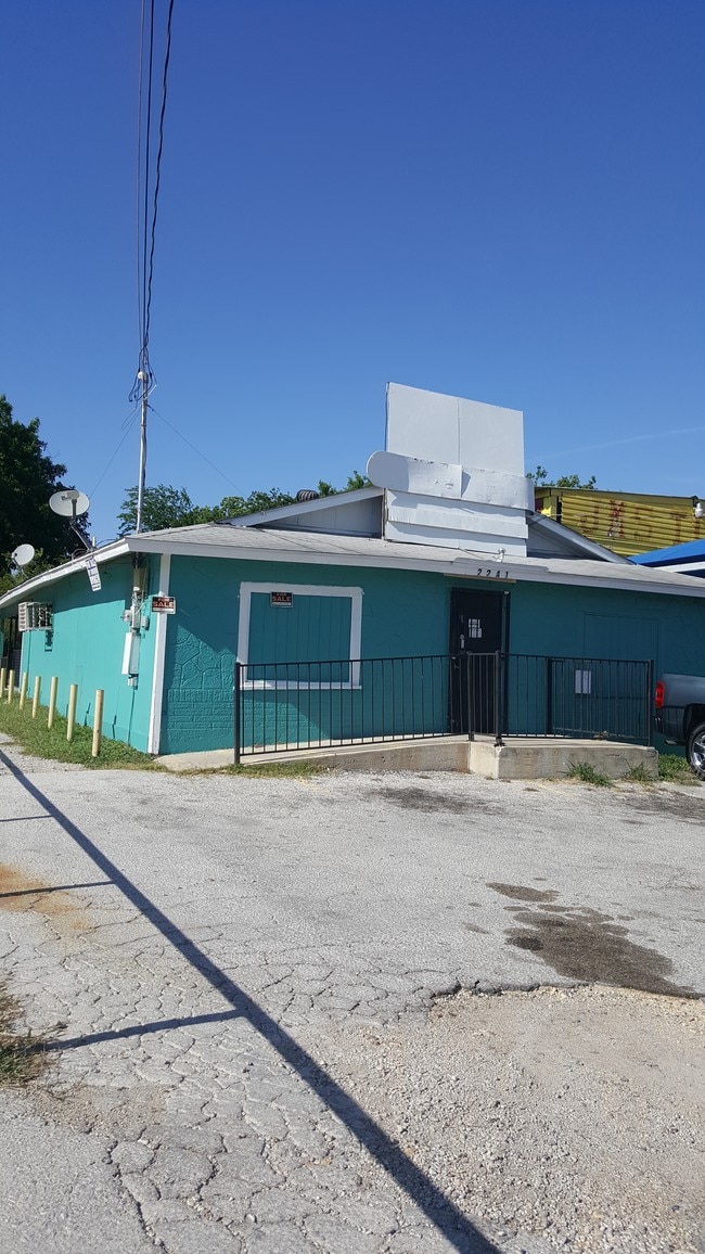
Property Record
2241 Cincinnati Ave, San Antonio, TX 78228

NEARBY LISTINGS FOR SALE OR LEASE
Property Detail
2241 Cincinnati Ave
San Antonio-New Braunfels, TX
Conv A/S Code
08334-019-0180
NCB 8334 BLK 19 LOT W IRR 48.33 FT OF 18
Bartavern
Bexar
X
Texas
48029C0383H
18
2024
0.15 AC
2025
Northwest
170600
San Antonio
2,000 SF
DEMOGRAPHICS near 2241 Cincinnati Ave
1 Mile
3 Mile
5 Mile
2024 Total Population
15,572
159,752
360,465
2029 Population
16,416
168,967
383,033
Pop Growth 2024-2029
+ 5.42%
+ 5.77%
+ 6.26%
Average Age
39
38
38
2024 Total Households
5,472
55,939
137,999
HH Growth 2024-2029
+ 5.54%
+ 5.98%
+ 6.69%
Median Household Inc
$47,346
$37,276
$41,819
Avg Household Size
2.80
2.70
2.50
2024 Avg HH Vehicles
2.00
2.00
2.00
Median Home Value
$131,486
$131,084
$153,195
Median Year Built
1955
1958
1966
Nearby Places
Map Layers
Map Styles
 Street
 Aerial
- Restaurants
- Banks
- Shops
- Fitness
- Groceries
PUBLIC TRANSPORTATION
COMMUTER RAIL
San Antonio Amtrak Station (Sunset Limited - Amtrak, Texas Eagle - Amtrak)
DRIVE
WALK
Distance
San Antonio Amtrak Station (Sunset Limited - Amtrak, Texas Eagle - Amtrak)
10 min
5.6 mi
AIRPORT
San Antonio International
DRIVE
WALK
Distance
San Antonio International
15 min
9.9 mi
Freight Ports
Calhoun Port
DRIVE
WALK
Distance
Calhoun Port
187 min
153.0 mi
SALE & LEASE HISTORY
LISTING DATE
SALE/LEASE

Sep 24, 2016
For Sale
Sep 18, 2023
For Sale
Oct 17, 2022
For Sale
Oct 10, 2017
For Lease
Jun 21, 2023
For Sale
Jun 10, 2020
For Sale
Feb 03, 2022
For Sale
Apr 21, 2017
For Lease
Nearby Properties
Address
Land Use
TOTAL SIZE
Lot Size
Zoning
Address
Land Use
TOTAL SIZE
Lot Size
Zoning
50.69 AC
Address
Land Use
TOTAL SIZE
Lot Size
Zoning
122,292 SF
12.83 AC
Address
Land Use
TOTAL SIZE
Lot Size
Zoning
138,674 SF
11.14 AC
Address
Land Use
TOTAL SIZE
Lot Size
Zoning
245,371 SF
20.50 AC
Address
Land Use
TOTAL SIZE
Lot Size
Zoning
Address
Land Use
TOTAL SIZE
Lot Size
Zoning
98,208 SF
0.94 AC
Address
Land Use
TOTAL SIZE
Lot Size
Zoning
27,517 SF
27.66 AC
Address
Land Use
TOTAL SIZE
Lot Size
Zoning
Address
Land Use
TOTAL SIZE
Lot Size
Zoning
223,148 SF
19.15 AC
Address
Land Use
TOTAL SIZE
Lot Size
Zoning
99,538 SF
11.89 AC
Address
Land Use
TOTAL SIZE
Lot Size
Zoning
102,456 SF
7.35 AC
Address
Land Use
TOTAL SIZE
Lot Size
Zoning
173,363 SF
10.29 AC
Address
Land Use
TOTAL SIZE
Lot Size
Zoning
315,630 SF
10.19 AC
Address
Land Use
TOTAL SIZE
Lot Size
Zoning
841,948 SF
27.14 AC
Address
Land Use
TOTAL SIZE
Lot Size
Zoning
125,776 SF
6.98 AC
Address
Land Use
TOTAL SIZE
Lot Size
Zoning
104,983 SF
2.86 AC
Address
Land Use
TOTAL SIZE
Lot Size
Zoning
148,206 SF
7.69 AC
Address
Land Use
TOTAL SIZE
Lot Size
Zoning
179,276 SF
20.19 AC
Address
Land Use
TOTAL SIZE
Lot Size
Zoning
143,212 SF
14.85 AC
Address
Land Use
TOTAL SIZE
Lot Size
Zoning
245,574 SF
19.65 AC
Address
Land Use
TOTAL SIZE
Lot Size
Zoning
133,892 SF
7.41 AC
Address
Land Use
TOTAL SIZE
Lot Size
Zoning
155,130 SF
13.89 AC
Address
Land Use
TOTAL SIZE
Lot Size
Zoning
122,778 SF
11.27 AC
Address
Land Use
TOTAL SIZE
Lot Size
Zoning
150,500 SF
5.12 AC
Address
Land Use
TOTAL SIZE
Lot Size
Zoning
198,545 SF
9.36 AC
Address
Land Use
TOTAL SIZE
Lot Size
Zoning
195,217 SF
8.80 AC
Address
Land Use
TOTAL SIZE
Lot Size
Zoning
141,826 SF
7.30 AC
Address
Land Use
TOTAL SIZE
Lot Size
Zoning
117,770 SF
6.76 AC
Address
Land Use
TOTAL SIZE
Lot Size
Zoning
129,800 SF
5.60 AC
Address
Land Use
TOTAL SIZE
Lot Size
Zoning
177,382 SF
11.47 AC
The World's #1 Commercial Real Estate Marketplace
Connect with us
© 2025 CoStar Group
The information above has been obtained from sources believed reliable. While we do not doubt its accuracy we have not verified it and make no guarantee, warranty or representation about it. It is your responsibility to independently confirm its accuracy and completeness. Any projections, opinions, assumptions, or estimates used are for example only and do not represent the current or future performance of the property. The value of this transaction to you depends on tax and other factors which should be evaluated by your tax, financial, and legal advisors. You and your advisors should conduct a careful, independent investigation of the property to determine to your satisfaction the suitability of the property for your needs.