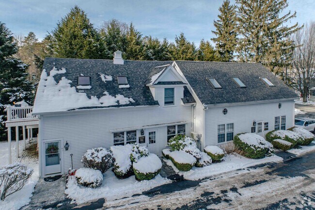
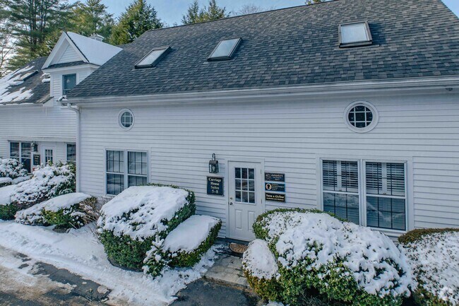
Property Record
225 Main St, Wenham, MA 01984

Property Detail
225 Main St
Boston-Cambridge-Newton, MA-NH
Essex
WENH-000014-000000-000006
Massachusetts
Commercialofficeresidentialmixeduse
6
B and X Area of moderate flood hazard, usually the area between the limits of the 100-year and 500-year floods.
1.12 AC
2025
Essex/Gloucester
2025
Boston
216100
NEARBY LISTINGS FOR SALE OR LEASE
DEMOGRAPHICS near 225 Main St
1 mile
3 mile
5 mile
2025 Total Population
4,958
25,894
92,780
2030 Population
5,137
26,761
95,475
Pop Growth 2025-2030
+ 3.61%
+ 3.35%
+ 2.90%
Average Age
40
42
42
2025 Total Households
1,642
9,246
35,544
HH Growth 2025-2030
+ 3.65%
+ 3.37%
+ 2.89%
Median Household Inc
$145,546
$126,555
$116,304
Avg Household Size
2.70
2.60
2.40
2025 Avg HH Vehicles
2.00
2.00
2.00
Median Home Value
$765,691
$770,340
$736,523
Median Year Built
1954
1963
1961
Nearby Places
Map Layers
Map Styles
 Street
 Aerial
Layers
 Traffic
 Biking
Places
Listings with unknown addresses are not visible on the map
- Restaurants
- Banks
- Shops
- Fitness
- Groceries
PUBLIC TRANSPORTATION
TRANSIT/SUBWAY
Hamilton/Wenham (Newburyport/Rockport Line - Massachusetts Bay Transportation Authority Commuter Rail (Purple Line))
Drive
Walk
Distance
Hamilton/Wenham (Newburyport/Rockport Line - Massachusetts Bay Transportation Authority Commuter Rail (Purple Line))
2 min
5 min
0.3 mi
COMMUTER RAIL
Hamilton/Wenham (Newburyport/Rockport Line - Massachusetts Bay Transportation Authority Commuter Rail (Purple Line))
Drive
Walk
Distance
Hamilton/Wenham (Newburyport/Rockport Line - Massachusetts Bay Transportation Authority Commuter Rail (Purple Line))
2 min
5 min
0.3 mi
North Beverly (Newburyport/Rockport Line - Massachusetts Bay Transportation Authority Commuter Rail (Purple Line))
Drive
Walk
Distance
North Beverly (Newburyport/Rockport Line - Massachusetts Bay Transportation Authority Commuter Rail (Purple Line))
6 min
2.3 mi
AIRPORT
General Edward Lawrence Logan International
Drive
Walk
Distance
General Edward Lawrence Logan International
40 min
21.7 mi
Portsmouth International at Pease
Drive
Walk
Distance
Portsmouth International at Pease
58 min
40.3 mi
Manchester Boston Regional
Drive
Walk
Distance
Manchester Boston Regional
80 min
46.3 mi
SALE & LEASE HISTORY
LISTING DATE
SALE/LEASE

May 07, 2024
For Lease
Apr 19, 2017
For Lease
Nearby Properties
Address
Land Use
TOTAL SIZE
Lot Size
Zoning
Address
Land Use
TOTAL SIZE
Lot Size
Zoning
228,295 SF
12.50 AC
RMD
Address
Land Use
TOTAL SIZE
Lot Size
Zoning
172.50 AC
R3
Address
Land Use
TOTAL SIZE
Lot Size
Zoning
64,451 SF
102.50 AC
R1A
Address
Land Use
TOTAL SIZE
Lot Size
Zoning
212,956 SF
44.90 AC
R1B
Address
Land Use
TOTAL SIZE
Lot Size
Zoning
207,237 SF
16.73 AC
RMD
Address
Land Use
TOTAL SIZE
Lot Size
Zoning
195,527 SF
16.60 AC
CG
Address
Land Use
TOTAL SIZE
Lot Size
Zoning
358,662 SF
36.98 AC
IR
Address
Land Use
TOTAL SIZE
Lot Size
Zoning
162,182 SF
9.53 AC
IR
Address
Land Use
TOTAL SIZE
Lot Size
Zoning
46,504 SF
48 AC
RA
Address
Land Use
TOTAL SIZE
Lot Size
Zoning
37,553 SF
238.29 AC
IR
Address
Land Use
TOTAL SIZE
Lot Size
Zoning
123,171 SF
9.09 AC
R10
Address
Land Use
TOTAL SIZE
Lot Size
Zoning
207,095 SF
IR
Address
Land Use
TOTAL SIZE
Lot Size
Zoning
150,183 SF
38.84 AC
IR
Address
Land Use
TOTAL SIZE
Lot Size
Zoning
122,105 SF
12.96 AC
R10
Address
Land Use
TOTAL SIZE
Lot Size
Zoning
328.40 AC
R1A
Address
Land Use
TOTAL SIZE
Lot Size
Zoning
79,964 SF
7.78 AC
R15
Address
Land Use
TOTAL SIZE
Lot Size
Zoning
68,740 SF
6.50 AC
IR
Address
Land Use
TOTAL SIZE
Lot Size
Zoning
156,675 SF
IR
Address
Land Use
TOTAL SIZE
Lot Size
Zoning
57,157 SF
7.80 AC
Address
Land Use
TOTAL SIZE
Lot Size
Zoning
93,708 SF
9.05 AC
IR
Address
Land Use
TOTAL SIZE
Lot Size
Zoning
98,700 SF
10.55 AC
IR
Address
Land Use
TOTAL SIZE
Lot Size
Zoning
97,396 SF
IR
Address
Land Use
TOTAL SIZE
Lot Size
Zoning
87,373 SF
7.02 AC
I1
Address
Land Use
TOTAL SIZE
Lot Size
Zoning
101,209 SF
8.79 AC
I2
Address
Land Use
TOTAL SIZE
Lot Size
Zoning
80,154 SF
5.85 AC
IR
Address
Land Use
TOTAL SIZE
Lot Size
Zoning
2,176 SF
548.70 AC
RA
Address
Land Use
TOTAL SIZE
Lot Size
Zoning
2,705 SF
24.60 AC
Address
Land Use
TOTAL SIZE
Lot Size
Zoning
142,596 SF
10.93 AC
IR
Address
Land Use
TOTAL SIZE
Lot Size
Zoning
127,674 SF
14.04 AC
IR
Address
Land Use
TOTAL SIZE
Lot Size
Zoning
43.68 AC
The World's #1 Commercial Real Estate Marketplace
Connect with us
© 2026 CoStar Group
The information above has been obtained from sources believed reliable. While we do not doubt its accuracy we have not verified it and make no guarantee, warranty or representation about it. It is your responsibility to independently confirm its accuracy and completeness. Any projections, opinions, assumptions, or estimates used are for example only and do not represent the current or future performance of the property. The value of this transaction to you depends on tax and other factors which should be evaluated by your tax, financial, and legal advisors. You and your advisors should conduct a careful, independent investigation of the property to determine to your satisfaction the suitability of the property for your needs.