Property Record
2251 W Devon Ave, Chicago, IL 60659
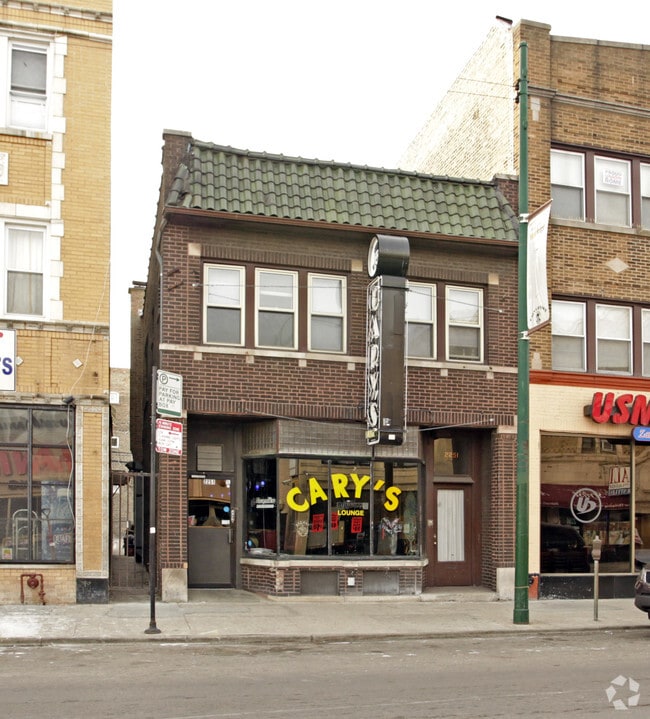

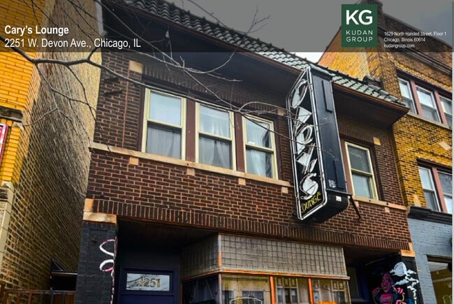
This Property Is For Sale
Property Detail
2251 W Devon Ave
14-06-102-003-0000
Cook
Miscresidentialimprovement
Illinois
B3-2
6
B and X Area of moderate flood hazard, usually the area between the limits of the 100-year and 500-year floods.
0.07 AC
2023
Northwest City
2025
Chicago
020901
Chicago-Naperville-Elgin, IL-IN
2,698 SF
NEARBY LISTINGS FOR SALE OR LEASE
DEMOGRAPHICS near 2251 W Devon Ave
1 mile
3 mile
5 mile
2025 Total Population
66,298
399,138
811,059
2030 Population
66,175
399,439
808,596
Pop Growth 2025-2030
(0.19%)
+ 0.08%
(0.30%)
Average Age
38
40
39
2025 Total Households
23,743
172,942
352,378
HH Growth 2025-2030
(0.45%)
(0.11%)
(0.42%)
Median Household Inc
$64,725
$74,757
$87,062
Avg Household Size
2.60
2.20
2.20
2025 Avg HH Vehicles
1.00
1.00
1.00
Median Home Value
$330,424
$371,953
$420,518
Median Year Built
1948
1948
1949
Nearby Places
Map Layers
Map Styles
 Street
 Aerial
Transit
 Traffic
 Biking
Places
Listings with unknown addresses are not visible on the map
- Restaurants
- Banks
- Shops
- Fitness
- Groceries
PUBLIC TRANSPORTATION
COMMUTER RAIL
Drive
Walk
Distance
2 min
20 min
1.0 mi
Rogers Park Station (Union Pacific North Line - Northeast Illinois Regional Commuter Railroad (Metra))
Drive
Walk
Distance
Rogers Park Station (Union Pacific North Line - Northeast Illinois Regional Commuter Railroad (Metra))
4 min
1.8 mi
AIRPORT
Chicago O'Hare International
Drive
Walk
Distance
Chicago O'Hare International
24 min
13.0 mi
Chicago Midway International
Drive
Walk
Distance
Chicago Midway International
33 min
17.2 mi
Nearby Properties
Address
Land Use
TOTAL SIZE
Lot Size
Zoning
Address
Land Use
TOTAL SIZE
Lot Size
Zoning
0.63 AC
PD 1372
Address
Land Use
TOTAL SIZE
Lot Size
Zoning
Address
Land Use
TOTAL SIZE
Lot Size
Zoning
892,012 SF
37.29 AC
Address
Land Use
TOTAL SIZE
Lot Size
Zoning
Address
Land Use
TOTAL SIZE
Lot Size
Zoning
305,592 SF
27.35 AC
Address
Land Use
TOTAL SIZE
Lot Size
Zoning
301,100 SF
2.20 AC
PD 37
Address
Land Use
TOTAL SIZE
Lot Size
Zoning
1 AC
RS-3
Address
Land Use
TOTAL SIZE
Lot Size
Zoning
82,139 SF
4.88 AC
Address
Land Use
TOTAL SIZE
Lot Size
Zoning
21.56 AC
RS-2
Address
Land Use
TOTAL SIZE
Lot Size
Zoning
PD 184
Address
Land Use
TOTAL SIZE
Lot Size
Zoning
147,835 SF
1.03 AC
PD 37
Address
Land Use
TOTAL SIZE
Lot Size
Zoning
170,538 SF
0.76 AC
PD 112
Address
Land Use
TOTAL SIZE
Lot Size
Zoning
71,400 SF
0.95 AC
RT-4,B3-2
Address
Land Use
TOTAL SIZE
Lot Size
Zoning
201,600 SF
1.93 AC
PD 92
Address
Land Use
TOTAL SIZE
Lot Size
Zoning
2.25 AC
PD 612
Address
Land Use
TOTAL SIZE
Lot Size
Zoning
139.71 AC
PD 184
Address
Land Use
TOTAL SIZE
Lot Size
Zoning
63,700 SF
7.42 AC
PD 796
Address
Land Use
TOTAL SIZE
Lot Size
Zoning
226,345 SF
3.71 AC
PD 1203
Address
Land Use
TOTAL SIZE
Lot Size
Zoning
197,785 SF
4.03 AC
PD 943
Address
Land Use
TOTAL SIZE
Lot Size
Zoning
1.67 AC
Address
Land Use
TOTAL SIZE
Lot Size
Zoning
32,200 SF
5.67 AC
B3-5,RM-6.
Address
Land Use
TOTAL SIZE
Lot Size
Zoning
67,588 SF
2.50 AC
PD 415
Address
Land Use
TOTAL SIZE
Lot Size
Zoning
43,750 SF
1.19 AC
B1-1
Address
Land Use
TOTAL SIZE
Lot Size
Zoning
83,288 SF
13.43 AC
RT-4
Address
Land Use
TOTAL SIZE
Lot Size
Zoning
24,400 SF
0.50 AC
B3-2
Address
Land Use
TOTAL SIZE
Lot Size
Zoning
223,366 SF
0.65 AC
Address
Land Use
TOTAL SIZE
Lot Size
Zoning
83,966 SF
0.76 AC
RM-5.5
Address
Land Use
TOTAL SIZE
Lot Size
Zoning
1.01 AC
RM-6,POS-1
Address
Land Use
TOTAL SIZE
Lot Size
Zoning
0.16 AC
RM-6
Address
Land Use
TOTAL SIZE
Lot Size
Zoning
41,361 SF
0.77 AC
RS-3
The World's #1 Commercial Real Estate Marketplace
Connect with us
© 2026 CoStar Group
The information above has been obtained from sources believed reliable. While we do not doubt its accuracy we have not verified it and make no guarantee, warranty or representation about it. It is your responsibility to independently confirm its accuracy and completeness. Any projections, opinions, assumptions, or estimates used are for example only and do not represent the current or future performance of the property. The value of this transaction to you depends on tax and other factors which should be evaluated by your tax, financial, and legal advisors. You and your advisors should conduct a careful, independent investigation of the property to determine to your satisfaction the suitability of the property for your needs.