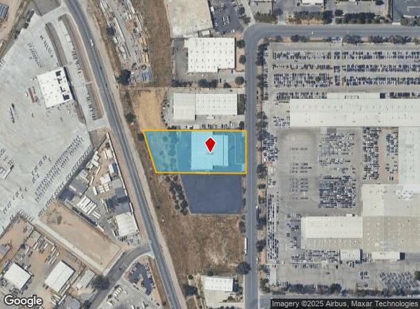
Property Record
2255 Via Cerro, Jurupa Valley, CA 92509
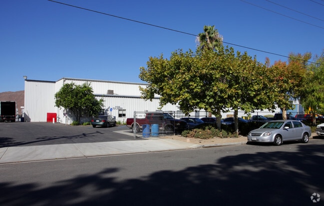
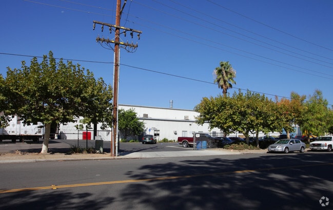

This Property Is For Sale
NEARBY LISTINGS FOR SALE OR LEASE
Property Detail
2255 Via Cerro
178-340-010
2.06 ACRES NET IN PAR 6 PM 013/049 PM 4819
Lightindustrial
Riverside
X
California
06065C0045H
6
2024
2.06 AC
2025
Riverside
040101
Inland Empire (California)
19,408 SF
Riverside-San Bernardino-Ontario, CA
DEMOGRAPHICS near 2255 Via Cerro
1 mile
3 mile
5 mile
2024 Total Population
3,480
71,567
254,549
2029 Population
3,667
74,921
264,373
Pop Growth 2024-2029
+ 5.37%
+ 4.69%
+ 3.86%
Average Age
34
34
35
2024 Total Households
887
19,381
72,213
HH Growth 2024-2029
+ 5.07%
+ 4.53%
+ 3.70%
Median Household Inc
$87,202
$69,750
$74,560
Avg Household Size
3.60
3.40
3.30
2024 Avg HH Vehicles
3.00
2.00
2.00
Median Home Value
$442,018
$397,081
$435,848
Median Year Built
1986
1971
1975
Nearby Places
Map Layers
Map Styles
 Street
 Aerial
Transit
 Traffic
 Biking
Places
Listings with unknown addresses are not visible on the map
- Restaurants
- Banks
- Shops
- Fitness
- Groceries
PUBLIC TRANSPORTATION
COMMUTER RAIL
Riverside-Downtown (91 Line - Southern California Regional Rail Authority (Metrolink), Inland Empire-Orange County Line - Southern California Regional Rail Authority (Metrolink), Riverside Line - Southern California Regional Rail Authority (Metrolink))
Drive
Walk
Distance
Riverside-Downtown (91 Line - Southern California Regional Rail Authority (Metrolink), Inland Empire-Orange County Line - Southern California Regional Rail Authority (Metrolink), Riverside Line - Southern California Regional Rail Authority (Metrolink))
9 min
4.0 mi
Drive
Walk
Distance
8 min
4.4 mi
AIRPORT
Ontario International
Drive
Walk
Distance
Ontario International
23 min
16.5 mi
John Wayne/Orange County
Drive
Walk
Distance
John Wayne/Orange County
56 min
45.8 mi
Nearby Properties
Address
Land Use
TOTAL SIZE
Lot Size
Zoning
Address
Land Use
TOTAL SIZE
Lot Size
Zoning
1,186,950 SF
54.77 AC
Address
Land Use
TOTAL SIZE
Lot Size
Zoning
1,025,132 SF
46.44 AC
Address
Land Use
TOTAL SIZE
Lot Size
Zoning
1,264,064 SF
64.44 AC
Address
Land Use
TOTAL SIZE
Lot Size
Zoning
1,000,177 SF
46 AC
Address
Land Use
TOTAL SIZE
Lot Size
Zoning
798,304 SF
42.64 AC
AMSP
Address
Land Use
TOTAL SIZE
Lot Size
Zoning
247,416 SF
10.17 AC
Address
Land Use
TOTAL SIZE
Lot Size
Zoning
505,152 SF
28.88 AC
Address
Land Use
TOTAL SIZE
Lot Size
Zoning
677,280 SF
34.53 AC
BLRS1AA
Address
Land Use
TOTAL SIZE
Lot Size
Zoning
615,310 SF
49.91 AC
Address
Land Use
TOTAL SIZE
Lot Size
Zoning
599,735 SF
33.25 AC
AMSP
Address
Land Use
TOTAL SIZE
Lot Size
Zoning
311,363 SF
34.60 AC
BLRS20M
Address
Land Use
TOTAL SIZE
Lot Size
Zoning
350,278 SF
1.21 AC
Address
Land Use
TOTAL SIZE
Lot Size
Zoning
340,120 SF
36.36 AC
Address
Land Use
TOTAL SIZE
Lot Size
Zoning
272,120 SF
13.05 AC
Address
Land Use
TOTAL SIZE
Lot Size
Zoning
525,110 SF
24.25 AC
Address
Land Use
TOTAL SIZE
Lot Size
Zoning
35,260 SF
9.55 AC
Address
Land Use
TOTAL SIZE
Lot Size
Zoning
447,190 SF
21.08 AC
Address
Land Use
TOTAL SIZE
Lot Size
Zoning
424,904 SF
23.03 AC
Address
Land Use
TOTAL SIZE
Lot Size
Zoning
1,056,072 SF
51.85 AC
AMSP
Address
Land Use
TOTAL SIZE
Lot Size
Zoning
156,241 SF
2.55 AC
Address
Land Use
TOTAL SIZE
Lot Size
Zoning
55.22 AC
AMSP
Address
Land Use
TOTAL SIZE
Lot Size
Zoning
139,454 SF
0.97 AC
DSP
Address
Land Use
TOTAL SIZE
Lot Size
Zoning
72,860 SF
7.71 AC
Address
Land Use
TOTAL SIZE
Lot Size
Zoning
750,700 SF
32.81 AC
AMSP
Address
Land Use
TOTAL SIZE
Lot Size
Zoning
210,004 SF
11.68 AC
Address
Land Use
TOTAL SIZE
Lot Size
Zoning
87,600 SF
0.39 AC
Address
Land Use
TOTAL SIZE
Lot Size
Zoning
12,372 SF
9.07 AC
BLRS20M
Address
Land Use
TOTAL SIZE
Lot Size
Zoning
394,232 SF
53.90 AC
The World's #1 Commercial Real Estate Marketplace
Connect with us
© 2026 CoStar Group
The information above has been obtained from sources believed reliable. While we do not doubt its accuracy we have not verified it and make no guarantee, warranty or representation about it. It is your responsibility to independently confirm its accuracy and completeness. Any projections, opinions, assumptions, or estimates used are for example only and do not represent the current or future performance of the property. The value of this transaction to you depends on tax and other factors which should be evaluated by your tax, financial, and legal advisors. You and your advisors should conduct a careful, independent investigation of the property to determine to your satisfaction the suitability of the property for your needs.