Property Record
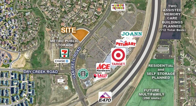
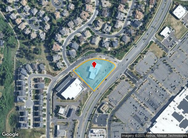
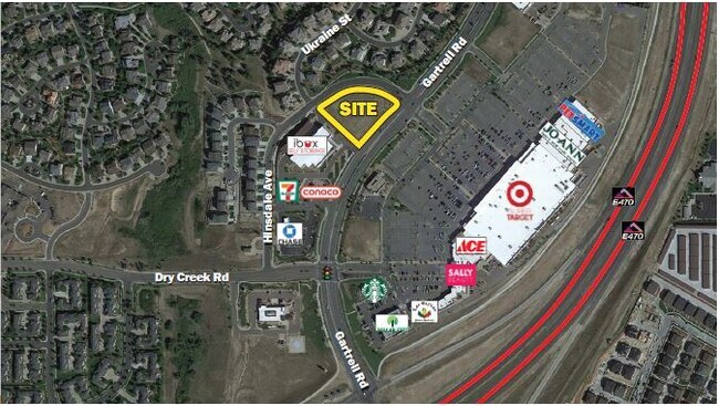
22650 E Hinsdale Ave, Aurora, CO 80016

NEARBY LISTINGS FOR SALE OR LEASE
-
-
View all Aurora listings for lease on LoopNet.com
Property Detail
22650 E Hinsdale Ave
Denver-Aurora-Centennial, CO
Gartrell Crossing Subdivision Flg No 2
2073-25-4-43-002
TOWNSHIP T5S MAPPLATB 503 MAPPLATP 5 SUBDIVISIONCD 025032 SUBDIVISIONNAME GARTRELL CROSSING SUBDIVISION FLG NO 2 BLOCK 001 LOT 002 LOT 2 BLK 1 GARTRELL CROSSING SUB FLG NO 2
Medicalbuilding
Arapahoe
X
Colorado
08005C0503L
2
2024
1.66 AC
2025
Outlying Arapahoe County
086500
Denver
10,700 SF
DEMOGRAPHICS near 22650 E Hinsdale Ave
1 Mile
3 Mile
5 Mile
2024 Total Population
12,076
72,044
178,258
2029 Population
12,099
73,816
184,721
Pop Growth 2024-2029
+ 0.19%
+ 2.46%
+ 3.63%
Average Age
43
39
38
2024 Total Households
4,941
24,382
60,976
HH Growth 2024-2029
+ 0.12%
+ 2.65%
+ 4.02%
Median Household Inc
$102,477
$138,976
$121,726
Avg Household Size
2.40
2.90
2.90
2024 Avg HH Vehicles
2.00
2.00
2.00
Median Home Value
$660,181
$674,577
$580,352
Median Year Built
2005
2005
2002
Nearby Places
Map Layers
Map Styles
 Street
 Aerial
- Restaurants
- Banks
- Shops
- Fitness
- Groceries
PUBLIC TRANSPORTATION
AIRPORT
Denver International
DRIVE
WALK
Distance
Denver International
28 min
24.6 mi
SALE & LEASE HISTORY
LISTING DATE
SALE/LEASE

Mar 30, 2017
For Sale
Mar 30, 2017
For Lease
Mar 09, 2017
For Sale
Dec 15, 2020
For Lease
Dec 15, 2020
For Sale
Apr 30, 2018
For Sale
Nearby Properties
Address
Land Use
TOTAL SIZE
Lot Size
Zoning
Address
Land Use
TOTAL SIZE
Lot Size
Zoning
355,644 SF
123.82 AC
Address
Land Use
TOTAL SIZE
Lot Size
Zoning
502,000 SF
22.32 AC
RPD
Address
Land Use
TOTAL SIZE
Lot Size
Zoning
346,890 SF
38.99 AC
AA1
Address
Land Use
TOTAL SIZE
Lot Size
Zoning
328,000 SF
33.52 AC
PUD
Address
Land Use
TOTAL SIZE
Lot Size
Zoning
448,149 SF
33.62 AC
RE470
Address
Land Use
TOTAL SIZE
Lot Size
Zoning
137,372 SF
5.86 AC
Address
Land Use
TOTAL SIZE
Lot Size
Zoning
129,701 SF
6.56 AC
Address
Land Use
TOTAL SIZE
Lot Size
Zoning
359,400 SF
20.36 AC
Address
Land Use
TOTAL SIZE
Lot Size
Zoning
5,380 SF
20.48 AC
RE470
Address
Land Use
TOTAL SIZE
Lot Size
Zoning
489,120 SF
20.10 AC
RE470
Address
Land Use
TOTAL SIZE
Lot Size
Zoning
319,078 SF
18.49 AC
RE470
Address
Land Use
TOTAL SIZE
Lot Size
Zoning
40,249 SF
13.44 AC
Address
Land Use
TOTAL SIZE
Lot Size
Zoning
176,000 SF
10.83 AC
PUD
Address
Land Use
TOTAL SIZE
Lot Size
Zoning
151,246 SF
13.25 AC
RE470
Address
Land Use
TOTAL SIZE
Lot Size
Zoning
389,337 SF
22.01 AC
Address
Land Use
TOTAL SIZE
Lot Size
Zoning
308,396 SF
19.45 AC
RPCZD
Address
Land Use
TOTAL SIZE
Lot Size
Zoning
379,109 SF
16.45 AC
Address
Land Use
TOTAL SIZE
Lot Size
Zoning
298,589 SF
14.52 AC
RPCZD
Address
Land Use
TOTAL SIZE
Lot Size
Zoning
65,120 SF
11.17 AC
Address
Land Use
TOTAL SIZE
Lot Size
Zoning
40,935 SF
3.38 AC
RE470
Address
Land Use
TOTAL SIZE
Lot Size
Zoning
206,122 SF
24.97 AC
Address
Land Use
TOTAL SIZE
Lot Size
Zoning
53,736 SF
17.28 AC
RPD
Address
Land Use
TOTAL SIZE
Lot Size
Zoning
121,777 SF
10.94 AC
RE470
Address
Land Use
TOTAL SIZE
Lot Size
Zoning
91,380 SF
5.52 AC
Address
Land Use
TOTAL SIZE
Lot Size
Zoning
69,543 SF
9.95 AC
Address
Land Use
TOTAL SIZE
Lot Size
Zoning
140,000 SF
24.16 AC
AMU
Address
Land Use
TOTAL SIZE
Lot Size
Zoning
174,444 SF
15.64 AC
RPD
Address
Land Use
TOTAL SIZE
Lot Size
Zoning
32,811 SF
6.48 AC
Address
Land Use
TOTAL SIZE
Lot Size
Zoning
148,579 SF
10.31 AC
PUD
Address
Land Use
TOTAL SIZE
Lot Size
Zoning
55,800 SF
12.80 AC
The World's #1 Commercial Real Estate Marketplace
Connect with us
© 2026 CoStar Group
The information above has been obtained from sources believed reliable. While we do not doubt its accuracy we have not verified it and make no guarantee, warranty or representation about it. It is your responsibility to independently confirm its accuracy and completeness. Any projections, opinions, assumptions, or estimates used are for example only and do not represent the current or future performance of the property. The value of this transaction to you depends on tax and other factors which should be evaluated by your tax, financial, and legal advisors. You and your advisors should conduct a careful, independent investigation of the property to determine to your satisfaction the suitability of the property for your needs.