Property Record
22835 Mcauliffe Dr, Robertsdale, AL 36567
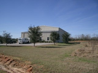

Property Detail
22835 Mcauliffe Dr
47-01-01-0-000-003.003
274.4' X 252.8' IRR COM AT THE NW COR SEC 1 RUN S 1235.15' TH SE 309.68' TO THE POB, TH CONT SE 274.4', TH ALG A CURVE TO THE
Warehouse
BALDWIN
B and X Area of moderate flood hazard, usually the area between the limits of the 100-year and 500-year floods.
Alabama
0
1.90 AC
2025
Baldwin County
010908
Mobile
5,066 SF
Daphne-Fairhope-Foley, AL
NEARBY LISTINGS FOR SALE OR LEASE
DEMOGRAPHICS near 22835 Mcauliffe Dr
1 mile
3 mile
5 mile
2025 Total Population
1,671
14,638
24,068
2030 Population
1,840
15,870
26,143
Pop Growth 2025-2030
+ 10.11%
+ 8.42%
+ 8.62%
Average Age
36
38
39
2025 Total Households
618
5,305
8,655
HH Growth 2025-2030
+ 10.19%
+ 8.44%
+ 8.68%
Median Household Inc
$92,072
$65,610
$68,814
Avg Household Size
2.70
2.70
2.60
2025 Avg HH Vehicles
2.00
2.00
2.00
Median Home Value
$254,518
$236,879
$242,893
Median Year Built
2004
1999
1998
Nearby Places
Map Layers
Map Styles
 Street
 Aerial
Layers
 Traffic
 Biking
Places
Listings with unknown addresses are not visible on the map
- Restaurants
- Banks
- Shops
- Fitness
- Groceries
PUBLIC TRANSPORTATION
AIRPORT
Mobile International
Drive
Walk
Distance
Mobile International
43 min
30.4 mi
Pensacola International
Drive
Walk
Distance
Pensacola International
59 min
38.3 mi
Mobile Regional
Drive
Walk
Distance
Mobile Regional
65 min
40.1 mi
Freight Ports
Port of Mobile
Drive
Walk
Distance
Port of Mobile
37 min
26.5 mi
Nearby Properties
Address
Land Use
TOTAL SIZE
Lot Size
Zoning
Address
Land Use
TOTAL SIZE
Lot Size
Zoning
2,673 SF
14 AC
Address
Land Use
TOTAL SIZE
Lot Size
Zoning
129,533 SF
17 AC
Address
Land Use
TOTAL SIZE
Lot Size
Zoning
46,778 SF
3.65 AC
Address
Land Use
TOTAL SIZE
Lot Size
Zoning
24,873 SF
32 AC
Address
Land Use
TOTAL SIZE
Lot Size
Zoning
Address
Land Use
TOTAL SIZE
Lot Size
Zoning
39,816 SF
3.80 AC
Address
Land Use
TOTAL SIZE
Lot Size
Zoning
Address
Land Use
TOTAL SIZE
Lot Size
Zoning
9,272 SF
8.30 AC
Address
Land Use
TOTAL SIZE
Lot Size
Zoning
4,442 SF
10 AC
Address
Land Use
TOTAL SIZE
Lot Size
Zoning
33,925 SF
4.40 AC
Address
Land Use
TOTAL SIZE
Lot Size
Zoning
52,339 SF
5.20 AC
Address
Land Use
TOTAL SIZE
Lot Size
Zoning
54,922 SF
11 AC
Address
Land Use
TOTAL SIZE
Lot Size
Zoning
44,289 SF
8.30 AC
Address
Land Use
TOTAL SIZE
Lot Size
Zoning
33,862 SF
2 AC
Address
Land Use
TOTAL SIZE
Lot Size
Zoning
32,361 SF
8.50 AC
Address
Land Use
TOTAL SIZE
Lot Size
Zoning
31,359 SF
19 AC
Address
Land Use
TOTAL SIZE
Lot Size
Zoning
13,140 SF
20 AC
Address
Land Use
TOTAL SIZE
Lot Size
Zoning
11,553 SF
9.20 AC
Address
Land Use
TOTAL SIZE
Lot Size
Zoning
77,858 SF
3.20 AC
Address
Land Use
TOTAL SIZE
Lot Size
Zoning
25,718 SF
2.17 AC
Address
Land Use
TOTAL SIZE
Lot Size
Zoning
3,000 SF
5.70 AC
Address
Land Use
TOTAL SIZE
Lot Size
Zoning
12,774 SF
11.20 AC
Address
Land Use
TOTAL SIZE
Lot Size
Zoning
26,742 SF
1.90 AC
Address
Land Use
TOTAL SIZE
Lot Size
Zoning
53,144 SF
13 AC
Address
Land Use
TOTAL SIZE
Lot Size
Zoning
58,099 SF
6.70 AC
Address
Land Use
TOTAL SIZE
Lot Size
Zoning
11,825 SF
6.60 AC
Address
Land Use
TOTAL SIZE
Lot Size
Zoning
6,427 SF
2.10 AC
Address
Land Use
TOTAL SIZE
Lot Size
Zoning
15,017 SF
3.95 AC
Address
Land Use
TOTAL SIZE
Lot Size
Zoning
13,721 SF
1.04 AC
Address
Land Use
TOTAL SIZE
Lot Size
Zoning
51,241 SF
20 AC
The World's #1 Commercial Real Estate Marketplace
Connect with us
© 2026 CoStar Group
The information above has been obtained from sources believed reliable. While we do not doubt its accuracy we have not verified it and make no guarantee, warranty or representation about it. It is your responsibility to independently confirm its accuracy and completeness. Any projections, opinions, assumptions, or estimates used are for example only and do not represent the current or future performance of the property. The value of this transaction to you depends on tax and other factors which should be evaluated by your tax, financial, and legal advisors. You and your advisors should conduct a careful, independent investigation of the property to determine to your satisfaction the suitability of the property for your needs.