Property Record
2300 E Chestnut Dr, Cheyenne, WY 82001
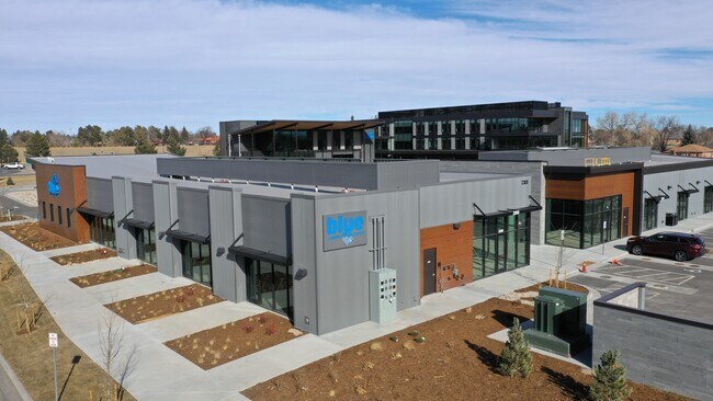

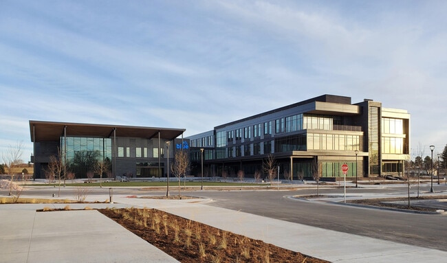
Property Detail
2300 E Chestnut Dr
1-6157-0005-0000-1
EAST57.6 FT OF LOT21 W5 FT OF LOT22
Commercialnec
LARAMIE
B and X Area of moderate flood hazard, usually the area between the limits of the 100-year and 500-year floods.
Wyoming
2025
7.40 AC
2025
I-80 Corridor/Cheyenne
000602
Other Market Areas
91,021 SF
Cheyenne, WY
NEARBY LISTINGS FOR SALE OR LEASE
DEMOGRAPHICS near 2300 E Chestnut Dr
1 mile
3 mile
5 mile
2025 Total Population
8,205
59,253
85,556
2030 Population
8,150
59,223
86,307
Pop Growth 2025-2030
(0.67%)
(0.05%)
+ 0.88%
Average Age
42
40
40
2025 Total Households
3,781
26,156
35,900
HH Growth 2025-2030
(0.48%)
+ 0.15%
+ 0.94%
Median Household Inc
$71,707
$67,992
$72,868
Avg Household Size
2.10
2.20
2.30
2025 Avg HH Vehicles
2.00
2.00
2.00
Median Home Value
$270,812
$297,192
$324,821
Median Year Built
1953
1973
1979
Nearby Places
Map Layers
Map Styles
 Street
 Aerial
Layers
 Traffic
 Biking
Places
Listings with unknown addresses are not visible on the map
- Restaurants
- Banks
- Shops
- Fitness
- Groceries
SALE & LEASE HISTORY
LISTING DATE
SALE/LEASE

Jan 03, 2020
For Lease
Feb 10, 2021
For Lease
Nearby Properties
Address
Land Use
TOTAL SIZE
Lot Size
Zoning
Address
Land Use
TOTAL SIZE
Lot Size
Zoning
240.51 AC
A2
Address
Land Use
TOTAL SIZE
Lot Size
Zoning
639,397 SF
67.52 AC
Address
Land Use
TOTAL SIZE
Lot Size
Zoning
Address
Land Use
TOTAL SIZE
Lot Size
Zoning
172,393 SF
12.16 AC
Address
Land Use
TOTAL SIZE
Lot Size
Zoning
189,952 SF
11.15 AC
HR2
Address
Land Use
TOTAL SIZE
Lot Size
Zoning
Address
Land Use
TOTAL SIZE
Lot Size
Zoning
148,018 SF
Address
Land Use
TOTAL SIZE
Lot Size
Zoning
210,717 SF
18.28 AC
Address
Land Use
TOTAL SIZE
Lot Size
Zoning
136,488 SF
13.38 AC
CB
Address
Land Use
TOTAL SIZE
Lot Size
Zoning
219,227 SF
21.97 AC
CB
Address
Land Use
TOTAL SIZE
Lot Size
Zoning
118,588 SF
3.20 AC
CB
Address
Land Use
TOTAL SIZE
Lot Size
Zoning
69,726 SF
0.80 AC
CBD
Address
Land Use
TOTAL SIZE
Lot Size
Zoning
323,835 SF
Address
Land Use
TOTAL SIZE
Lot Size
Zoning
135,427 SF
6.61 AC
Address
Land Use
TOTAL SIZE
Lot Size
Zoning
109,096 SF
4.03 AC
MR2
Address
Land Use
TOTAL SIZE
Lot Size
Zoning
193,881 SF
21.36 AC
CB
Address
Land Use
TOTAL SIZE
Lot Size
Zoning
109,744 SF
7.04 AC
Address
Land Use
TOTAL SIZE
Lot Size
Zoning
204,822 SF
6.88 AC
HR1
Address
Land Use
TOTAL SIZE
Lot Size
Zoning
76,524 SF
6 AC
Address
Land Use
TOTAL SIZE
Lot Size
Zoning
81,948 SF
9.39 AC
CB
Address
Land Use
TOTAL SIZE
Lot Size
Zoning
142,588 SF
3.54 AC
PUD
Address
Land Use
TOTAL SIZE
Lot Size
Zoning
37,714 SF
4.29 AC
Address
Land Use
TOTAL SIZE
Lot Size
Zoning
108,716 SF
12.45 AC
Address
Land Use
TOTAL SIZE
Lot Size
Zoning
69,941 SF
4.31 AC
LI
Address
Land Use
TOTAL SIZE
Lot Size
Zoning
88,107 SF
10.73 AC
Address
Land Use
TOTAL SIZE
Lot Size
Zoning
86,860 SF
1.70 AC
CB
Address
Land Use
TOTAL SIZE
Lot Size
Zoning
59,325 SF
0.85 AC
CBD
Address
Land Use
TOTAL SIZE
Lot Size
Zoning
96,088 SF
8.34 AC
Address
Land Use
TOTAL SIZE
Lot Size
Zoning
69,103 SF
17.34 AC
The World's #1 Commercial Real Estate Marketplace
Connect with us
© 2026 CoStar Group
The information above has been obtained from sources believed reliable. While we do not doubt its accuracy we have not verified it and make no guarantee, warranty or representation about it. It is your responsibility to independently confirm its accuracy and completeness. Any projections, opinions, assumptions, or estimates used are for example only and do not represent the current or future performance of the property. The value of this transaction to you depends on tax and other factors which should be evaluated by your tax, financial, and legal advisors. You and your advisors should conduct a careful, independent investigation of the property to determine to your satisfaction the suitability of the property for your needs.